You are using an out of date browser. It may not display this or other websites correctly.
You should upgrade or use an alternative browser.
You should upgrade or use an alternative browser.
Images storage decisions
- Thread starter NeboScan
- Start date
Hello,Moved your thread
I don't understand. What's mean "moved your thread"? Do I have ability to ask the question? Or there are special rules?
Thank you
You originally posted your thread in the wrong section. Therefore, I moved itHello,
I don't understand. What's mean "moved your thread"? Do I have ability to ask the question? Or there are special rules?
Thank you
Thank you for clarification. Ok, to avoid potential mistake would you please to help me? I have a question related to the UAS's collected data storage. What forum's topic is correct for this question?You originally posted your thread in the wrong section. Therefore, I moved it
Thank you
I store my photos and videos on one of my desktop hard drives, and back them up to the cloud. Diskspace is cheap and I don't compress anything.
Felix le Chat
Well-Known Member
Ditto with tstr14's comment. All RAW shots get backed up to external SSD as a permanent archive for unprocessed originals. Drives labelled by year.
Last count for dedicated 1TB SSD: in excess of 22,000 DNG stills and 14,000 documents.
Last count for dedicated 1TB SSD: in excess of 22,000 DNG stills and 14,000 documents.
Well, but what to do if there are three projects with 12000-14000 pictures for each one?I store my photos and videos on one of my desktop hard drives, and back them up to the cloud. Diskspace is cheap and I don't compress anything.
I'm trying to understand your question. The number of files has little to no bearing. My picture hard drive contains 37,000 picture files. On a 4TB drive, that means my files take up about 1/12 (or .083 if decimals are your thing) of the space on the drive.Well, but what to do if there are three projects with 12000-14000 pictures for each one?
Given the number of photos you are talking about, I would create one master folder for each project with sub folders in each one. Give each sub folder a relevant name to make finding the photos you are looking for easier. You can create as many sub folders as you desire. You can even create sub folders in the folders, so it looks like a "tree".
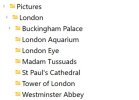
For example, say project one is London. The main folder is named London. Under that folder, you have sub groups for Tower of London, London Aquarium, Westminster Abbey, London Eye, Madam Tussuads, Buckingham Palace and St. Paul's Cathedral.
So when you open your computer file manager, you see this:

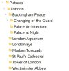
Note the arrow next to Buckingham Palace. Click it and you find more sub folders:

Again, note the arrow beside Changing of the Guard. Click for the sub folders under there:

Remember, this is all under ONE project, London. You can make it as complex or simple as you want since you can make as many folders as you wish and name them whatever you want.
Thank you for details. I appreciate that.
I explained you what my question is.
Let's calculate: 14000x3=42000 pictures.
The average size of each picture is 40000 KB (or 40 MB), therefore the total will be
40 x 42000=1680000 MB or 1.68 TB.
The processing can be made on laptop with 1 TB or desktop with 2 TB.
The remote location as cloud or outside disk is not working due to low speed between CPU and outside storage.
I'm looking for solution to use existing hardware (buying more and more servers is not a decision).
RSLC compress the files at least 3 times that means 1.68/3 = 0.56 TB which allows me both process (Pix4D) and storage geotagged images in one place.
That's my question.
Thank you
Speed using an external drive is always an issue compared to internal storage. Even cloud storage is slow comparatively speaking. How much compression do you need? Would a simple zip program like 7-zip be sufficient? I don't know what price line you're looking at for the compression software, but you can buy a 2tb external drive for around $60 and a 2TB SSD external for a bit over $100.
Last edited:
Thank you for details. I appreciate that.
I explained you what my question is.
Let's calculate: 14000x3=42000 pictures.
The average size of each picture is 40000 KB (or 40 MB), therefore the total will be
40 x 42000=1680000 MB or 1.68 TB.
The processing can be made on laptop with 1 TB or desktop with 2 TB.
The remote location as cloud or outside disk is not working due to low speed between CPU and outside storage.
I'm looking for solution to use existing hardware (buying more and more servers is not a decision).
RSLC compress the files at least 3 times that means 1.68/3 = 0.56 TB which allows me both process (Pix4D) and storage geotagged images in one place.
That's my question.
Thank you
Similar threads
- Replies
- 11
- Views
- 691
- Replies
- 0
- Views
- 773
- Replies
- 59
- Views
- 5K
- Replies
- 1
- Views
- 2K
DJI Drone Deals
New Threads
-
-
-
-
DJI Fly 1.5 keeps crashing on new OS Android 13, if I update will I lose CJD and DH?
- Started by phad
- Replies: 1
-
4 Pro STILL doubting if the Mavic 4 Pro combo upgrade is worth it?
- Started by christangey
- Replies: 5
Members online
Total: 4,039 (members: 11, guests: 4,028)


