DJI Mavic, Air and Mini Drones
Friendly, Helpful & Knowledgeable Community
Join Us Now

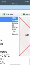
Is anyone paying attention to TFR 1/1155 over DC?

I live in Minnesota and pretty sure I don't have enough battery to get to DC and back so I guess the TFR does not affect me :)
Actually I lived in DC for a year while I was in the army (long time ago) and even then it was restricted air space which only makes sense.
 
ALERT! ALERT! The reason why are all of the airplanes that are currently flying around Washington D.C. is because the Federal Aviation Administration (FAA) placed a Temporary Flight Restriction (TFR) over the entire Washington D.C. area. This is the largest TFR that I have ever seen before. Here are the details directly from the FAA: FDC 1/1155 ZDC DC .. FLIGHT RESTRICTIONS, WASHINGTON, DC. EFFECTIVE 1101102040 UTC [1:11pm 1/12/2021 EST] UNTIL FURTHER NOTICE. THIS NOTICE WILL REPLACE NOTAM 0/9463 DUE TO TECHNICAL ERROR, NO CHANGES IN RESTRICTIONS. PURSUANT TO TITLE 14 CFR SECTION 99.7, SPECIAL SECURITY INSTRUCTIONS. A. EXCEPT FOR FAA APPROVED DOD, LAW ENFORCEMENT, AND WAIVERED LIFEGUARD/AIR AMBULANCE FLIGHTS, ALL VFR AIRCRAFT OPERATIONS WITHIN 30NM OF 385134N/0770211W OR THE WASHINGTON /DCA/ VOR/DME, FROM THE SURFACE UP TO BUT NOT INCLUDING FL180 [18,000 feet], ARE RESTRICTED TO AN INDICATED AIRSPEED OF 180 KNOTS OR LESS, IF CAPABLE. IF UNABLE, THE PILOT MUST CONTACT THE APPROPRIATE ATC FACILITY AND ADVISE THEM OF THE AIRCRAFT'S OPERATIONAL LIMITATIONS. B. ALL VFR AIRCRAFT OPERATIONS WITHIN THE AIRSPACE BETWEEN 30 NMR AND 60 NMR [Nautical Mile Radius OF 385134N/0770211W OR THE WASHINGTON /DCA/ VOR/DME, FROM THE SURFACE UP TO BUT NOT INCLUDING FL180, ARE RESTRICTED TO AN INDICATED AIRSPEED OF 230 KNOTS OR LESS, IF CAPABLE. IF UNABLE THE PILOT MUST CONTACT THE APPROPRIATE ATC FACILITY AND ADVISE THEM OF THE AIRCRAFT'S OPERATIONAL LIMITATIONS PRIOR TO ENTERING THE 60 NMR OF THE WASHINGTON /DCA/ VOR/DME. This information is telling all AIRMEN [pilots] to slow their airspeed to less than 180 knots inside the 60-mile radius around Washington D.C.

"THIS IS NOT A DRILL". Go to: skyvector.com, scroll and minimize the map of the USA. Then scroll across to the Washington D.C. area. Move your mouse into the red and yellow area to see the TFR 1/1155 box will open, double click your mouse when you see a new page that shows the same information that I provided above is the in fact the REAL TRUTH. The TFR tells pilots that there is a SPEED LIMIT in the area around and above Washington D.C... until further notice from the FAA.

Shall we discuss about this issue that is currently happening in the United States!
View attachment 121668
Did you even read the issue date of the TFR? It has been in place for 10 years. So why the surprise?
5464D4EB-BFDC-40BC-93C8-97400D5D872D.jpeg
Your response to a staff member has placed you on the list you really do not wish to be on. Make sure you read the Community Rules regarding moderation on our forums.
 
In place of training, competency, investigation and professionalism, we have the federal government..
The FAA rubber stamps MCAS (Must Crash Aircraft System) for boeing, and yet they expect respect....... really?..
Haven't seen even one FAA failure go to jail for murder.... until they are all cleaned out, its a dirty rogue agency.
So exactly how would you handle a "Sensitive Area" if you were in charge of Airspace? Remember you have to do everything in your power to mitigate risk, assure safety of the people in the area who need it, all the while disrupting normal "business as usual" to the best of your ability. Exactly how would YOU manage difficult and extremely sensitive airspace?

Don't forget this isn't just for our toy UAS but manned aircraft (private, Corp, and Airline).
 
So this is a wild speculation on my part and I'm curious. Is it possible that the end goal of remote ID is to give the FAA a means to ground drones in mass when a situation requires? For example, if one were to fly into a no fly zone as referenced in this post, the drone is either not allowed to fly there or lands.

I recall on 9-11, all planes were grounded nationwide. But now that there are so many drones, and some of them heavy, would it not be in the national security interest to have a means to bring them down in the event of an emergency?

Again - just curious.

Sorry to drag this off topic...

BACK TO LURKING!!!!
Remote ID is now just a broadcast from the SUAS and will not require a link to a USS (thank God some USS won’t be getting $20 a month or more so we can fly). Since it is broadcast only, there will be no means to receive a signal with every sUAS and ground them en masse.

Those engaged in BVLOS missions may be a different story since they are not operating in VLOS.
 
So this is a wild speculation on my part and I'm curious. Is it possible that the end goal of remote ID is to give the FAA a means to ground drones in mass when a situation requires? For example, if one were to fly into a no fly zone as referenced in this post, the drone is either not allowed to fly there or lands.

I recall on 9-11, all planes were grounded nationwide. But now that there are so many drones, and some of them heavy, would it not be in the national security interest to have a means to bring them down in the event of an emergency?

Again - just curious.

Sorry to drag this off topic...

BACK TO LURKING!!!!
It would be the EXACT same "means" that was enacted on that day of 9-11. Verbal/electronic communications via the Aviation community (Commercial and General Aviation) they can issue a GroundStop of all traffic. The entire USA was a TFR which grounded roughly 4,000 planes at that moment and prevented 36k - 40k a day for the next few days.

It's interesting to note that the single person who had that call, Ben Sliney, it was his first DAY in that position. He had a long history in ATC in general but that was his first day as chief of air-traffic-control operations at the FAA's command center in Herndon, Va. and it was his call to immediately stop any aircraft coming towards NYC etc which ultimately turned into a full GroundStop for all US aviation (commercial and general aviation).

Here's a graphic showing how every plane in the air was brought down ASAP for the sake of National Safety.
To view this content we will need your consent to set third party cookies.
For more detailed information, see our cookies page.
 
Glad to see some chatter about this. I was composing a new post but saw this one as soon as I typed TFR for the subject. I live under that broad TFR and had not seen it on Airmap/Kitty Hawk and have flown a Class B airport LAANC-approved flight since 1/10. I just happened to look at SkyVector and was alarmed to see it. There is, as some have posted, always a TFR around D.C. but I've not seen one that large.

Am I interpreting it correctly in that it's a speed limitation for aircraft and would not apply to drones, especially my (registered) Mini 2? Are TFRs hard-geofenced (guessing not!)? I don't understand why I don't see it on the apps - in the past, I've seen a future dated TFR on Sky Vector, nothing on AirMap/KH, then when the day arrived they show up on AirMap/KH - so that all pans out. (I'm guessing that all of you commercial pilots do this regularly before jobs to make sure you don't waste a trip somewhere!). Is it not on the apps because it doesn't affect drones?

I'm not questioning anything related to the TFR, I just want to make sure I'm understating it and not in violation. Looks like it might be around for a while and has been around for a while. For what it's worth, I'm a recreational flyer.
 
Last edited:
I am looking to fly in Culpepper VA. It says there is FDC 1/1155 Scheduled (ends in 28 years) Will I still be able to fly in this location? Does FDC 1/1155 effect UAS?
 

DJI Drone Deals

New Threads

Forum statistics

Threads
135,143
Messages
1,602,933
Members
163,631
Latest member
kkeller
Want to Remove this Ad? Simply login or create a free account