DJI Mavic, Air and Mini Drones
Friendly, Helpful & Knowledgeable Community
Join Us Now

Is it worth even taking drone to Hawaii?

I've flown many times on the Big Island and got some great shots. On the east side of the island, just above Black Sands Beach, found 6 month old lava flow adjacent to Isaac Hale Beach Park - Pohoiki, site of the May 2018 lav flow. Felt like quite a pioneer as it was quite an effort to find, but what a joy to film.
 
You're welcome. The DJI maps are located at DJI Flysafe maps

I would also strongly suggest you download the apps- Airmap and Kittykawk. Both of these apps can get you LAANC ATC authorization, pretty much immediately if you can't do it in advance. There are a few other programs that can do it as well. B4UFly comes to mind.

And as you're going to an island that will have variable winds, I also suggest you download UAV Forecast and possibly the Windy app. You're going to want to know the wind conditions to keep your drone out of trouble.
Fly early mornings. Less traffic, but the important thing is the wind comes up in the afternoon
 
  • Like
Reactions: vindibona1
My motto is: "Where ever I go, I take my drone!".
And if I want to fly from a boat: the winds are often strong, so I choose my M2P rather than the Mini 2 and I surely won't forget ND/CPL filters!
 
You're welcome. The DJI maps are located at DJI Flysafe maps

I would also strongly suggest you download the apps- Airmap and Kittykawk. Both of these apps can get you LAANC ATC authorization, pretty much immediately if you can't do it in advance. There are a few other programs that can do it as well. B4UFly comes to mind.

And as you're going to an island that will have variable winds, I also suggest you download UAV Forecast and possibly the Windy app. You're going to want to know the wind conditions to keep your drone out of trouble.
The LAANC ATC authorization would be for flying into those shaded zones in the FLysafe map around the airports?

You'd actually be able to fly into those zones or do you get authorization even if you're near those shaded zones?
 
Dude totally take it! Lived Hawaii for the past 10 years and honestly it's like the wild Wild West out there nobody follows any rules with their drones and gets away with it daily. Not saying you should for sure respect the airspaces and especially if military areas and not flying over people on beaches...but have fun and fly everyone does.

Do any of the mapping apps show if you're in the path of those tour planes and copters?

There must be a lot of those small planes and helicopters operating all over the islands.
 
If you are going on a chartered whale watching trip, I wouldn’t plan on flying from the boat. You will be in constant motion and it’s very unlikely that the charter company will allow a drone to take off from the boat... too much liability from their perspective (not arguing, just many places with no drone experience start with no). Plus there are usually a ton of people packed on those tours.
How much are private charters?

Presumably they can just say in place so that you can launch and land easily?
 
The LAANC ATC authorization would be for flying into those shaded zones in the FLysafe map around the airports?

You'd actually be able to fly into those zones or do you get authorization even if you're near those shaded zones?
It all depends on the specifics of the area and the local laws. If you see you're in a shaded area the best course of action is to do some further research before you get there to avoid wasted time and disappointment.
 
The various zones in FlySafe maps can vary in reason. Blue Authorization zones do often appear on runway approach paths even for airports in G space. You don't need LAANC approval in G space, but you still have to fly safe and avoid manned aircraft.
Also blue zones can appear for TFRs. If you tap within a zone, it will detail why the zone is there.
 
We went to Hawaii in 2017 and maybe things were different there then. LAANC was not there yet. I call the Air Traffic Control tower for authorization and also on a couple of beaches, asked the park staff. I had no problem getting the go ahead to fly. As do all of us here, I flew following the FAA guidelines. These are from Oahu and Maui. I think LAANC should be pretty helpful there now. Here are some shots I took to give you an idea of what you can get, but much better. These were very quickly edited from JPG files. Not the best. If you're taking off from outside a restricted area, make sure you start recording before you take off so it shows you were legit in case you accidently fly over that area.
 

Attachments

  • DJI_0062.jpg
    DJI_0062.jpg
    3.6 MB · Views: 26
  • DJI_0155.jpg
    DJI_0155.jpg
    3.2 MB · Views: 26
  • DJI_0190.jpg
    DJI_0190.jpg
    2.9 MB · Views: 27
  • DJI_0210.jpg
    DJI_0210.jpg
    3.6 MB · Views: 27
  • DJI_0286.jpg
    DJI_0286.jpg
    4.5 MB · Views: 24
  • Like
Reactions: Alexmd
I've been taking my Mavic Pro the last 3 1/2 years and always capture some great views, mostly from the Big Island and Kauai. I'm sure Maui views from the air will be great. Be aware that weather changes quickly and gusts can come up on you quickly. On the north side of the Big Island, I flew out over a cliff about 2,000 feet elevation and got a wind warning, so I brought her home and landed quickly. Make sure that doesn't happen with the mini as it might just blow you away.
 
Are there more restrictions on Oahu, particularly around Honolulu, than on the other islands?

Any places near Diamond Head to launch and land?
 
Many good viewing areas in Maui. Would not travel without my Mavic 2 Pro.
Right now, the high temps are about 80. Always breezy but beautiful.
 

Attachments

  • DJI_0776.JPG
    DJI_0776.JPG
    7.1 MB · Views: 13
  • DJI_0783.JPG
    DJI_0783.JPG
    8 MB · Views: 13
I've been taking my Mavic Pro the last 3 1/2 years and always capture some great views, mostly from the Big Island and Kauai. I'm sure Maui views from the air will be great. Be aware that weather changes quickly and gusts can come up on you quickly. On the north side of the Big Island, I flew out over a cliff about 2,000 feet elevation and got a wind warning, so I brought her home and landed quickly. Make sure that doesn't happen with the mini as it might just blow you away.
Thank you for the advice, will definitely keep track of wind speeds.
 
Found this article with some info. about Hawaii-specific drone regs.


I look at Airmap of the Waikiki and Diamond Head area and I see no restrictions. I know you can't launch/land from within the DH park but it sounds like there are places nearby.

State of Hawaii prohibits drones in the state park. Click [
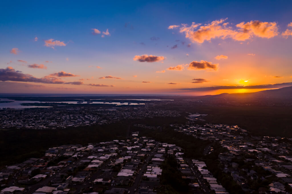
here] to read more about the drone policy in Hawaii. Diamond head is a state park and no drone is allowed inside the park. However, Diamond head Rd has a look out spot, so you can park and fly a drone.


The parking area is crowded with a bunch of people with drones, especially sunrise time (around 7am), so watch out for the midair crash. It is technically a part of Class B airspace. Make sure to use LAANC apps and get an approval before flight. In case you don't know how to get an approval, click [here] to read step by step guide.

 
  • Like
Reactions: hortalonus
The answer to the original question is "Yes".DJI_0985.JPG
 

Attachments

  • DJI_0933e.jpg
    DJI_0933e.jpg
    5 MB · Views: 4
  • DJI_0811.JPG
    DJI_0811.JPG
    7.7 MB · Views: 4
I have had some fantastic experiences with my Mavic in Hawaii. I was able to fly off of a charter boat at Molokini Crater last year. I gave the guide my pics and came back a year later to see them on his advertisement. ( I thought it was cool ) On the big island this year I was able to grab this pic using the zoom function. Yes take your drone!!!

View attachment 119795View attachment 119796
Do you have contact information for whomever let you fly from their boat? I'll be in Maui in March and would love to get some shots like these.
[email protected]
 
Lycus Tech Mavic Air 3 Case

DJI Drone Deals

New Threads

Forum statistics

Threads
131,060
Messages
1,559,403
Members
160,044
Latest member
ken28e