I will be visiting Venice, La. and planned to do some drone flying but send to be a lot of heliports and small airports nearby. Is this a warning or total no fly zone
You may wish to download the "AirMap" App. I've used it for a long time and always found it to be advantageous. The app gives you quite a bit of information with regard to the airspace.
If you have AirMap or Kittyhawk apps, do a LANNC authorization request for that area. If you get approval then you should be good to fly. Of course within the authorization parameters. Also there may be other laws or rules pertaining to flying your drone in this area not tied to the LANNC authorization.
Good luck and happy flying.
This may be a dumb question ... especially to those not living in the USA, please don't think of me as a 'dumb American ? ... but is LAANC specific to the USA or is it worldwide. I thought FAA only has jurisdiction in the USA. Am I wrong?
This may be a dumb question ... especially to those not living in the USA, please don't think of me as a 'dumb American ? ... but is LAANC specific to the USA or is it worldwide. I thought FAA only has jurisdiction in the USA. Am I wrong?
@theflyingtexan,
The area you are looking at is uncontrolled , Class G airspace. Legally you can fly there, however as you pointed out....there are 6 busy oil/gas Heliports and 2 Seaplane bases all within about 2 miles from your proposed flight area! Those airfields will have helicopter and seaplane traffic nearby which often fly at low altitudes. The A-381 is an “Alert Area” which is another warning to all pilots of the high volume of helicopter and seaplane traffic from the Surface to 2,000ft MSL.
If you need to fly there I would spend some time observing the flow of traffic, stay as low as you can for your mission, and enlist the help of extra observers if available. Basically, use extreme caution in that area and remain vigilant for manned aircraft. The aircraft will be taking off and landing which means they will definitely be below 500 ft as they transition between landing areas, low level routes, waterways, and oil rigs.
Hope this helps
If you have AirMap or Kittyhawk apps, do a LANNC authorization request for that area. If you get approval then you should be good to fly. Of course within the authorization parameters. Also there may be other laws or rules pertaining to flying your drone in this area not tied to the LANNC authorization.
Good luck and happy flying.
It is part of the usual process...
I routinely got it from flying points in either or both of the areas shown.
A better idea if it’s a frequent area for you is authorization via FAA DroneZone. I have one for 2 years encompassing almost 4 square miles... only took about a week to get. You do have to give them latitude and longitude of the perimeter.
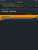
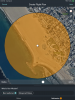
I’m attaching two pictures of a request for Venice beach on the AirMap app. If you look at the area of the orange circle I’ve got it set to 400 meter radius. In the other picture you can see that there is a 50 ft. altitude restriction. If you look in the top right corner of either picture you will see ”Next”. Tap that and you will see the screen for setting up your flight plan.
I can tell you from experience (I’ve requested LANNC in another area of CA.) if you request an altitude higher than allowed, your request is automatically refused.
My suggestion, play with the app. Get to understand how it works. You will find it quite easy.
Good luck with your flights.
@Fun Flyer, just to clarify it is my understanding that the OP was looking to fly at Venice, Louisiana not Venice Beach, CA. Check the lat/long presented in the first post. I think that is why there may be some confusion with AirMap. You should not see any restrictions in AirMap at the LA location. However, of note there is a Wildlife Refuge to the east and an extremely high density of heliports in the immediate vicinity. The Alert area is a essentially providing a warning of this fact, and the military training route 038 (IR38) is saying that there can be military aircraft flying instruments (not looking outside) at airspeeds in excess of 250 knots - but they should be above 1,500ft AGL. So while there is no restriction or LAANC clearance required for drone flight you should still exercise extreme caution in this area. Full disclaimer: there may be local rules or laws that exist that I am unaware of.