I am a part 107 pilot and now fly in Long Beach, CA. My preferred LAANC clearance area is at the very periphery of the control area and the altitude limit is always 100 feet. Here’s my question. The airport’s elevation is 60 feet ASL. My launch site is nearly 5 miles away and I am at sea level on the beach. After launch am I limited to 99 feet above launch OR 159 feet? I have to date simply observed the easy 100 feet but in truth I believe the clearance is “remain below 100 feet above the Airport surface” . Thus is flying at 159 feet legal for a LANNC clearance into a 100 ft zone when the issuing airport is at 60 ft ASL? Thanks in advance for your thoughts.
You are using an out of date browser. It may not display this or other websites correctly.
You should upgrade or use an alternative browser.
You should upgrade or use an alternative browser.
LAANC true altitude question
- Thread starter DougMcC
- Start date
I am a part 107 pilot and now fly in Long Beach, CA. My preferred LAANC clearance area is at the very periphery of the control area and the altitude limit is always 100 feet. Here’s my question. The airport’s elevation is 60 feet ASL. My launch site is nearly 5 miles away and I am at sea level on the beach. After launch am I limited to 99 feet above launch OR 159 feet? I have to date simply observed the easy 100 feet but in truth I believe the clearance is “remain below 100 feet above the Airport surface” . Thus is flying at 159 feet legal for a LANNC clearance into a 100 ft zone when the issuing airport is at 60 ft ASL? Thanks in advance for your thoughts.
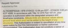
It's interesting that the LAANC documentation never mentions AGL in showing ceiling limits for authorizations. The authorization altitude has to be AGL, though. Otherwise, there would be no operations allowed at airports with an elevation of 400' or greater.
I would agree. Then the clearance is really for an altitude 160 ASL at the beach still in the control zoneIt's interesting that the LAANC documentation never mentions AGL in showing ceiling limits for authorizations. The authorization altitude has to be AGL, though. Otherwise, there would be no operations allowed at airports with an elevation of 400' or greater.
Ahh. I misunderstood your question.I would agree. Then the clearance is really for an altitude 160 ASL at the beach still in the control zone
My understanding is that the altitude limit is 100 feet AGL at all locations within the are covered by authorization. I don't think that the actual airport elevation is involved. I've deleted all the LAANC authorizations in my email records, so I don't know about the actual language. Do you have one? A web search doesn't turn up a sample authorization.
Eagle Eye 62
Well-Known Member
It's always based on AGL. I thought they pretty much drove that point home if you did any training before you took the Part 107 test.
Walleye Hunter
Well-Known Member
I'm new and learning here but I would expect it to be AGL at point of launch. What increments do they use when they issue the clearances?
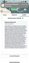
See the request approvals in the posts above where it states that altitude is absolute AGL.I'm new and learning here but I would expect it to be AGL at point of launch. What increments do they use when they issue the clearances?
For altitudes in Class B, C, D, and surface E that LAANC approval can be requested use an app like Air Control or go to the UAS Facilities Map ( ArcGIS Web Application ). Those are maximum altitudes allowed for LAANC approval (shown in feet AGL).
Similar threads
- Replies
- 6
- Views
- 417
- Replies
- 21
- Views
- 1K
- Replies
- 9
- Views
- 2K
- Replies
- 9
- Views
- 328
- Replies
- 30
- Views
- 1K


