DJI Mavic, Air and Mini Drones
Friendly, Helpful & Knowledgeable Community
Join Us Now

Litchi “above ground” checkbox

RetiredInFL

Very Large Member
Premium Pilot
Joined
Mar 1, 2020
Messages
400
Reactions
211
Age
76
Location
Central Florida
Must be my 72 yr old shrinking brain but I can’t CLEARLY understand the “above ground” checkbox on the waypoints and when or if I need it. Yes, I have read the manual. It just won’t register.
 
Let’s see if I get this right . ..
Litchi allows you to establish a waypoint in one of two ways.
1. Manually, in your route planning. You click on the screen where you want the WP and doctor the data accordingly.
2. On the fly. While flying and your wish to add a WP to your plan, you are able to add one in. The choice presented represents altitude of Tweety or relative to dirt.

My best guess! Haven’t played with it for a while.

BONUS: https://cdn.website-editor.net/0324...c89d/files/uploaded/Litchi%20Notes%20Rev2.pdf
Download this pdf file
 
The height is determined in relation the the HP ... so if the ground rises or gets lower later on in a mission the height for those waypoints always are in relation to the HP & that might not turn out in a good way as the distance to ground will differ if you don't manually take ground elevations into consideration when you set the waypoint heights.

In my example below the ground at waypoint 14 are 11,2m lower then at HP so if I had put in 30m for that waypoint the drone had been 41,2m above ground. But if I check the "above ground" box it will go 30m above ground ... heights stated above the waypoint itself is then the specified 30 first & then within parentheses the height above HP.

1587232486873.png

To get this to work I think you have to check in according to below in the general settings ...

1587232687362.png
 
  • Like
Reactions: RetiredInFL
The height is determined in relation the the HP ... so if the ground rises or gets lower later on in a mission the height for those waypoints always are in relation to the HP & that might not turn out in a good way as the distance to ground will differ if you don't manually take ground elevations into consideration when you set the waypoint heights.

In my example below the ground at waypoint 14 are 11,2m lower then at HP so if I had put in 30m for that waypoint the drone had been 41,2m above ground. But if I check the "above ground" box it will go 30m above ground ... heights stated above the waypoint itself is then the specified 30 first & then within parentheses the height above HP.

View attachment 99009

To get this to work I think you have to check in according to below in the general settings ...

View attachment 99010
Yes, absolute correct. I have not been out for a bit, but you are correct. Thank you for the clarification!
 
The height is determined in relation the the HP ... so if the ground rises or gets lower later on in a mission the height for those waypoints always are in relation to the HP & that might not turn out in a good way as the distance to ground will differ if you don't manually take ground elevations into consideration when you set the waypoint heights.

In my example below the ground at waypoint 14 are 11,2m lower then at HP so if I had put in 30m for that waypoint the drone had been 41,2m above ground. But if I check the "above ground" box it will go 30m above ground ... heights stated above the waypoint itself is then the specified 30 first & then within parentheses the height above HP.


To get this to work I think you have to check in according to below in the general settings ...


Thanks .... but I'm still dense. :) To make the answer clearer for my simple mind: In the "mission hub" in order for the AC to ALWAYS be 121 feet above the marked waypoint or ANY waypoint I have set regardless of anything else would I want the box checked or not checked ? :D :D


img upload


Thanks .... but I'm still dense. :) To make the answer clearer for my simple mind: In the "mission hub" in order for the AC to ALWAYS be 121 feet above the marked waypoint or ANY waypoint I have set regardless of anything else would I want the box checked or not checked ? :D :D


img upload


Yo would like to have the box checked as in your first pic ... if checked the AC will have an height of 121ft above ground (calculating in the web based ground elevation precisely there) but only 97ft above the HP. Those figures you have there indicates that the waypoint is placed where the ground is lower then where the HP are.
 
  • Like
Reactions: RetiredInFL
I would change your thinking about "xxx feet above the waypoint". The waypoint includes its height - it is a three dimensional co-ordinate.

I use Litchi's "Above Ground" nearly all the time in planning, for two simple reasons:
1. I would like not to hit the ground or any high obstructions (such as trees, mountains or buildings)
2. I intend to stay within legal flying frameworks - in my country 120 metres is the maximum height above ground

As an example of the first principle (not hitting anything):
Pentlands Hill Climb.jpg
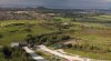
At its highest waypoint, the route rises 150+ metres from the starting point. I know that there are no trees higher than 30 metres here, and that there are no other aerial objects (such as pylons). Therefore I have set most of the mission at 40 metres, and at the furthest point (where there are no trees) the drone height goes down to 30 metres above ground level to capture a lower view of the ski slope. Litchi will do all the hard work to make sure the drone does not hit the ground. (The view is below)
Ski Slope View.jpg

As an example of the second principle (staying legally below 120 meters), I had planned a route from one hill to another, staying a "safe" 40m above me (i.e. not above ground, since the destination hill is lower than the start hill):
Level 30m Route.jpg
This 40 metre high route was probably "safe" for my drone, but breaks the Drone Code by the time it reaches the first line of trees. The ground drops over 100 metres, so I would be >20 meters above the maximum permitted altitude.

Instead, I set all waypoints to 40 metres above ground, resulting in:
Contoured 30m Route.jpg

The only "downside" to all this is that, without a doubt, your mission will take longer when changing its height during ground contouring. I am not convinced that Litchi is "aware" of how slow drones climb or descend, relative to their horizontal speed. However, Litchi over-estimates mission time anyway...
 

Attachments

  • Ski Slope View.jpg
    Ski Slope View.jpg
    1,010.3 KB · Views: 11
  • Like
Reactions: RetiredInFL
Thank you all. I think my brain had finally locked in on this. :D
 
  • Like
Reactions: Gindra
I generally keep my WPs established just above perceived tree level. When I reach a WP, I have the drone then perform the desired actions. At least, what is within LITCHI’s abilities. I have also purchased the AUTOPILOT. I have yet to use. I must decipher all the additional capabilities first. It looks promising for some of the shots I have in mind. In the meantime, I do learn a lot of the capabilities of LITCHI by searching the world map and checking the videos, settings, and drones used.
 
just one thing to add that i have discovered while trying to design a path up the mountain slope to cover a group of cabins and then continue up to hit a gazebo that overlooks the valley. the "above ground" setting works great, but my route kept stopping once it got above me at some point on the slope. I finally figured out that my max height setting was stopping the path, even though the drone was only 85' AGL. this was because my max setting is regarding takeoff ground level, not drone ground level. It would be nice to make a setting or checkbox that allows the max height to be regarding AGL instead of the takeoff location so you can program a path and not have to set a crazy 2000' height setting, when you really are only 100'-300' AGL.
 
  • Like
Reactions: Facherty and AZDave

DJI Drone Deals

New Threads

Forum statistics

Threads
131,280
Messages
1,561,622
Members
160,232
Latest member
ryanhafeman