DJI Mavic, Air and Mini Drones
Friendly, Helpful & Knowledgeable Community
Join Us Now

Litchi Problem: Drone Won't Fly Forward To RTH

That doesn't make sense because I took off from the "0" zone? And I have flown out here for years and again, why would the Fly app be OK with all of it and not Litchi?

It doesn't make sense to me either. Like I said, I'm surprised that you didn't get a warning from the control app. That location in the Sunnyvale Baylands County Park is definitely inside a 0' AGL block. Perhaps someone else has some insight.

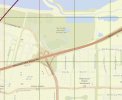
This is a detail from the FAA SUAS Facility Map.
Screenshot 2024-09-23 173958.jpg

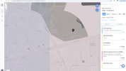
And here's the Aloft page with a marker dropped in the park near where you took off, indicating that it's in 0' AGL area.
Screenshot 2024-09-23 174159.jpg
 
It doesn't make sense to me either. Like I said, I'm surprised that you didn't get a warning from the control app. That location in the Sunnyvale Baylands County Park is definitely inside a 0' AGL block. Perhaps someone else has some insight.

This is a detail from the FAA SUAS Facility Map.

View attachment 177801

And here's the Aloft page with a marker dropped in the park near where you took off, indicating that it's in 0' AGL area.

View attachment 177802
Thanks for all your help :)
 
  • Like
Reactions: MS Coast
Thanks for all your help :)

I'm happy to offer what help I can give. There are some folks on the forum who seem to be very knowledgeable about airspace regulations. I'm hoping some of them will weigh in.

One thing that I've learned is that it's best to check locations with one of the FAA-approved apps and not rely on DJI Fly or Litchi to keep me legal. I'm interested in these airspace issues because of all the commercial airports and military installations near where I live and travel.
 
The real question still is why Litchi did that without warning especially since no nearby zones were restricted. (Check my map above)
Did you fly exactly the same route, at the same height with DJI Fly?
Or just somewhere in that general area?

The incident you describe is what you experience trying to fly through a geofenced barrier.
You can fly up/down/sideways, but not cross the invisible wall.
 
Did you fly exactly the same route, at the same height with DJI Fly?
Or just somewhere in that general area?

The incident you describe is what you experience trying to fly through a geofenced barrier.
You can fly up/down/sideways, but not cross the invisible wall.
Yes, I did, that's what is so frustrating

:)
 
Did you fly exactly the same route, at the same height with DJI Fly?
Or just somewhere in that general area?

The incident you describe is what you experience trying to fly through a geofenced barrier.
You can fly up/down/sideways, but not cross the invisible wall.

In addition to the in-flight issue, it's interesting that he was able to take off from a 0' AGL area without any warnings from FJI Fly or Litchi.
 
I think the important question is what database is DJI Fly and Litchi using to determine what zones are at what level? Should I take a screenshot off my ipad for the area in question to see what the apps think? I always turn off those layers when flying because they interfere with the map so much.
 
I think the important question is what database is DJI Fly and Litchi using to determine what zones are at what level? Should I take a screenshot off my ipad for the area in question to see what the apps think? I always turn off those layers when flying because they interfere with the map so much.
That doesn't really matter. Whatever they're using doesn't accurately reflect the FAA airspace regulations where you were flying. They're typically more reliable, but you can't rely on DJI Fly or Litchi to keep you within the regulations.

Check the flight area yourself using Aloft or one of the other FAA-approved apps that check compliance with the FAA regulations. The phone-based apps are convenient and straightforward to use.
Isn't the app(s) ultimately making the decision where the fence is, especially in my case I'm not using cellular or wifi at that spot. The apps have no way to actually check the FAA data, right?
 
Isn't the app(s) ultimately making the decision where the fence is, especially in my case I'm not using cellular or wifi at that spot. The apps have no way to actually check the FAA data, right?
Yes, the apps do have geo-fencing features. The airspace information is incorporated into the apps and there's no real-time interaction with remote sources. Updates are made periodically to the Fly Safe database. In the DJI Fly app, open the menu and select the About tab and scroll down to the update link.
 
Yes, the apps do have geo-fencing features. The airspace information is incorporated into the apps and there's no real-time interaction with remote sources. Updates are made periodically to the Fly Safe database. In the DJI Fly app, open the menu and select the About tab and scroll down to the update link.
My Lichi Geo fence map overly isn't working also.
 
The Fly app is software that resides on the phone. Separate updates are done for the firmware on the drone. Updating only the Fly app is not a problem.

The issue of the drone not flying forward may have been related to the obstacle avoidance system detecting something. Are you still seeing the problem?
I never use obstacle avoidance
 

DJI Drone Deals

New Threads

Forum statistics

Threads
135,559
Messages
1,607,365
Members
164,000
Latest member
DougalMacaroon
Want to Remove this Ad? Simply login or create a free account