DJI Mavic, Air and Mini Drones
Friendly, Helpful & Knowledgeable Community
Join Us Now

LOSS of CONTROL OVER WATER **EXPLAINED**

I have frequently flown over water to capture video of friend who waterski. I began with the Mavic Pro and never had any issue with flying between 10 - 15 feet above the subject.
Mavic 2 Zoom performed just as well as the original Mavic Pro.
But when I began to use the Mini 2, I noticed a big change in how it performed, based upon the need to accelerate in Sport mode. Full power acceleration causes the drone to tilt forward to increase speed. This forward tilt results in minor drop in altitude which can be viewed on the OSD.
The Mini 2 however showed a much greater drop in altitude, to the point where I must start with an altitude of at least 20 feet to maintain a margin of safety not to drop down to the surface of the water.
Anyone care to comment on the reasons the Mini 2 appears to drop more than the MP or M2Z?
 
Is it possible that, over running water like a fast moving creek with ripples, the drone thinks it's flying forward and tries to back up to maintain a hover?
That might happen in opti mode, but not if the FC has a GNSS solution.
I recently had my first experience with that while flying my Mini down into a narrow river canyon. Like eEridani said, when looking straight down into the canyon it's difficult to visually judge the height of the drone above the river's surface. So I was relying on the camera view to position the drone where I wanted it.

I was flying off a 450 foot sheer cliff down to the river below. Seeing the drone wasn't an issue - if I ignored the vertigo - but altitude over the water was impossible to judge looking almost straight down.
With the camera aimed straight down I could see where the river current was being funnelled between two large rocks. I wanted the drone to hover centred above that point. But then suddenly the drone started backing downstream all by itself. Yikes!

At first I thought the drone was being carried away by strong wind created by turbulence close to water's surface. But thinking about it later, it all makes sense now. The GPS reception was insufficient down there between the steep rock walls. So the Mini was instead relying on its optical sensor for position hold in hover whenever the control sticks were centred. It fixated on the moving foam on the water's surface and very accurately tracked that downstream. Cool.

No harm done. I saw it moving away all by itself. I just needed to give it some stick input to move it back where I wanted it to go. It would only have been an issue if I hadn't been paying attention, or looked away for some time, then been surprised when the drone was no longer where I thought it should be.

It's only a potential issue when hovering with sticks centred. The drone was otherwise perfectly controllable. If you're out in the open with good GPS lock for position hold, this would never be an issue at all.

In this particular instance there were no problems at all with altitude holding, but I did have an unrelated curious moment a little while later on the same flight.
 
  • Like
Reactions: thispilothere
When flying low over water I may occasionally glance at my altitude, but my primary reference is visual on the drone if it's close enough or via the tablet if I'm out of line of sight. I also fly with sensors off. It's not a complex issue, just don't fly your drone into the water 😁🐬 ...
 
  • Like
Reactions: Meta4
Mini 1 was my only ‘over-water’ problem drone. Refused to hover and hold position without wanting to go swimming. It was somewhat helped by a firmware update but sold it to a landlubber. Have an A2 with rescue jacket now so no more pucker flying over water which is mostly. And thankfully, it doesn’t like to swim. Even my Phantoms will occasionally drift down in calm water hovering. Just always watch your screen and drone at the same time, especially low over water. Out of sight or looking up and down is asking for trouble.
 
@sar104 : in your experience have you discovered differences between the ultrasonic altitude versus infrared altitude sensors?

DJI drones do not use the downward sensors for altitude control - it uses the barometer.

Anyone who says their drone just randomly dove into the water, 99% of the time it is user error.
 
  • Like
Reactions: db4476
Such funny response from folk just because I included a couple of my over-the-water-oddness experiences to this thread. Does everyone here look for things to bash other people about?

In all cases I mentioned - there was no loss, not actual dangerous condition - just some notable control weirdness when near water. And since the DJI manual says to be careful over water, well, the weirdness is probably expected, no?
 
Does everyone here look for things to bash other people about?
Sometimes it does look like that. But I think most people would just like to understand what really happened and why. Too often people post an opinion or conclusion that's not based on actual fact, and that ends up being repeated by enough others until it becomes accepted truth. There's a lot of misinformation circulating about the VPS system, and it ends up being blamed for all sorts of things that just aren't possible.
 
  • Like
Reactions: umanbean and Meta4
Yeah - there are a few in this thread confidently professing their ignorance. But you can only ignore so many before the forum is useless.
 
DJI drones do not use the downward sensors for altitude control - it uses the barometer.

Anyone who says their drone just randomly dove into the water, 99% of the time it is user error.

It depends what you mean by "altitude control". In normal flight the primary altitude data come from the IMU accelerometers detecting vertical motion, with the barometer factored in at lower gain to compensate for inertial sensor drift and bias. But close to the ground (or water) the VPS system is used to prevent flying into the ground and, for example, takes over to control descent speed on landing.
 
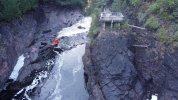
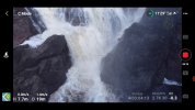
I was flying from this observation platform, standing at the railing to watch the drone as I lowered it down to near the water's surface. You can see the way the foam pattern sweeps over to the left and then speeds up through a narrow gap.
1.jpg

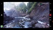
Here's the view from the drone, with it hovering -9.1m (30ft) below me. It's got 9 satellites at this point.
2.jpg


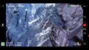
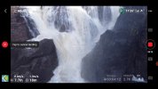
I rotated the camera to face down, and moved the drone slightly left to get it centred over the current, and then it started accelerating downstream on its own. Note only 8 satellites now.
3.jpg


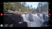
I was confused for a moment, because I'm pretty sure it did that all by itself. When it reached this point it stopped. That was either because it now was seeing the whipped up white water in a relatively static position, compared to the rapidly moving black water, or this was the moment I gave it some forward stick to stop it from backing up any further. In any case, it was an unexpected moment. :oops:
4.jpg

No problem with holding height. I believe it was just insufficient GPS lock and the optical sensor trying to maintain position over a moving surface.
 
  • Like
Reactions: thispilothere
In this particular instance there were no problems at all with altitude holding, but I did have an unrelated curious moment a little while later on the same flight.
This one I'm not sure about at all. Too much risky flying here...

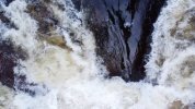
I had enough higher altitude shots, so then I did that low shot over the water, which already scared me when it started drifting downstream by itself. But then I did some closer low shots of the waterfall, like this, and slowly rising up.
5.jpg

Okay that's enough. Time to bring it back and land it. No longer looking at the screen, I'm looking right at the drone as I'm lowering it and bringing it back towards me. Note at this point the drone is still +7.7m above me (25ft) and 19m (62ft) away from me.
6.jpg

A second later, I'm still looking at the drone when I hear a beeping alarm and the drone starts sinking! Wait, what, why? What's THAT now?

Is that a low battery RTH? No, I still have just under half a battery left. 🤔 And, since the drone is now within 20m of the Home position, it's not going do a RTH, it's just going to land right where it is now, into the river! Nooooooo!
7.jpg


Note the storage timer in the bottom right. It took me 4 seconds to respond to this emergency as I watched the Mini descend 4.6m (15ft) in Auto-Landing mode,dropping from 7.7m down to 3.1m. I tapped the red X to cancel landing, and gave it plenty of up throttle input to stop the descent.

Remember, the drone was launched from the observation platform that's at least 9m above the water surface. So at the 7.7m height shown in the display, it was at first about 17m above the water. And I stopped the auto-landing when it was still 3m above my head, so a good 12m above the water.

Four seconds of panic was plenty enough time to safely stop it from landing in the water. But what the heck just happened there?
8.jpg


Here's the Phantomhelp logviewer link:
DJI Flight Log Viewer - PhantomHelp.com

At the 4m 1s time mark the VPS altitude suddenly comes alive reporting 3.6ft height above ground, while it's still 27.9ft above me. At 4m 3.2s, as I'm descending at 25m above me, the VPS is suddenly reporting 2ft AGL and then it goes into "Forced Landing".

Bizarre. Was there mist on the sensor? Or was the drone really only 2ft above something? Even so, it should only go into auto-landing if I'm holding the throttle stick full down. I was descending, but not at max down throttle.

At the end of the flight I landed the Mini on my hand. The last three entries in the log show Forced Landing from a height of 1ft above my hand, with the throttle position indicator turned RED showing full down on the stick.

I'm confused.
 
At the 4m 1s time mark the VPS altitude suddenly comes alive reporting 3.6ft height above ground, while it's still 27.9ft above me. At 4m 3.2s, as I'm descending at 25m above me, the VPS is suddenly reporting 2ft AGL and then it goes into "Forced Landing".

I'm confused.
I'd hazard a guess you were feeling the blast of the water moving the air around, and where you launched was a bit more sheltered. The updrafts around you when landing were probably messing with the altitude readings in the IMU.

I'll add, I've had my Air 2 start autolanding at strange times. I was always descending, but not at maximum stick (though, tbh, I may have hit the stick limit at some point then backed off). Just a simple 'let's descend a few feet for a better camera angle,' and while most of these events were over water, a couple have been over land. Almost all happened after switching control modes while in flight, with any time in sport mode almost certain to cause anomalies after switching back to p-mode (this usually ends with hand catch practice).
 
Last edited:
Does everyone here look for things to bash other people about?
Zbip was clarifying your misunderstanding.
That's not bashing.
In all cases I mentioned - there was no loss, not actual dangerous condition - just some notable control weirdness when near water. And since the DJI manual says to be careful over water, well, the weirdness is probably expected, no?
No ... there's no reason to expect weirdness near water.
But if you fly in a location with poor GPS reception due to nearby steep terrain and the VPS also has difficulty with horizontal position holding, you might expect things won't be as you are used to.
 
Is it possible that, over running water like a fast moving creek with ripples, the drone thinks it's flying forward and tries to back up to maintain a hover? This has happened several times with my MA2. It backed up about 6-9 feet before I took the controls and forced it forward again.
Only time I have had an issue flying over water of any type - creek / river / waterfalls (so moving water) is in ATTI mode. Being close to moving water does create some wind effect and in ATTI - the drone will move even with low wind speeds.

Never had issues when I had GPS signal with drone doing anything uncommanded (on its own).

When flying low over water - say 10 ft or so - I'm WATCHING the drone - not the camera / screen except for maybe a very brief 1-2 second glance to make sure I've got the camera focusing on what I want to be shooting. Relying on the camera / screen and flying low over anything is a recipe for disaster IMHO.

So, to me - LOS is critical to keep the drone safe from any obstacle (water, trees, etc.). Most time I'm filming water shots, "I" want to be at water level; not high on a bank so my depth perception is not affected; as it typically will.

Water is simply another obstacle in a drone pilot's wheelhouse to learn to fly safely in. No different than flying in and around trees and other solid objects that will make your day go bad should you impact any of them.
 
The IR sensors fare worse though, because they are not optimized for specular reflecting surfaces.
I confess, I had to look up the definition of "specular". 🤓

Specular reflection is what you get from a perfectly flat mirror-like surface, whereas diffuse reflection is scattered from a rough surface.

More confessions, the following is all conjecture and just my understanding of how these things work. If I'm out to lunch on this, PLEASE correct me. For one thing, I have no idea how focused or wide-angle the outgoing beam signal is.

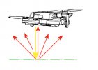
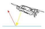
The infrared sensor on my Mini, like the ultrasonic sensor on my older Phantom 3, sends an outgoing signal (yellow) that bounces back (red) from the reflecting surface up to the receiver on the drone. The time taken between the outgoing signal and bounced return tells the VPS system how high the drone is above the reflecting surface.

With a diffuse reflection the drone is guaranteed to receive at least some reflection.
Diffused.jpg
But with a specular reflection off a mirror surface the reflection may miss the drone altogether, depending on the drone's attitude, height, speed, etc.
Specular.jpg
If the signal isn't bounced back at all, i.e. completely absorbed, or the drone is too high and the reflecting surface is out of range, then the VPS system cannot measure the drone's height.

But none of that explains how the VPS system could ever cause the drone to crash into water.
It depends what you mean by "altitude control". In normal flight the primary altitude data come from the IMU accelerometers detecting vertical motion, with the barometer factored in at lower gain to compensate for inertial sensor drift and bias. But close to the ground (or water) the VPS system is used to prevent flying into the ground and, for example, takes over to control descent speed on landing.
Exactly.

The ultrasonic or infrared height measurement of the VPS system will only ever prevent the drone from descending into water or into the ground.

With my Mini, if I hold the throttle stick down (not FULL down), the drone will descend only so far before hovering over the ground (approx 1/2 meter). Or, if it encounters an obstacle during flight, like sticking my hand under it, the Mini will automatically jump up to ensure at least 1/2 meter ground clearance. The VPS sensor prevents it from descending any closer. If I want it to go lower than that and land, I need to hold the throttle stick full down to initiate the auto-landing process.

When flying over water, if the ultrasonic or infrared sensors are working properly, you should be similarly prevented from descending any closer than 1/2 meter to the water's surface. But, you should not commit to that working properly all the time.

If the sensors are not working, for whatever reason, then you can fly your drone into the water. For example, some people will tell you the sensors can see right through the water's surface to the bottom of the pond. In that case, the VPS system may incorrectly be measuring it's height from the bottom of the pond, rather than the water's surface. If it's reading an incorrect height like this, it can't prevent you from sinking the drone.

Lots of people will coach you to always disable the VPS system (or cover the sensors with tape) whenever you plan to fly over water, as this will somehow ensure the VPS system cannot cause the drone to crash into the water. The only thing accomplished by that (with respect to height measurement) is that it ensures the VPS system will never be able to prevent you from crashing your drone into the water's surface.
 
Only time I have had an issue flying over water of any type - creek / river / waterfalls (so moving water) is in ATTI mode. Being close to moving water does create some wind effect and in ATTI - the drone will move even with low wind speeds.
The optical sensor of the VPS system is a different story.

Moving the control sticks is always the primary mode of control. It's just in hover, with sticks centred, that there's a significant difference between GPS, Opti, or Atti modes.

With good GPS lock, the drone will brake to a halt and hold a steady position whenever the control sticks are released and centred.

In the absence of sufficient GPS lock the drone will instead rely on the optical sensor of the VPS system. Its camera detects patterns on the ground to hold a fixed position when in hover. If that detected pattern is moving, like ripples on the water's surface, or a leaf floating downstream, then the optical sensor may track and follow that movement.

If there is no detectable pattern, i.e. uniformly smooth featureless surface, or it's too dark for the camera to see anything, or the drone is too high, then the camera cannot obtain an optical lock and it won't be able to hold a fixed position in hover.

Or if it's a perfectly smooth specular mirror-like surface, the VPS camera might only see the drone itself reflected in the surface. In that case it may establish a good optical lock on itself and can't tell that it's actually moving.

In the absence of both GPS lock and Optical lock, the drone defaults to Atti mode. This only means it cannot hold a fixed position while hovering, and it cannot brake to a full stop whenever the control sticks are centred. You still have full control on its movements, just that it won't hold a fixed position when the sticks are centred. In hover it's free to drift with any wind, and will drift from its own turbulence if it's within a confined space.

The Optical component of the VPS system might not be able to prevent the drone from drifting into an overhanging tree branch, but otherwise it cannot cause the drone to descend into water.
 
  • Like
Reactions: Meta4
This one I'm not sure about at all. Too much risky flying here...

I had enough higher altitude shots, so then I did that low shot over the water, which already scared me when it started drifting downstream by itself. But then I did some closer low shots of the waterfall, like this, and slowly rising up.
View attachment 136157

Okay that's enough. Time to bring it back and land it. No longer looking at the screen, I'm looking right at the drone as I'm lowering it and bringing it back towards me. Note at this point the drone is still +7.7m above me (25ft) and 19m (62ft) away from me.
View attachment 136158

A second later, I'm still looking at the drone when I hear a beeping alarm and the drone starts sinking! Wait, what, why? What's THAT now?

Is that a low battery RTH? No, I still have just under half a battery left. 🤔 And, since the drone is now within 20m of the Home position, it's not going do a RTH, it's just going to land right where it is now, into the river! Nooooooo!
View attachment 136160


Note the storage timer in the bottom right. It took me 4 seconds to respond to this emergency as I watched the Mini descend 4.6m (15ft) in Auto-Landing mode,dropping from 7.7m down to 3.1m. I tapped the red X to cancel landing, and gave it plenty of up throttle input to stop the descent.

Remember, the drone was launched from the observation platform that's at least 9m above the water surface. So at the 7.7m height shown in the display, it was at first about 17m above the water. And I stopped the auto-landing when it was still 3m above my head, so a good 12m above the water.

Four seconds of panic was plenty enough time to safely stop it from landing in the water. But what the heck just happened there?
View attachment 136161


Here's the Phantomhelp logviewer link:
DJI Flight Log Viewer - PhantomHelp.com

At the 4m 1s time mark the VPS altitude suddenly comes alive reporting 3.6ft height above ground, while it's still 27.9ft above me. At 4m 3.2s, as I'm descending at 25m above me, the VPS is suddenly reporting 2ft AGL and then it goes into "Forced Landing".

Bizarre. Was there mist on the sensor? Or was the drone really only 2ft above something? Even so, it should only go into auto-landing if I'm holding the throttle stick full down. I was descending, but not at max down throttle.

At the end of the flight I landed the Mini on my hand. The last three entries in the log show Forced Landing from a height of 1ft above my hand, with the throttle position indicator turned RED showing full down on the stick.

I'm confused.
Would your take off point have metal that may not have provided GPS home point accuracy?
 

DJI Drone Deals

New Threads

Forum statistics

Threads
134,485
Messages
1,595,523
Members
163,013
Latest member
GLobus55
Want to Remove this Ad? Simply login or create a free account