

Apologies, I hadn't realised that AirData had a different version. Here's the original (changed extension from CSV to enable upload).OK - so this is still not the original Litchi csv file - it's the csv file that you downloaded from AirData after uploading the original Litchi csv. I need the original.

You are using an out of date browser. It may not display this or other websites correctly.
You should upgrade or use an alternative browser.
You should upgrade or use an alternative browser.
Lost Mavic Air
- Thread starter IanChap
- Start date
The log broadly agrees with your recollection, and the problem is that your suspicion at the end is correct - it was heading away from you. The problem is that at 322 s the aircraft entered RTH, and rotated to face north (towards the home point). 50 seconds later you cancelled RTH and applied rudder that rotated the aircraft back to a southerly heading and applied full forward elevator.

At some point between 380 and 408 seconds (around 395 s based on altitude extrapolation, but it was during a downlink signal loss), autolanding was triggered due to low battery, and it started to descend. You maintained full forward elevator and so it continued south while descending until downlink was lost at 505 seconds. If uplink was lost at the same time then it would have stopped and descended approximately vertically to that last recorded position. You checked that location, I think, and so it probably continued south while descending for an unknown distance, though probably not far. I suggest checking its last recorded track south from the last recorded point to the ground intersection point - the red line out to the red circle intersection:

At some point between 380 and 408 seconds (around 395 s based on altitude extrapolation, but it was during a downlink signal loss), autolanding was triggered due to low battery, and it started to descend. You maintained full forward elevator and so it continued south while descending until downlink was lost at 505 seconds. If uplink was lost at the same time then it would have stopped and descended approximately vertically to that last recorded position. You checked that location, I think, and so it probably continued south while descending for an unknown distance, though probably not far. I suggest checking its last recorded track south from the last recorded point to the ground intersection point - the red line out to the red circle intersection:
Thank-you for your analysis.
I've been there again this afternoon, looking around the last recorded position. It's pretty thick deciduos woodland, and I'm far from confident I'd see it if I was right beneath. But I do have a tree-surgeon friend who's going to climb in that spot tomorrow morning!
So what I'm viewing in AirData may not be correct? In particular it's showing it still at the last point at 1010s - but this did seem very suspicious to me as the location and altitide haven't changed whatsoever. And your graph seems to agree. But I'm puzzzled why I have a log entry after so long?
I'll walk the extrapolated path you show, but I'm not optimistic I'll find it unless it landed in the field.
Does the log file indicate how accurate the GPS location was? And one other question - does the ground intersection you show take into account the terrain, or is that assuming level ground? It's quite hilly there - the field the red line crosses being a low point. In fact, even from a quick look pon GE, I think if it continued it's rate of descent, it wouldn't be that far past the field - which is good.
Thanks again.
Thank-you for your analysis.
I've been there again this afternoon, looking around the last recorded position. It's pretty thick deciduos woodland, and I'm far from confident I'd see it if I was right beneath. But I do have a tree-surgeon friend who's going to climb in that spot tomorrow morning!
So what I'm viewing in AirData may not be correct? In particular it's showing it still at the last point at 1010s - but this did seem very suspicious to me as the location and altitide haven't changed whatsoever. And your graph seems to agree. But I'm puzzzled why I have a log entry after so long?
I'll walk the extrapolated path you show, but I'm not optimistic I'll find it unless it landed in the field.
Does the log file indicate how accurate the GPS location was? And one other question - does the ground intersection you show take into account the terrain, or is that assuming level ground? It's quite hilly there - the field the red line crosses being a low point. In fact, even from a quick look pon GE, I think if it continued it's rate of descent, it wouldn't be that far past the field - which is good.
Thanks again.
I don't think those last two data points are real - the data are identical to the data 5 minutes previously, including speeds, descent rate, battery etc. Not possible.
The GPS coordinates should be good to a few meters - the aircraft had 17 satellites locked.
Good point on the terrain heights - I didn't check those because it looked flat. The ground elevation at the last point is around 145 m, and taking that into account it's not going to have made it past the open field.

I can't get a decent GPS signal in the woods, seems to wander by 5-6m. But with a combination of optical and GPS surveying equipment (accuracy ~15mm!) I have, I could mark out the precise final recorded location before my guy climbs the appropriate tree.
But, to me it now makes more sense that it continued it's descent path - quite possibly into the light green trees on the south side of the field, which I think are quite tall. So will check that and the rest of the extrapolated path first.
After I first visited the site, I very briefly got a connection somewhere I estimate to be in the white rectangular area, probably around 45 minutes after I lost it. I didn't take much notice, as I thought I'd connect again - but I think the battery must have been about to die.
How long would you expect a battery to last after an emergency (low battery) landing?
Map here
I can't get a decent GPS signal in the woods, seems to wander by 5-6m. But with a combination of optical and GPS surveying equipment (accuracy ~15mm!) I have, I could mark out the precise final recorded location before my guy climbs the appropriate tree.
But, to me it now makes more sense that it continued it's descent path - quite possibly into the light green trees on the south side of the field, which I think are quite tall. So will check that and the rest of the extrapolated path first.
After I first visited the site, I very briefly got a connection somewhere I estimate to be in the white rectangular area, probably around 45 minutes after I lost it. I didn't take much notice, as I thought I'd connect again - but I think the battery must have been about to die.
How long would you expect a battery to last after an emergency (low battery) landing?
Map here
Not long - it will run for about 3.5 hours with motors off from 100%, so maybe 30 minutes max from 15%. The marked area seems a little off track to the west, but this is all guesswork to some extent once the log stops.
It was very brief, and as I say I reckon it was just dying. It certainly was not much more than 30 mins after it was lost. But it does prove it was in that valley. The white rectangle is just where I estimated I walked when I got the connection, so may not be that near the aircraft.Not long - it will run for about 3.5 hours with motors off from 100%, so maybe 30 minutes max from 15%. The marked area seems a little off track to the west, but this is all guesswork to some extent once the log stops.
It was very brief, and as I say I reckon it was just dying. It certainly was not much more than 30 mins after it was lost. But it does prove it was in that valley. The white rectangle is just where I estimated I walked when I got the connection, so may not be that near the aircraft.
Well at least you know which haystack to search...
Spent 4-5 hours yesterday with assistance looking first in the field, and then in woods to the south and north. Trouble is, the trees are fairly dense, and the undergrowth is also dense (brambles etc), and some of the ground quite steep. Had my tree-surgeon friend climb very nearly to the top of the tree at the final log file point, and worryingly I could not see him (even when he spoke!) so I really don't think there's much chance of spotting a black Mavic Air if it's anywhere near the top of a densely-foliated tree.
What I'd really like to know, is what the drone will most likely have done when it lost signal (flying FPV Litchi). Will it have immediately stopped and hovered? Descended vertically? Continued on it's current path and/or rate of descent?
I have (for now) estimated the heights of the trees on both sides of the field, and plotted the heights in GE. If it continued it's downward slope, it's obvious it will have cleared the trees on the north side of the field, but touch-and-go whether it would have made it over those on the south side. If it's suggested that it will have continued it's current path, I'll go and measure the ground level and tree height more accurately at the point the drone would have crossed. No sign of it in these trees though, looking from the field side with binoculars.
The file attached is a ZIP, simply change the extension to KMZ to view in Google Earth.
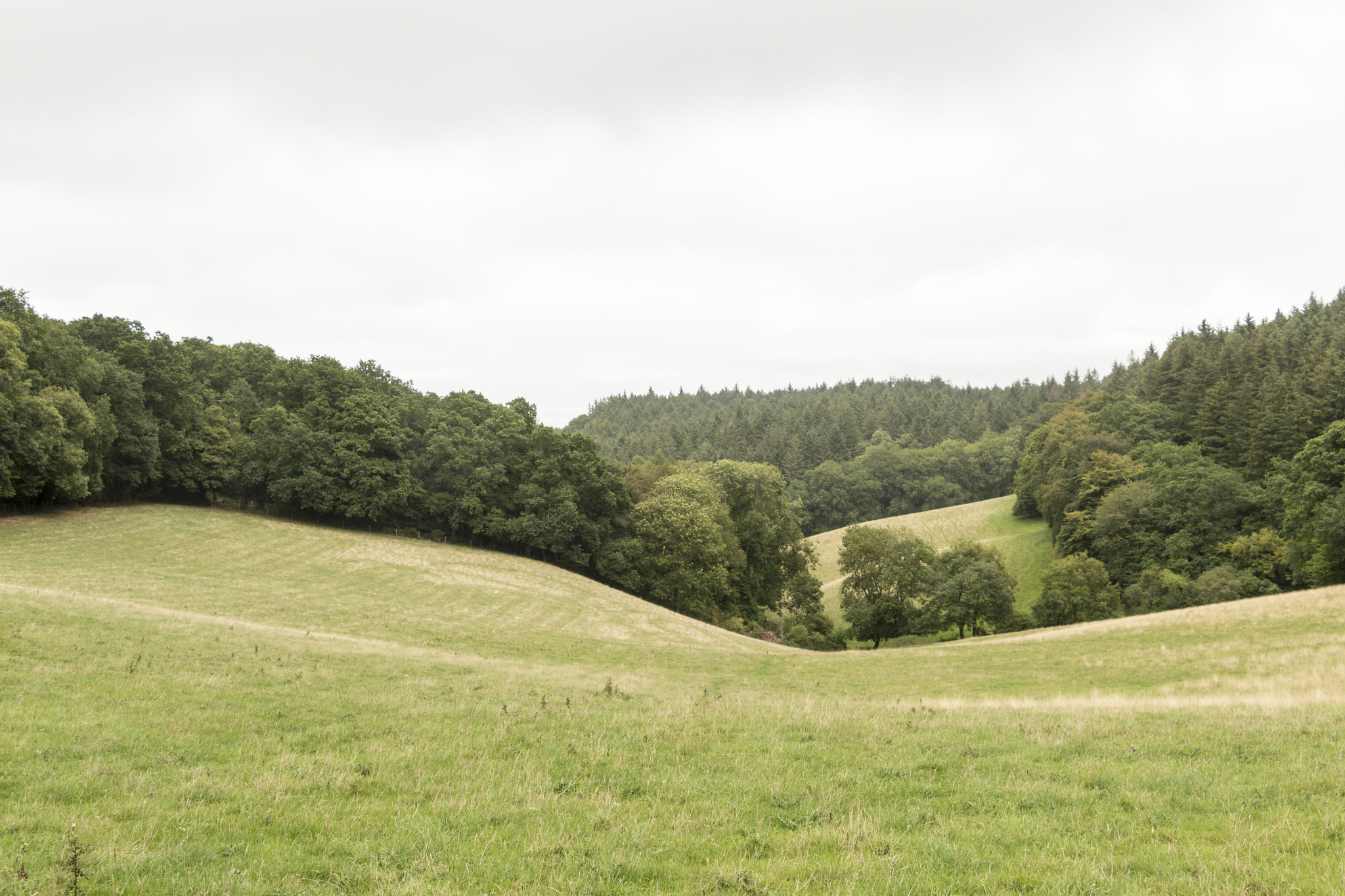
Here's a view from the west (location of camera shown in GE file):
What I'd really like to know, is what the drone will most likely have done when it lost signal (flying FPV Litchi). Will it have immediately stopped and hovered? Descended vertically? Continued on it's current path and/or rate of descent?
I have (for now) estimated the heights of the trees on both sides of the field, and plotted the heights in GE. If it continued it's downward slope, it's obvious it will have cleared the trees on the north side of the field, but touch-and-go whether it would have made it over those on the south side. If it's suggested that it will have continued it's current path, I'll go and measure the ground level and tree height more accurately at the point the drone would have crossed. No sign of it in these trees though, looking from the field side with binoculars.
The file attached is a ZIP, simply change the extension to KMZ to view in Google Earth.
Here's a view from the west (location of camera shown in GE file):
Attachments
Spent 4-5 hours yesterday with assistance looking first in the field, and then in woods to the south and north. Trouble is, the trees are fairly dense, and the undergrowth is also dense (brambles etc), and some of the ground quite steep. Had my tree-surgeon friend climb very nearly to the top of the tree at the final log file point, and worryingly I could not see him (even when he spoke!) so I really don't think there's much chance of spotting a black Mavic Air if it's anywhere near the top of a densely-foliated tree.
What I'd really like to know, is what the drone will most likely have done when it lost signal (flying FPV Litchi). Will it have immediately stopped and hovered? Descended vertically? Continued on it's current path and/or rate of descent?
I have (for now) estimated the heights of the trees on both sides of the field, and plotted the heights in GE. If it continued it's downward slope, it's obvious it will have cleared the trees on the north side of the field, but touch-and-go whether it would have made it over those on the south side. If it's suggested that it will have continued it's current path, I'll go and measure the ground level and tree height more accurately at the point the drone would have crossed. No sign of it in these trees though, looking from the field side with binoculars.
The file attached is a ZIP, simply change the extension to KMZ to view in Google Earth.
Here's a view from the west (location of camera shown in GE file):
It was autolanding so, on loss of uplink, it will have descended vertically.
So if I was to accurately mark the final log location, it ought to be within a couple of metres, i.e. it would have stopped horizontal movement immediately?
Yes - if it lost uplink at exactly the same time that you lost downlink. But likely it would be at least a few meters further along. Probably not far though - it was nearly down.
ryanolivas
Well-Known Member
- Joined
- Apr 2, 2018
- Messages
- 320
- Reactions
- 116
- Age
- 36
Think of inversting a tracking device so you that you will have 2 options The buil-in GPS and The GPS from your tracking deviceAnd generally, how do we find a flyaway, as surely the log file will only be as up to date as when signal was lost? Extrapolating I guess?
WOW!!! 144 days later, I've today retrieved it!
Turns out it had flown on another 46 metres past the last logged location, and was less than a metre off-centre from the projected flight path (that's halfway down the woods, for anyone who knows the location).
I spent a lot of time looking initially, before waiting until December for the oak trees to fully shed their leaves (although there was a lot of holly mixed in) and having another go. The insurance (for damage, not total loss) expires next month, so time was of the essence. But it had become more of a technical challenge and treasure-hunt than anything else.
I searched high and low visually,
Had a tree surgeon climb a couple of high trees,
Modelled in 3D CAD,
Videoed the tops of the trees from all angles using my replacement (M2P),
Made Drone Deploy surveys,
Went over the ground with a metal detector,
And finally yesterday, on an area so thick with brambles that I couldn't reach it with the metal detector, I sent my M2P slowly over, filming.
It wasn't until last night, when I went over this footage, I spotted something that looked like a stone underneath a fallen tree branch. It was probably nothing - but sure enough, popped up there today and there it was, lying fairly well hidden on it's back! It's currently having a rest for a few days in my airing cupboard. Be interesting to see if it works.
Thanks to all who helped, sar104 in particular.
Some photos here
I'd like to leave it a few days to dry and then power it up. Is there likely to be more log info there than on my phone? And am I going to invalidate insurance (it's UK Heliguy, but similar to DJI Refresh I think) if turning on then blows it?
Last edited:
WOW!!! 144 days later, I've today retrieved it!
Turns out it had flown on another 46 metres past the last logged location, and was less than a metre off-centre from the projected flight path (that's halfway down the woods, for anyone who knows the location).
I spent a lot of time looking initially, before waiting until December for the oak trees to fully shed their leaves (although there was a lot of holly mixed in) and having another go. The insurance (for damage, not total loss) expires next month, so time was of the essence. But it had become more of a technical challenge and treasure-hunt than anything else.
I searched high and low visually,
Had a tree surgeon climb a couple of high trees,
Modelled in 3D CAD,
Videoed the tops of the trees from all angles using my replacement (M2P),
Made Drone Deploy surveys,
Went over the ground with a metal detector,
And finally yesterday, on an area so thick with brambles that I couldn't reach it with the metal detector, I sent my M2P slowly over, filming.
It wasn't until last night, when I went over this footage, I spotted something that looked like a stone underneath a fallen tree branch. It was probably nothing - but sure enough, popped up there today and there it was, lying fairly well hidden on it's back! It's currently having a rest for a few days in my airing cupboard. Be interesting to see if it works.
Thanks to all who helped, sar104 in particular.
Some photos here
I'd like to leave it a few days to dry and then power it up. Is there likely to be more log info there than on my phone? And am I going to invalidate insurance (it's UK Heliguy, but similar to DJI Refresh I think) if turning on then blows it?
Glad to hear that you found it. That location is certainly consistent with the predicted end point for the flight, but I'm impressed that you managed to find it in that kind of terrain.
There are DAT files on the aircraft but on the Mavic Air they are encrypted so we can't actually read them.
Having gone through so many scenarios in my head whilst searching, and given that it's not going to be possible to extract and read any more info, I'm trying to estimate what actually did happen (apart from someone pushing their luck too far regards battery!). Principally to satisfy my curiosity, but also so I know what's likely to have happened should I come across this situation again (hopefully not created by me).
So here's a scaled section. Is it likely that it descended via path A, B, or C? I would have thought A is highly unlikely, B suggests more of a freefall consistent with losing power in the air (speed is shown at 19mph at last logged point), and C would perhaps be hovering until a controlled auto-landing. But I'm guessing. What do you think?


So here's a scaled section. Is it likely that it descended via path A, B, or C? I would have thought A is highly unlikely, B suggests more of a freefall consistent with losing power in the air (speed is shown at 19mph at last logged point), and C would perhaps be hovering until a controlled auto-landing. But I'm guessing. What do you think?
Having gone through so many scenarios in my head whilst searching, and given that it's not going to be possible to extract and read any more info, I'm trying to estimate what actually did happen (apart from someone pushing their luck too far regards battery!). Principally to satisfy my curiosity, but also so I know what's likely to have happened should I come across this situation again (hopefully not created by me).
So here's a scaled section. Is it likely that it descended via path A, B, or C? I would have thought A is highly unlikely, B suggests more of a freefall consistent with losing power in the air (speed is shown at 19mph at last logged point), and C would perhaps be hovering until a controlled auto-landing. But I'm guessing. What do you think?
View attachment 58248
View attachment 58249
Almost certainly C.
Hopefully none of the electronics got wet. If they did get wet it won’t help waiting for it to dry. They will eventually corrode and you’ll have an out of control drone on your hands. Had something like that happen with an R/C. Worked at first then started doing crazy stuff not long after.
Similar threads
- Replies
- 1
- Views
- 768
- Replies
- 118
- Views
- 6K
- Replies
- 7
- Views
- 1K


DJI Drone Deals
New Threads
-
 Last Week's Most Popular Topics (January 31, 2026)
- Started by msinger
- Replies: 0
-
 How to Protect and Extend the Life of your Equipment in 2026 (By Timothy Brazzel)
- Started by The Droning Company
- Replies: 1
-

-
Navigating the Invisible (By Chris 'The Drone Geek' Fravel)
- Started by The Droning Company
- Replies: 0
-
Forum statistics
