DJI Mavic, Air and Mini Drones
Friendly, Helpful & Knowledgeable Community
Join Us Now

Lost my M2P - is it possible to buy just the aircraft?

WOW - awesome analysis job! Yes, you are absolutely correct about WP5 area. I was attempting to minimize the camera down pitch for the view thus flying somewhat low around that rock bump. I just got back from doing a bit more "looking around" and noticed that it is much more prominent on the south-east edge than the google image would suggest. It turns out with the rounded flight path it ended up with a 10' deficit right as it met the bump. So, while I could not see and/or retrieve the drone, it has got to be down below (about 400' - 600') most likely shattered into a million pieces.

Another question: How are you doing the virtual flight? All I used for this is the 3D KML with GoogleEarth Pro - and where did that lead me :rolleyes:

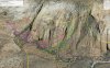
Yes, I was also going to say that there was not enough room just after WP 5 (only some meters away and/or over the cliff).
A great care is to be taken with the elevations displayed in Google Earth, particularly in mountainous areas. Elevations are most of time a mean of a minimum 10X10 m square area (i.e. 100 square meters). This means that along steep slopes Google estimations can be completely wrong (by 20 or 30m at a precise point, sometimes). In addition Litchi often uses old google maps which are far less accurate than recent Google Earth maps. And last but not least, both old and recent maps do not take into account the vegetation. When flying at only 3 or 4m above ground, even a bush can be fatal, specially when paning such as you did after WP 5 (obstacle avoidance does not work).

Virtual flight can be performed in Google Earth by using Virtual Litchi Mission from Namirda. Have a look here : Virtual Litchi Mission

Sorry for your loss, anyway...

P.S. VLM also displays what Namirda called "Diagnostics" This show that at WP 5 your altitude relative to ground is only 18m, decreasing rapidly jut after this waypoint to what I estimate around 5m. With respect to the imprecision of Google Earth elevations along this kind of slope and to the margin of error of the drone in both its altitude and position instantaneous mesurements, this is not secure at all.MISSION USA.JPGMISSION USA.JPGMISSION USA.JPG
 
Last edited:
Looks like its time for me to get started with litchi. I have been a Go 4 only user, ready for something new. Very awesome job of visualizing his mission. I hope you find it, or al least some parts of it. Would really love to see that video if you find it..
 
  • Like
Reactions: Peio64270
New guy here - I just wanted to say that this just BLOWS MY MIND that this type of tech is available to hobbyists. Incredible. Looks like I've got some studying to do.
Welcome to the group. Yes, the expertise available here is stunning. It's as helpful a group as I've ever seen.
 
  • Like
Reactions: thetxlandman
Eulogizing my Mavic 2 PRO... I have not found it yet, but I am quite sure I know where to look but it is very difficult (maybe not possible) to access after at least a 2-3 hour hike in. I am waiting for my friend (high angle climber) to come with me and I'll have my old Mavic to fly in an look for it.
...

@Roamer105
Seems you already have an idea about the approx. location. At what point of the track and when did you finally loose your connection to the AC? Any reasonable linkage to the potential crash site?

And just for interest as I am using Litchi as well: You have composed your mission waypoints using Gimbal Pitch Setting "Focus POI". Given your path over complex terrain with expected loss of signal, Pitch calculation should not work as this is done in the Litchi App. Did you expect this?
At least it is my experience that AC will usually loose focus during this phase of flight.

However, stunning scenery and good luck for your recovery efforts!
 
Oh boy I was under the impression that pitch is part of the WP info uploaded and only interpolate mode required litchi real-time involvement.

Frankly if that is true then I don’t have much use for Litchi WP as flying an autonomous mission allowing the possibility to be (at least for parts of it) out of contact is precisely why I would use it. I have not used Litchi for over a year now since I mostly fly FPV to get my footage.

Theres a Workaround Solution for this...

Litchi will Upload the DATA for Waypoints -
… If you are 100% sure - that a certain place is Unreachable (from yr RC) - … then Set it up (gimbal Pitch) as FIXED say -20 deg or -45.
The Drone will not change Pitch - But will Smoothly VARY the Change of Direction between waypoints-
Holding the PITCH true to a fixed angle … Can Have its advantages - … - Being very Cinematic.

For the Areas closer and in contact with you - … You can Vary Pitch -

Iv done it this way - with Amazing Results-
 
Yes this could work OK as I could the compensate with flight altitude given a fixed pitch. Got to give that a try.
 
Just an update regarding M2P replacement. DJI got back to me today offering an M2P (AC, Gimbal, Camera - no word about battery. I suppose it is without battery) replacement for $1160.00 subtracting 20% resulting in $928.00 and no shipping charges.

There you have it. One can not officially buy one like that but it is possibly via support ticket from DJI.
 
  • Like
Reactions: ff22
Just an update regarding M2P replacement. DJI got back to me today offering an M2P (AC, Gimbal, Camera - no word about battery. I suppose it is without battery) replacement for $1160.00 subtracting 20% resulting in $928.00 and no shipping charges.

There you have it. One can not officially buy one like that but it is possibly via support ticket from DJI.

sounds like a good result. Very similar to my experience with a lost Mavic 2 years ago. I paid $600 for the Mavic Pro and it does come with a battery. They know you need a battery lol... You just don’t need a controller and charger.
 
I'm sorry you lost your Mavic; I have a similar story (yet untold here) where I slammed my Air into a Utah cliff. I wasn't using Litchi, but she went ATTI in a narrow, deep canyon and I was a bad pilot that day. I, however, could recover the corpse for Refresh.

Anyway, I would bet a lot that the lost drone is on the rubble slope very near this spot:
37°13'4.77"N, 113°28'28.68"W
Getting there will almost certainly require technical climbing.

With some experience using Litchi and VLM in steep terrain (see this), I too am pretty sure the drone had a midair collision with Earth shortly after passing WP05. I estimate the virtual clearance at no more than 10' (2m), after Google Earth's terrain smoothing. As others have said, that much positive virtual clearance was most likely zero or less actual clearance.

For any mission with dubious legs, I first finalize the main mission, copy it to a new name (eg., "St. George Cliffs Flight" --> "SGCF-Verify"). Then I change the mission and waypoint settings in the "Verify" copy, to create a slow forward-looking duplicate pass along the route. I fly that first, to assure myself it's a safe flight, and pull the proverbial plug if it's not looking safe.

Again, sorry about the loss.
 
Here's an update:
My friend (high angle climber) and I have been searching for the M2P for 3 days hiking and scrambling rock faces many miles and flying two Mavics taking literally hours of video that we then meticulously searched through at home. But, so far no luck. We know for sure that it never passed through the deep draw (WP8) since I would have gotten signal back. Searching for it we noticed a lot of hawks flying the cliffs. If the M2P has not hit a rocky outcropping, it might have been taken down by a bird. I do have some additional footage to go through but I have little hope to find the wreckage. The terrain (even down in Cottonwood Canyon) is incredibly difficult to search, much of it nearly impassable.

However, I do have some decent footage of the area taken with a P3P nearly 2 years ago (FPV flight). I took some time to reprocess it with Resolve 15 and the result is quite stunning for P3P footage. I also added some footage I took with my new M2P at the end of our 3rd day of searching. Here they are - enjoy:

P3P overview footage of Yant Flats:

M2P overview footage of Cottonwood and Yant cliffs near possible crash site:
 
I know this discussion has been discussed in depth but one thing I did not see mentioned was take-off point. Given that the route was already perilously close to the ground in a few places, if the actually take off point was lower than WP1 then that could have exacerbated the problem. In many of my missions I like them very close to certain features (such as a cliff edge) so what I do is fly the Mission with 0 speed, meaning I have have to give it speed myself and then I watch how close it is getting before I let it off by itself. I realize this is not possible on mission beyond controller range but it those cases I would just add extra altitude. (Although i never fly out of VLOS anyway :)
 
Takeoff point was actually about 20 feet above the programmed takeoff which should have helped. It is simply an issue with inaccuracy of DEM data in terrain such as this where there are some many rock outcroppings. They simply don't show up quite correctly. All I needed to do is take a bit wider birth - but I did not. My bad.
 
Here's an update:
My friend (high angle climber) and I have been searching for the M2P for 3 days hiking and scrambling rock faces many miles and flying two Mavics taking literally hours of video that we then meticulously searched through at home. But, so far no luck. We know for sure that it never passed through the deep draw (WP8) since I would have gotten signal back. Searching for it we noticed a lot of hawks flying the cliffs. If the M2P has not hit a rocky outcropping, it might have been taken down by a bird. I do have some additional footage to go through but I have little hope to find the wreckage. The terrain (even down in Cottonwood Canyon) is incredibly difficult to search, much of it nearly impassable.

However, I do have some decent footage of the area taken with a P3P nearly 2 years ago (FPV flight). I took some time to reprocess it with Resolve 15 and the result is quite stunning for P3P footage. I also added some footage I took with my new M2P at the end of our 3rd day of searching. Here they are - enjoy:

P3P overview footage of Yant Flats:

M2P overview footage of Cottonwood and Yant cliffs near possible crash site:

Thanks for reminding me why I like your area of the country. In the first video at approx 1:46 it looks like a remnant crater. If I recall Snow Canyon red rock is topped with a volcanic layer in some locations.
 
Thanks for reminding me why I like your area of the country. In the first video at approx 1:46 it looks like a remnant crater. If I recall Snow Canyon red rock is topped with a volcanic layer in some locations.

Yes there is a reason this area is called volcano country. Lots of craters - some of them active relatively recently (in archeological terms). Pine Valley Mountain is probably the worlds largest laccolith which is an unusual volcanic uplifting.
 
  • Like
Reactions: ff22
I may have a solution go into your telephone and look under the litchi folder and go to litchi logs then find the log file ending with dot csv so find the csv log file for the date and time in question and send that to me directly and I have some some interesting software that might help us find it
 
Here's an update:
My friend (high angle climber) and I have been searching for the M2P for 3 days hiking and scrambling rock faces many miles and flying two Mavics taking literally hours of video that we then meticulously searched through at home. But, so far no luck. We know for sure that it never passed through the deep draw (WP8) since I would have gotten signal back. Searching for it we noticed a lot of hawks flying the cliffs. If the M2P has not hit a rocky outcropping, it might have been taken down by a bird. I do have some additional footage to go through but I have little hope to find the wreckage. The terrain (even down in Cottonwood Canyon) is incredibly difficult to search, much of it nearly impassable.

However, I do have some decent footage of the area taken with a P3P nearly 2 years ago (FPV flight). I took some time to reprocess it with Resolve 15 and the result is quite stunning for P3P footage. I also added some footage I took with my new M2P at the end of our 3rd day of searching. Here they are - enjoy:

P3P overview footage of Yant Flats:

M2P overview footage of Cottonwood and Yant cliffs near possible crash site:


Very Nice!!
 
Still thinking about the probable crash location.
According to previous posts the focus area is around WP5 which is only 1200 ft / 400 m away from HP. The rocks might have already shaded the RC signal but to get more clarity on this: When exactly did you loose contact? And how - did the signal strength slowly decrease or was it more of a sudden disconnect? It should be possible to take this information out of Litchi flightlogs.

I think the easiest way to answer your questions is by providing you with the link to the AirData log: You will notice that the signal got lost much before WP5 and the last entry shows signal strength at 75% and then nothing anymore. So, we actually did consider the possibility that it crashed pretty much (within fraction of a second after) at the last reported position. That would put immediately past WP4. So, we did focus on that area including the area around WP5. Note that there is a deep crack around WP4 and we could not get into that either physically or with the MPs. It could have fallen into it and gotten hung up on rocks, shrubs you name it. It was at that point approximately 700' above the valley floor.
 
One more item: A distant view of the two outcroppings. The one on the right is where the signal got lost (near WP4) and the one on the left is near WP5.

I also added a google earth image with the original Litchi path and all search paths. All paths are "altitude clamped to ground" to show actual over-the-ground locations/paths.
 

Attachments

  • TheTwoKnolls.jpg
    TheTwoKnolls.jpg
    3.4 MB · Views: 20
  • M2P Searched Areas.jpg
    M2P Searched Areas.jpg
    3.3 MB · Views: 20
Last edited:
Lycus Tech Mavic Air 3 Case

DJI Drone Deals

Forum statistics

Threads
131,088
Messages
1,559,721
Members
160,073
Latest member
testtest