DJI Mavic, Air and Mini Drones
Friendly, Helpful & Knowledgeable Community
Join Us Now

M3E IR orthomosaic

JRi

New Member
Joined
Aug 8, 2024
Messages
3
Reactions
0
Age
46
Location
Finland
Hi,

tried to look for existing thread but didn't find any for M3E IR orthomosaics. We're planning to do large scale thermal surveys on approximately 6 km2 area to identify possible groundwater springs. No need for RTK accuracy. After having issues with the flight hub 2 (DJI responded that it isn't currently possible to produce orthomosaics from IR photos in FH2), we're in search for alternative stitching software. I'm aware of Drone deploy, Agisoft & PIX4D. Any suggestions or things to take in to account when choosing the software for developing georeferenced IR orthomosaics? Just want to emphasize that the aim is to be able to view a broader area in QGis or similar software and have an approximated location of the potential springs. No need for high accuracy GPS location. Thanks!
 
Perhaps price of the processing may be the deal breaker. I use Agisoft for real estate projects, but whatever comes along in this type of processing should do the ortho you're after.
 
Here are some options

Radiometric Maps (Pixels hold temperature values)

Drone Deploy
Agisoft (If you use a converter software to convert from DJI Thermal Jpeg to radiometric Tiff)
Pix4D (If you use a converter software to convert from DJI Thermal Jpeg to radiometric Tiff)


If you do not need a radiometric map you can use Pix4Dmapper, Pix4Dmapper, Agisoft, Reality Capture, Sim Active and some other photogrammetry software.

Make sure you have high overlap both front and side. 90/90 usually works well.

This sounds like a pretty cool project, good luck.
 
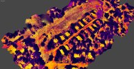
I use Agisoft for my IR maps. It works just fine for me, but I do use the D-RTK-2 unit to keep theM3T drone on a more precise track. I also use NTRIP, when available for the same end, just less equipment. I use it for groundwater as well as structural geology. This was generated with Metashape:
GNT TM.jpg
 
I use Agisoft for my IR maps. It works just fine for me, but I do use the D-RTK-2 unit to keep theM3T drone on a more precise track. I also use NTRIP, when available for the same end, just less equipment. I use it for groundwater as well as structural geology. This was generated with Metashape:
View attachment 176869

Pretty cool.

Did you use a convetor to tiff or just make a visualization map?
 
I just import them directly into Agrisoft Metashape from the folder from the aircraft. Pretty nice program, does pretty much all you need. Just a steep price difference between standard $129 and pro version, $1000. I use just the standard version. I do research, so nobody pays me to do it.
 
Ok. I didn't notice it was a model and not an ortho.

Still pretty cool that it stitched it together so nicely!

I am kinda shocked about the quality since 3D thermal models can be tricky.

Are you using a Mavic 3 Thermal?
 
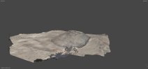
Yes, done with the 3T. I also have a 3E and its models are much more detailed. Do have something to read while it does all the model building. You can also do ortho if you need to with the software. I use 3D for my studies:
Sp1.jpg
 
Thanks for the replies everyone, much appreciated!
I use Agisoft for my IR maps. It works just fine for me, but I do use the D-RTK-2 unit to keep theM3T drone on a more precise track. I also use NTRIP, when available for the same end, just less equipment. I use it for groundwater as well as structural geology.
Do I understand correct that Agisoft is able to import the IR photos from M3T and compile them in to a georeferenced 2D orthomosaic map? Just trying to avoid any additional converting etc. and keep the workflow as simple as possible. Though I really appreciate the jaja6009's comment. Didn't realize you'd need to convert the dji thermal format to something else.
 
My workflow is: plug USB cable into drone, move folder to desktop. Go into Metashape browse for the pics to install, select them all, click import photos. It does the importation, then you start the various steps to make the different models you want to make. It goes through various steps to build your model, texture, point cloud. You can then view as a perspective or orthomosaic. You can download it and try it out for 30 days, it just restricts your outputs. I did that and used the Mac select screenshot area. I fond it very useful and purchased it.
 
Thanks for the replies everyone, much appreciated!

Do I understand correct that Agisoft is able to import the IR photos from M3T and compile them in to a georeferenced 2D orthomosaic map? Just trying to avoid any additional converting etc. and keep the workflow as simple as possible. Though I really appreciate the jaja6009's comment. Didn't realize you'd need to convert the dji thermal format to something else.
Do I understand correct that Agisoft is able to import the IR photos from M3T and compile them in to a georeferenced 2D orthomosaic map?

Yes, but this is just a visualization map. There will be no temperature data.

If you want a radiometric thermal map where you can obtain the temperature value of each pixel in the thermal map, you will need convertor software. With a radiometric map you can click on the ortho and obtain the temperature of where you clicked.
 
Perhaps, I do not use the raidometric mesurements. I use it for structural. It may be able to, you should try the free trial and explore it.
 
Thank you both, I think I have my answers now. Temperature data is quite essential in order to classify and analyse the orthomap in gis software. This was very helpful!
 
Lycus Tech Mavic Air 3 Case

DJI Drone Deals

New Threads

Forum statistics

Threads
133,128
Messages
1,580,364
Members
161,779
Latest member
SilverEagleSix