DJI Mavic, Air and Mini Drones
Friendly, Helpful & Knowledgeable Community
Join Us Now

Mavic 3 flyaway

Where are you finding data on wind speeds and gusts to believe?

Have you read post #40? The behavior of the aircraft can be explained by factors other than wind.
Just based on a knowledge of how the drone reacts to wind and the fact that the drone doesn't show significant gps movement from the tilts. It's all based on observable data and expected reactions to that data. It's also based on an understanding of how wind can change coming over cliffs or going up mountain slopes--very different from ground level. Understanding wind was important in my pilot days. Wind is part of the study for 107 pilot certificate. If you want actual data, set up an AirData account for 400 flights and upload your .txt file. There is a lot to learn from that, It will show you wind speed and direction at various points of your flight. If you can show me data showing there was no wind at altitude then I'll change my reasoning.
 
  • Haha
Reactions: Ex Coelis
I tried a few programs and there is nothing on that file , not a single frame was recorded. Now Im thinking aliens. :rolleyes:

Phantomrain.org
Gear to fly in the Rain. Land on the Water
Kinda what I mean. I'm going to keep on DJI for a replacement and figure out the rest later, I guess. If I messed up, this would be a lessons learned from my obvious (huge) mistake and I'd admit to it in a heartbeat. It was a perfect storm of oh crap.
 
  • Haha
Reactions: Phantomrain.org
As for the corrupt cache file, is there space on the SD card?
Are your DJI Fly app cache settings to delete cache file automatically when the cache reaches a certain level? For the Air 2s that can be changed.
 
No, I'm certain it was recording. Otherwise a file wouldn't have even been created in the cache. That's what I mean, there is a lot of weirdness going on
It is just corrupted because the file wasn't closed properly. I've had the same thing happen with the last file on the microSD card, before a crash that caused the battery to be ejected. Most recovery programs are designed to recover from bad sectors on the microSD card, or files that have been deleted, rather than a file that never got a chance to close properly. This is only exacerbated when the file has to be transmitted to the device from the drone. The drone can sometimes still recover an unclosed file if the power was shut off before stopping recording, by powering back up. However, when the drone and the card are unavailable, and if the recovery programs don't work on the corrupted tablet file, not much more you can do.
 
Just based on a knowledge of how the drone reacts to wind and the fact that the drone doesn't show significant gps movement from the tilts. It's all based on observable data and expected reactions to that data. It's also based on an understanding of how wind can change coming over cliffs or going up mountain slopes--very different from ground level. Understanding wind was important in my pilot days. Wind is part of the study for 107 pilot certificate. If you want actual data, set up an AirData account for 400 flights and upload your .txt file. There is a lot to learn from that, It will show you wind speed and direction at various points of your flight. If you can show me data showing there was no wind at altitude then I'll change my reasoning.

Ok, good. That's settled. We agree that there is no data on wind and wind gusts for the flight being discussed here.
 
As for the corrupt cache file, is there space on the SD card?
Are your DJI Fly app cache settings to delete cache file automatically when the cache reaches a certain level? For the Air 2s that can be changed.
512gb micro SD in the rc pro and drone. Set to auto for overwrite and I backup to my nas immediately and clear it off everytime I get home
 
  • Like
Reactions: GadgetGuy
Just based on a knowledge of how the drone reacts to wind and the fact that the drone doesn't show significant gps movement from the tilts. It's all based on observable data and expected reactions to that data. It's also based on an understanding of how wind can change coming over cliffs or going up mountain slopes--very different from ground level. Understanding wind was important in my pilot days. Wind is part of the study for 107 pilot certificate. If you want actual data, set up an AirData account for 400 flights and upload your .txt file. There is a lot to learn from that, It will show you wind speed and direction at various points of your flight. If you can show me data showing there was no wind at altitude then I'll change my reasoning.
It's on air flight and the txt is post #2, if you have an account you can upload it as well. According to the data, there was a 6mph wind at 345 degrees. It. Was. Not. Wind.
 
  • Like
Reactions: Phantomrain.org
I believe that would be ground level wind forecast for the area, not actually measured ground wind at takeoff. Is that correct? I use a hand-held anemometer to actually measure surface wind before takeoff.
 
Just based on a knowledge of how the drone reacts to wind and the fact that the drone doesn't show significant gps movement from the tilts. It's all based on observable data and expected reactions to that data. It's also based on an understanding of how wind can change coming over cliffs or going up mountain slopes--very different from ground level. Understanding wind was important in my pilot days. Wind is part of the study for 107 pilot certificate. If you want actual data, set up an AirData account for 400 flights and upload your .txt file. There is a lot to learn from that, It will show you wind speed and direction at various points of your flight. If you can show me data showing there was no wind at altitude then I'll change my reasoning.
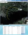
The drone was flying at up to 66mph in a curved path.
Given that the drone would fight to hold position, that would require a wind of approx 100 mph. It's not possible for the OP to have not noticed a hurricane strength wind so close, and it's beyond unlikely that the wind would have followed a curved path as it did.

The compass error caused this crash, and not any wind!
 
Last edited:
Just based on a knowledge of how the drone reacts to wind and the fact that the drone doesn't show significant gps movement from the tilts. It's all based on observable data and expected reactions to that data. It's also based on an understanding of how wind can change coming over cliffs or going up mountain slopes...
You only make one mistake in your assessment... you only look at the data that supports your thesis. The OP clearly say that the drone pointed towards the falls all the time once it came up on height... and that it was drifting backwards when the incident started.

The log tells a very different story... on height the drone pointed north, 90 degrees from what the OP claims. And according to the log the drone drifted sideways, left side first...

All the above together with the curved flyaway path & excessive speeds + attitudes only points in one direction... a yaw error.

Post #40 indicates it was pushed by the wind. So wind did exist.
Wind always exists, even a very mild wind will cause a drift if the flight controller doesn't intervene & keep the position. If the heading information is false the wrong motors will be used to get back to position... The position correction fails leading to another more forceful try which also fails with a positional error that only grows... then the "snowball" get going & the drone flyes away with an increasing speed.

Airdata could make out the wind calculations before the incident started... The wind was clearly not a factor here...

Screenshot_20220719_110136.jpg
 
I launched from a foldout pad on the parking lot/area.
What do you mean by you launched from a "foldout pad".
What is that?
What's it made of?
What other metal was close by (within a couple of feet)?
What was the parking lot surface below your "foldout pad" made of?
If it was concrete, concrete has metal rebar in it that will usually throw a compass error.

The answers will the likely reveal the cause(s) of the compass/yaw error, prior to launch.
 
  • Like
Reactions: Phantomrain.org
Folded pads are generally roughly square pieced of cardboard type material to provide a flat takeoff/landing place. Check pictures on Amazon.
Some people find them more convenient than the "rolled up" circular fabric pads.
 
  • Haha
Reactions: Ex Coelis
Finally, @slup posted some wind data. Thank you.
AirData in this case seems to only have done the wind calculations near home point rather than the entire flight when it really mattered. For my flights AirData shows wind calculations on the wind map for the entire flight so I get a good overview of the wind conditions. Apparently, AirData only sampled data for the takeoff area; winds could be significantly different closer to the cliffs.
Or, does one need to scroll through the log to see the entire wind map?
 
  • Haha
Reactions: Ex Coelis
I went on a family trip to Telluride CO. I drove up to the base of Bridal Veil Falls and took my Mavic 3 off after waiting for about ~30 sec for it to update home point and get 12+ (I think 16) sat connections. Well, I started video and started to ascend from the auto hover altitude and took video going up the fall. I got to the top of the falls (I was back about 400 feet from them) and the drone started backing up with no input from me. After a momentary freakout, I tried to adjust altitude (btw, only 6mph winds, almost nothing to feel) and it started to drift in a half-moon shape circle before crashing and getting lost. During this, I was getting disconnection on video and random drops. I got video back just long enough to see it dive into the trees.
After about an hour of searching and there being no signal to connect to in order to use the "find my drone" I gave up. This was about 300 miles from home and a day trip (long drive back).
It's gone, and I can't figure out what happened. I thought maybe a signal jammer or something, but I'd assume it'd just hover or land if that was the case.

I am very sorry to hear about your drone. I was reading your story. and I had a similiar. issue with my drone Mavic 3 Cine a few weeks back. I did not post my incident to any of the forums, becasue i throught it was me, becasue my drone is fairly new, meaning I purchase it in December 2021 "holidays". I use this drone for work along with my Mavic 2 Pro, still waiting on DJI to finish fixing all of the issues with the Mavic 3 drones.

again..sorry for the lost of your drone. I did not lose mines...thank God!

DjI just help me resolved my issue with this drone. let me try to explain:
the first that i experience and issue with this drone "Mavic 3 Cine", I was doing a job over a huge construction site over a 100+ arces. an small airport on one side of the construction site. the drone would discconnect from the controller several times and kept returning to home point. I did not know if this was due to the vehicles or what? just weird to me. wide open area. Mine me, i have done several jobs like this over the past few years with my other drones.

I did keep track of what equipment that I had attached to the drone. i.e. battery - mark it.

The second time that I experience and issue with this Mavic Cine 3, I was doing another job at different type of site. complex inspections "homes", roughly...76 arces.

disconnecting like crazy...

I have six batteries for this drone.

two of the batteries...fully charge...would disconnect from the drone 30 seconds into the flight, every time. Also sometimes the drone, when the drone disconnect, it would return to home, and sometimes it disconnect, reconnect in place, it would re-establish it home point where it was at, and would just hover, very scary, I would fly it back to me, and land it, and retake off, establish home point, next to me, and try to continue my job.

I notice that this only happen with two of my six batteries.

I created a ticket at DJI, and they confirm it. and sent me two band new batteries.
 
If the heading information is false the wrong motors will be used to get back to position... The position correction fails leading to another more forceful try which also fails with a positional error that only grows... then the "snowball" get going & the drone flyes away with an increasing speed.
Enlightening and well described...
 
Lycus Tech Mavic Air 3 Case

DJI Drone Deals

New Threads

Forum statistics

Threads
134,442
Messages
1,594,815
Members
162,978
Latest member
dojin23