Hi, I recently observed that my Mavic Air 1 is sometimes unable to maintain low flight altitude [3 ~4 m (10 ~ 13 ft) above the ground] even under low to no wind condition. I use this height for active track. Sometimes the drone would be unable to cope and would descend to the ground and then ascend again. Not an issue if I am flying higher [>10 m (30 ft)]. Has anybody experienced this and any suggestions for managing this issue?
You are using an out of date browser. It may not display this or other websites correctly.
You should upgrade or use an alternative browser.
You should upgrade or use an alternative browser.
Mavic Air 1 - Low Altitude hold issue
- Thread starter Atomwild
- Start date
It's much better that you share a flight log from a flight where this happens, easier to see what's going on.
And just so you know ... the MA1's active track doesn't follow uphill, instead it will crash into the ground, it just follows downhill.
Read up here (see point 3.) on how to retrieve the mobile device .txt log from your phone --> Mavic Flight Log Retrieval and Analysis Guide then come back & attach it in a new post here.
wardtom084
Well-Known Member
I am flying over a flat grass field of the park. I typically do some high flights and low ones. I took a look at my flight data and there are too many on that day of flights. I will redo this low flying test in a day or two and extract the correct flight data and post.It's much better that you share a flight log from a flight where this happens, easier to see what's going on.
And just so you know ... the MA1's active track doesn't follow uphill, instead it will crash into the ground, it just follows downhill.
Read up here (see point 3.) on how to retrieve the mobile device .txt log from your phone --> Mavic Flight Log Retrieval and Analysis Guide then come back & attach it in a new post here.
Will redo this low altitude flying again and then post the flight data.Use AirData on all flights and post the log.
I did not have this problem before, it surfaced about a month or two ago. Initially, I thought it might be caused by wind but noticed in my last flight that it also happens without wind. Will do some more tests and pick all of your brains for help.@Atomwild I have not experienced that so far, what kind of surface is under your drone ? Could the obstacle sensors be getting flakey or obscured ?
I regularly fly 10 to 15 ft off the ground with no issues.
Not likely...I had one other thought, could you have a battery that is going or a bad motor ?
A bad battery, so bad that the voltage rapidly falls will cause a auto landing, not a slow descent.
And if a motor doesn't perform the craft will start to rotate as all 4 motors aren't in balance thrust torque wise anymore.
I had one other thought, could you have a battery that is going or a bad motor ?
Surprisingly, you hit the nail on the head. I did low-altitude flight (<10 ft) runs and hovering on all my 3 batteries and it was one of the batteries that caused this problem (although all 3 batteries are in good conditions and at higher altitude (> 30 ft), the drone performed beautifully with all of them).I had one other thought, could you have a battery that is going or a bad motor ?
I believe low altitude flying will require higher battery power vs higher altitude and that one battery was unable to sustain the higher loading, resulting in the drone descending to the ground and ascending after that. For the other 2 batteries, I tested it for at least 10 mins flight and hovering (including maintaining it at the 3 ft take-off altitude), the drone maintained the low altitude level stably and correctly.
Problem solved. Thanks everyone for your helpful input, suggestions, and tips.
That's not at all how a battery or the DJI software works ... you haven't solved the problem unfortunately....I believe low altitude flying will require higher battery power vs higher altitude and that one battery was unable to sustain the higher loading, resulting in the drone descending to the ground and ascending after that...
Problem solved.
If a battery ... even though it's worn and prone to voltage drops during higher amp draw... doesn't hit the 3v/cell limit (where the AC will start to force land) it will sustain a hover or a active track flight. If a forced landing is initiated that will be clearly spelled out in the GO 4 app ... & the AC will absolutely not recover from that, it will land what ever you want.
It's something entirely different that causes this ... and the best clues comes from the mobile device flight logs.
So instead of relying on speculation, upload your log & then let's see what it reveals ...
@Atomwild you had a disconnect between the IMU altitude and VPS altitude at about 7 min in. Imu was reporting negative alt the VPS positive.
I do not understand the interaction between the 2 very well but at the very least I would recalibrate the IMU as a simple step.
Additionally the battery voltage jump and dropped in that range not by much but by a little, which I find odd.
I do not understand the interaction between the 2 very well but at the very least I would recalibrate the IMU as a simple step.
Additionally the battery voltage jump and dropped in that range not by much but by a little, which I find odd.
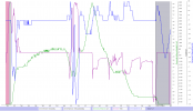
In the second half of the flight you constantly commanded negative throttle (purple graph) for descent most of the flight & the vertical speed (blue graph positive for descend & negative for ascend) answered nicely with positive values. The green graph shows the height above ground directly beneath the AC measured by the VPS sensors on the belly ... in the end of the flight just where the grey background starts (which indicate a force landing) you are just 0,5m above ground ... and continue to apply negative throttle for descending, which at that height (0,5m) initiate a "vertical low limit force landing"....Here is the correct attachment of the flight that had the low altitude issue.
So ... you can't fly lower over the ground beneath the AC than 0,5m, applying throttle for descend there will start the landing process.
(Click on the charts below to make them larger)

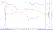
It's one spot that stands out though ... it's between 414sec to 420sec approx. where the barometric height (red graph) decreases from 5,2m to 1,3m without any throttle input ... at the time the AC was 3,2m above ground beneath. This could indicate that the barometric sensor isn't fully functional. If you could share the corresponding mobile device DAT log for this flight ... maybe something in there can give a clue. The correct DAT log ends with FLY058.DAT ... it's located in a sub folder MCDatFlightRecords in the same place where you founds the .TXT log you attached.

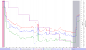
And just to show off the battery data ... to end the speculation, no problem with that battery.

... you had a disconnect between the IMU altitude and VPS altitude... Imu was reporting negative alt the VPS positive.
I do not understand the interaction between the 2 very well but at the very least I would recalibrate the IMU as a simple step.
It's perfectly normal that the barometric height (which always is relative to the take off point where the sensor is reset just after take off) ... can differ from the VPS height which measures the height above ground directly beneath the AC.
If you take off from the top of a 50m high hill and fly down in the valley & stopped 1m above ground down there the barometric height will report -49m ... but the VPS heigh would be +1m.
No need to calibrate any IMU's ...
Last edited:
@slup just to ask a what maybe a dumb question:
If he took off at a level point the two altitudes should generally be the same correct ?
In the image below you can see a very sudden change in the IMU VS VPS altitude. Based on your information he would have had to flown over a fair significant dip in the ground, if I am understanding this correctly.
Looking at the 2 pieces of altitude data, from the 1st log this appears to be what happened.
Would that be a correct interpretation of the data ?

Can't see anything in that pic ... but in general, flying enough close over flat ground both the VPS & the barometric height should follow pretty well ... the barometric height can drift a bit through out a flight though. If the barometric height remains constant but the VPS height increases means that the height relative the take off point is constant but the ground beneath the AC falls off.@slup just to ask a what maybe a dumb question:
If he took off at a level point the two altitudes should generally be the same correct ?
In the image below you can see a very sudden change in the IMU VS VPS altitude. Based on your information he would have had to flown over a fair significant dip in the ground, if I am understanding this correctly.
Looking at the 2 pieces of altitude data, from the 1st log this appears to be what happened.
Would that be a correct interpretation of the data ?
View attachment 132906
Hi guys, thanks for the input. Just to add context to the area I did on low altitude flying, it's a big flat area of grass akin to a football field. I was flying in the morning where the sun is at an angle.
I read that flying drone close to water could cause VPS to be confused due to the reflection and transparency of the water, so the recommendation is to fly above 30 feet if it's above water. Maybe the morning sun reflecting on an almost uniform grass area could cause VPS confusion leading to this low altitude issue.
On my 2nd and 3rd successful low altitude flights with the other batteries, I did not test the drone on the same spot as the 1st battery. As the ground is flat and it's a big area, I just flew at other locations within the same field.
I will do another test next week at the same spot that has this issue with all different batteries and with VPS turn on and off and see what results I get.
Here are the 2 DAT files you requested.In the second half of the flight you constantly commanded negative throttle (purple graph) for descent most of the flight & the vertical speed (blue graph positive for descend & negative for ascend) answered nicely with positive values. The green graph shows the height above ground directly beneath the AC measured by the VPS sensors on the belly ... in the end of the flight just where the grey background starts (which indicate a force landing) you are just 0,5m above ground ... and continue to apply negative throttle for descending, which at that height (0,5m) initiate a "vertical low limit force landing".
So ... you can't fly lower over the ground beneath the AC than 0,5m, applying throttle for descend there will start the landing process.
(Click on the charts below to make them larger)
View attachment 132904
It's one spot that stands out though ... it's between 414sec to 420sec approx. where the barometric height (red graph) decreases from 5,2m to 1,3m without any throttle input ... at the time the AC was 3,2m above ground beneath. This could indicate that the barometric sensor isn't fully functional. If you could share the corresponding mobile device DAT log for this flight ... maybe something in there can give a clue. The correct DAT log ends with FLY058.DAT ... it's located in a sub folder MCDatFlightRecords in the same place where you founds the .TXT log you attached.
View attachment 132908
And just to show off the battery data ... to end the speculation, no problem with that battery.
View attachment 132905
It's perfectly normal that the barometric height (which always is relative to the take off point where the sensor is reset just after take off) ... can differ from the VPS height which measures the height above ground directly beneath the AC.
If you take off from the top of a 50m high hill and fly down in the valley & stopped 1m above ground down there the barometric height will report -49m ... but the VPS heigh would be +1m.
No need to calibrate any IMU's ...
Attachments
Similar threads
- Replies
- 3
- Views
- 3K
- Replies
- 16
- Views
- 692
- Replies
- 9
- Views
- 2K
- Replies
- 7
- Views
- 2K
- Replies
- 6
- Views
- 2K
DJI Drone Deals
New Threads
-
-
-
RC 2 Controller Firmware: v08.00.0000 Mini 4 or v08.01.0100 Mini 5
- Started by Calson
- Replies: 0
-
-


