


You are using an out of date browser. It may not display this or other websites correctly.
You should upgrade or use an alternative browser.
You should upgrade or use an alternative browser.
Mavic Mini does full 360° panorama!
- Thread starter NEWorldPhoto
- Start date
RogerDH
Well-Known Member
It's very possible that the Mini can't support 4K video because of hardware limitations, but I do believe that every one of the other features that you mentioned -- RAW, HDR, AEB, Burst, and automatic panorama modes -- and more (e.g. ActiveTrack and waypoints) are all well within its capabilities. But DJI seems to be content to sell the nearly brain-dead Mini on the strength of its DJI badge, even though it has far less functionality than its competition....
Unfortunately, it seems there are some hardware limitations that prevent having those advanced features, as they apparently require more powerful processors that run hotter and require a cooling fan like the other Mavics have, and that will add to the weight and make it impossible to keep the drone's weight under 250g...
It's very possible that the Mini can't support 4K video because of hardware limitations, but I do believe that every one of the other features that you mentioned -- RAW, HDR, AEB, Burst, and automatic panorama modes -- and more (e.g. ActiveTrack and waypoints) are all well within its capabilities. But DJI seems to be content to sell the nearly brain-dead Mini on the strength of its DJI badge, even though it has far less functionality than its competition.
I remember reading somewhere that DJI said they couldn't enable 4K on the Mini because there was no space for a cooling fan or something like that. I doubt if that's true or not, because as another member said before in this thread, the DJI Osmo action camera can record 4K without needing a cooling system, as well as so many miniature action cameras and also all our smartphones can capture 4K video and they don't need cooling fans or heatsinks. Unless, maybe the flight controller processor alone has to work so hard just to control everything that keeps the flight stable, and that requires a lot of processing and generates heat, so capturing 4K may need even more powerful processing and will get hotter, needing a fan or bigger heatsink, which will increase the drone's weight above 250g. That could be the possible technical limitation for capturing 4K and keeping the weight less than 250g at the same time. An action camera or smartphone doesn't have a flight controller processor that consumes power and generates heat, so they can process 4K capture without needing additional processing power for flight control, and therefore won't heat to the point of needing a heavier cooling system.
In fact the Mini gets quite hot just for simply doing a flight. And currently there's absolutely NO OTHER sub-250g drone on the market that can record true 4K video AND weigh less than 250g at the same time. It simply doesn't exist at this time. Yes, there's a lot of cheap drones out there that claim to record 4K and also weigh less than 250g at the same time, but in reality all those knockoffs actually DO NOT capture true 4K video, the "4K" spec they advertise means that the sensor merely captures 4K resolution STILL PICTURES, which are just 8 megapixels stills; but for video, they are actually barely able to capture video at a bit higher resolution than 1080 at most, but NOT even reach the actual 2.7k resolution that the Mini does.
So apparently there's currently some technical limitation in making a sub-250g drone that also records true 4K video, because nobody has been able to produce one. If somebody sees a drone that weighs less than 250g and also captures true 4K video AT LEAST AT 24 fps, and is able to physically verify that capability is real, please let us know!
So far, the lightest drone that I know of that can do 4K video is the Parrot Anafi, which weighs 320g, more than 250. And it has a cooling fan.
But I DO believe that the Mini SHOULD be capable of doing automated HDR, AEB, burst, panorama, etc. In fact Litchi already added automated panorama to the Mini, and it works, as mentioned before in this thread. Also DroneLink software can be programmed with scripts that can make commands to the Mini to do automated bracketing, bursts, etc. And the lack of processing power should not be a problem either to save the RAW image, even if it takes a while to perform the operation. I also did HDR by manually bracketing exposures with the Mini and posted some samples in this thread before.
I know that older Canon point-and-shoot digital cameras that didn't have RAW, there's a hacked firmware that can be run on them on top of the stock firmware, and makes possible to save the camera image capture data in DNG! I had one of such cameras and was able to capture perfectly usable DNG images with it.
So I hope somebody does the same with the Mini and enables it to save the RAW image data. And yes, RAW images DO make a noticeable difference in image quality captured with these small sensors. Both the Mavic Pro and the Parrot Anafi get better image quality by shooting in DNG.
RogerDH
Well-Known Member
This morning, I finally got around to testing the 360 Photo component in Dronelink's public repository, stitching the 25 photos it produced using Microsoft's freeware Image Composite Editor. It worked very well! It could be modified to do HDR, but there's probably already an HDR version somewhere.
I also learned from YouTube how to make these compatible with Facebook's 360 viewer: It's recommended to resize them to 6000x3000, then just use an EXIF metadata editor to say that the camera manufacturer is "Ricoh" and the model is "Ricoh Theta S." (This will actually work with any photo, but it will just look rather strange if it's not really a 360 panorama.) There are several online EXIF editors that will let you upload, modify, and download the edited file.
I also tested ICE's ability to make a full 360 panorama directly from a video, and it did work surprisingly well, given all the camera gyrations. This was a component with a list of commands to start the video, rotate 360, drop the gimbal and rotate again, then do it again all the way down to -90 degrees. It's lower resolution than the photo version, of course, and it took quite a bit longer than from photos, so I think I prefer using the Dronelink component photos for 360s. However, I frequently use ICE to make smaller panoramas directly from video because it's so convenient: Anytime you have a section of video that's panning around -- up and down or back and forth, or both -- ICE can make a panorama from it.

With Litchi (iOS version), this whole process is as easy as basically 3 clicks! 1 click to shoot the sphere, 1click to stitch inside of Litchi, 1 click to share to FB. As long as you have iPhone 7+ or better, the pano resolution will be approx 100MP (14000*7000) which is the max that Facebook will accept.This morning, I finally got around to testing the 360 Photo component in Dronelink's public repository, stitching the 25 photos it produced using Microsoft's freeware Image Composite Editor. It worked very well! It could be modified to do HDR, but there's probably already an HDR version somewhere.
I also learned from YouTube how to make these compatible with Facebook's 360 viewer: It's recommended to resize them to 6000x3000, then just use an EXIF metadata editor to say that the camera manufacturer is "Ricoh" and the model is "Ricoh Theta S." (This will actually work with any photo, but it will just look rather strange if it's not really a 360 panorama.) There are several online EXIF editors that will let you upload, modify, and download the edited file.
I also tested ICE's ability to make a full 360 panorama directly from a video, and it did work surprisingly well, given all the camera gyrations. This was a component with a list of commands to start the video, rotate 360, drop the gimbal and rotate again, then do it again all the way down to -90 degrees. It's lower resolution than the photo version, of course, and it took quite a bit longer than from photos, so I think I prefer using the Dronelink component photos for 360s. However, I frequently use ICE to make smaller panoramas directly from video because it's so convenient: Anytime you have a section of video that's panning around -- up and down or back and forth, or both -- ICE can make a panorama from it.
Last edited:
RogerDH
Well-Known Member
Yes, I know -- I looked into Litchi quite a bit while we were waiting for the SDK -- but my post was for the benefit of those who already bought Dronelink or are thinking about it: We can do panoramas, too.With Litchi (iOS version), this whole process is as easy as basically 3 clicks! 1 click to shoot the sphere, 1click to stitch inside of Litchi, 1 click to share to FB. As long as you have iPhone 7+ or better, the pano resolution will be approx 100MP (14000*7000) the max that Facebook can accept.
") The thing I like about Dronelink is that I can now modify a copy of that component to do, say, a panorama of two rows of three images, which is the kind of "simulated wide-angle" panorama that I'm more likely to use than a 360.
The thing I like about Dronelink is that I can now modify a copy of that component to do, say, a panorama of two rows of three images, which is the kind of "simulated wide-angle" panorama that I'm more likely to use than a 360.I mentionned the standard 360 photo sphere as it is the easiest one to do since there is a preset for it but other types of panos are also supported and all settings can be adjusted to your liking and stitched/shared without leaving the app.Yes, I know -- I looked into Litchi quite a bit while we were waiting for the SDK -- but my post was for the benefit of those who already bought Dronelink or are thinking about it: We can do panoramas, too.
ff22
Well-Known Member
Thanks for that info. I just tried ICE a bit ago on a video. Nice. It was a video 360 pan I took on a hike with the DJI Osmo Action. I only grabbed a portion of the pan.This morning, I finally got around to testing the 360 Photo component in Dronelink's public repository, stitching the 25 photos it produced using Microsoft's freeware Image Composite Editor. It worked very well! It could be modified to do HDR, but there's probably already an HDR version somewhere.
I also learned from YouTube how to make these compatible with Facebook's 360 viewer: It's recommended to resize them to 6000x3000, then just use an EXIF metadata editor to say that the camera manufacturer is "Ricoh" and the model is "Ricoh Theta S." (This will actually work with any photo, but it will just look rather strange if it's not really a 360 panorama.) There are several online EXIF editors that will let you upload, modify, and download the edited file.
I also tested ICE's ability to make a full 360 panorama directly from a video, and it did work surprisingly well, given all the camera gyrations. This was a component with a list of commands to start the video, rotate 360, drop the gimbal and rotate again, then do it again all the way down to -90 degrees. It's lower resolution than the photo version, of course, and it took quite a bit longer than from photos, so I think I prefer using the Dronelink component photos for 360s. However, I frequently use ICE to make smaller panoramas directly from video because it's so convenient: Anytime you have a section of video that's panning around -- up and down or back and forth, or both -- ICE can make a panorama from it.
Seisiuneer
Member
Here's my most recent Mavic Mini panorama of the El Cajon Valley east of San Diego using the interval shooting and stitching in Autopano, EXIF injection using ExifFixer.
Click the image to enter the viewer, then the panorama icon in the center of the image to view full screen and pan/zoom the image.
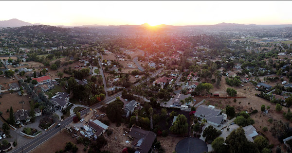
Click the image to enter the viewer, then the panorama icon in the center of the image to view full screen and pan/zoom the image.
monteolsen1
Well-Known Member
Very nice !!. How many photos, altitude, how much time of shooting? Beautiful job.(Update: HERE'S THE LINK TO THE MINI'S 360 PANORAMA, SO YOU CAN FIND IT EASIER).
I have to admit, when the MM was released, I was disappointed that it lacked several advanced features found on higher end Mavics, like RAW, HDR, AEB, Burst, 4K, and automatic panorama modes. A shame, since the Mini is so capable in everything else, has excellent image quality, stable, and very lightweight and portable. If it had those more advanced features, surely it will be a real hit and home run!
Unfortunately, it seems there are some hardware limitations that prevent having those advanced features, as they apparently require more powerful processors that run hotter and require a cooling fan like the other Mavics have, and that will add to the weight and make it impossible to keep the drone's weight under 250g. And even if it's technically possible, maybe DJI doesn't want the Mini to cannibalize sales of higher models like the Air 2, etc.
However.. experts and enthusiasts always find workarounds with limitations, and the MM's capabilities are no exception. Recently Litchi released a Beta app that allows the MM to do a full panorama automatically, like the other Mavics; in this YouTube video somebody tested the Litchi Beta in the MM and did an auto panorama successfully.
BUT.. it's actually possible to do a full 360 panorama manually with the MM, without additional software! Just set the exposure a bit darker (like -1EV), so bright parts of the scene are not overexposed and therefore rendering highlight details unrecoverable. (Unlike overexposure, underexposed -darker- details can be brightened and recovered better). Then, lock the exposure with AE lock, or use manual exposure mode to maintain the same exposure through all the panorama. Now take overlapping shots all around and up & down to the bottom so it covers the entire surroundings like a sphere.
I tested doing a full 360 spherical panorama manually with the MM, and here are the results!
It worked very well, stitched perfectly with very few stitching artifacts that were fixable in editing software, and despite the fact that there was even a good amount of wind, the Mini kept stable enough to not cause stitching problems!
Next up?... how to do an HDR image manually!
Oh well.. something weird happened and the link I posted with the Mini’s panorama is now showing the incorrect view! Kuula seems to have messed up something, and now when I touch the link, what shows up is another, different panorama I did with a Mavic Pro, not the Mini. Maybe that’s the one you saw, which of course is more impressive than the one I did with the Mini. ?Very nice !!. How many photos, altitude, how much time of shooting? Beautiful job.
HERE IS THE LINK TO THE CORRECT PANORAMA DONE WITH THE MAVIC MINI.

Last edited:
Jaaaa, the other one Is impressive AND this one así well, same questions apply bacause I love to try ir myself. Saludos.Oh well.. something weird happened and the link I posted with the Mini’s panorama is now showing the incorrect view! Kuula seems to have messed up something, and now when I touch the link, what shows up is another, different panorama I did with a Mavic Pro, not the Mini. Maybe that’s the one you saw, which of course is more impressive than the one I did with the Mini. ?
HERE IS THE LINK TO THE CORRECT PANORAMA DONE WITH THE MAVIC MINI.
I took more than 90 photos all around and all the way from above to the ground below, to make sure to capture the entire spherical view. The more overlap between each shot the better, and more shots ensure that the stitching software has more detail to work with, and less chance of stitching errors. It was hovering at around 120m altitude, and the entire process took me about 7 minutes to shoot; the Mini needs about 2 seconds to process and save each shot.Jaaaa, the other one Is impressive AND this one así well, same questions apply bacause I love to try ir myself. Saludos.
First I centered the horizon at half the frame and snapped a series of shots all around, then tilted the camera gimbal down so the horizon was at the very top of the frame, and did the same shots 360° around, keeping the same tilt angle. And then another row of shots 360 around at a lower angle down, making sure the tilted down angle frames' top part overlaps a good amount with the bottom part of the previous row of shots. I continued to take rows of stills 360° around at the same angle, every time lowering the camera more between rows, until the camera pointed 90° downwards, and took a few shots with the camera facing all the way down, rotating the drone in all directions.
Finally I tilted the camera all the way up so the horizon is at the bottom of the frame, to capture as much sky as possible, and did the same thing of shooting a series of overlapping images 360° around.
However, there was considerable wind, and that causes the gimbal to not be able to rotate all the way completely up or down at the headings or direction the wind is blowing, because the drone body itself has to pitch/tilt up, down, right or left against the wind direction in order to "fight" or compensate the force of the wind flow to keep hovering at the same place. For example, when the drone is facing the wind, it has to pitch down at an angle, but the camera gimbal remains straight forward, so it actually has to pivot up to compensate for the drone's downward inclination and remain level. Then if you tilt the camera all the way up while the drone is pitched a bit down to face the wind, the gimbal will reach the top of the drone body and stop rotating up, causing the frame to not reach the maximum upward angle.
Fortunately this limitation didn't affect the ability to achieve a complete 360x180 panorama, the gimbal was able to move up and down enough to not miss any details.
At the end, all those images are stitched together and processed into an equirectangular 2:1 ratio 360x180° spherical panoramic image. There's a program called "SkyFill" that automatically fills the sky to complete the spherical 360x180 final image.
Here's another panorama I did with the Mini the same way:

Buena suerte con el panorama del Mini!
BokiFly
Well-Known Member
Extensive and detailed explanation, I appreciate it very much and when I have my first panorama ready I will share it, greetings.I took more than 90 photos all around and all the way from above to the ground below, to make sure to capture the entire spherical view. The more overlap between each shot the better, and more shots ensure that the stitching software has more detail to work with, and less chance of stitching errors. It was hovering at around 120m altitude, and the entire process took me about 7 minutes to shoot; the Mini needs about 2 seconds to process and save each shot.
First I centered the horizon at half the frame and snapped a series of shots all around, then tilted the camera gimbal down so the horizon was at the very top of the frame, and did the same shots 360° around, keeping the same tilt angle. And then another row of shots 360 around at a lower angle down, making sure the tilted down angle frames' top part overlaps a good amount with the bottom part of the previous row of shots. I continued to take rows of stills 360° around at the same angle, every time lowering the camera more between rows, until the camera pointed 90° downwards, and took a few shots with the camera facing all the way down, rotating the drone in all directions.
Finally I tilted the camera all the way up so the horizon is at the bottom of the frame, to capture as much sky as possible, and did the same thing of shooting a series of overlapping images 360° around.
However, there was considerable wind, and that causes the gimbal to not be able to rotate all the way completely up or down at the headings or direction the wind is blowing, because the drone body itself has to pitch/tilt up, down, right or left against the wind direction in order to "fight" or compensate the force of the wind flow to keep hovering at the same place. For example, when the drone is facing the wind, it has to pitch down at an angle, but the camera gimbal remains straight forward, so it actually has to pivot up to compensate for the drone's downward inclination and remain level. Then if you tilt the camera all the way up while the drone is pitched a bit down to face the wind, the gimbal will reach the top of the drone body and stop rotating up, causing the frame to not reach the maximum upward angle.
Fortunately this limitation didn't affect the ability to achieve a complete 360x180 panorama, the gimbal was able to move up and down enough to not miss any details.
At the end, all those images are stitched together and processed into an equirectangular 2:1 ratio 360x180° spherical panoramic image. There's a program called "SkyFill" that automatically fills the sky to complete the spherical 360x180 final image.
Here's another panorama I did with the Mini the same way:
Buena suerte con el panorama del Mini!
I took more than 90 photos all around and all the way from above to the ground below, to make sure to capture the entire spherical view. The more overlap between each shot the better, and more shots ensure that the stitching software has more detail to work with, and less chance of stitching errors. It was hovering at around 120m altitude, and the entire process took me about 7 minutes to shoot; the Mini needs about 2 seconds to process and save each shot.
First I centered the horizon at half the frame and snapped a series of shots all around, then tilted the camera gimbal down so the horizon was at the very top of the frame, and did the same shots 360° around, keeping the same tilt angle. And then another row of shots 360 around at a lower angle down, making sure the tilted down angle frames' top part overlaps a good amount with the bottom part of the previous row of shots. I continued to take rows of stills 360° around at the same angle, every time lowering the camera more between rows, until the camera pointed 90° downwards, and took a few shots with the camera facing all the way down, rotating the drone in all directions.
Finally I tilted the camera all the way up so the horizon is at the bottom of the frame, to capture as much sky as possible, and did the same thing of shooting a series of overlapping images 360° around.
However, there was considerable wind, and that causes the gimbal to not be able to rotate all the way completely up or down at the headings or direction the wind is blowing, because the drone body itself has to pitch/tilt up, down, right or left against the wind direction in order to "fight" or compensate the force of the wind flow to keep hovering at the same place. For example, when the drone is facing the wind, it has to pitch down at an angle, but the camera gimbal remains straight forward, so it actually has to pivot up to compensate for the drone's downward inclination and remain level. Then if you tilt the camera all the way up while the drone is pitched a bit down to face the wind, the gimbal will reach the top of the drone body and stop rotating up, causing the frame to not reach the maximum upward angle.
Fortunately this limitation didn't affect the ability to achieve a complete 360x180 panorama, the gimbal was able to move up and down enough to not miss any details.
At the end, all those images are stitched together and processed into an equirectangular 2:1 ratio 360x180° spherical panoramic image. There's a program called "SkyFill" that automatically fills the sky to complete the spherical 360x180 final image.
Here's another panorama I did with the Mini the same way:
Buena suerte con el panorama del Mini!
hi,
has anyone tried the litchi official release on android to do spherical 360...
what pano settings are good to get as much coverage as possible for 360x180, ie values for columns, height, row, nadir
(i've enabled the gimbal to go up +20°)
am planning to fill in the zenith sky and use ptgui to stitch the photos
from litchi user guide on panorama mode
- Columns: The width is divided in columns which define the aircraft/gimbal yaw angles where photos are taken.
- Height: The height of the panorama in degrees. The height will be centered on the gimbal's pitch when starting the panorama. If the 'Nadirs' setting is set to 1 or more, the height of the panorama will be clamped to the bottom of the panorama. For example: with 'Height' set to 40° and 'Nadirs' set to 0, the panorama will be shot from -20° to +20° (assuming the gimbal is at 0° at the beginning of the panorama); with 'Height' set to 90° and 'Nadirs' set to 1, the panorama will be shot from -90° to +0°.
- Rows: The height is divided in rows which define the gimbal pitch angles where photos are taken.
- Nadirs: The number of Nadirs (bottom shots) that will be taken. If the 'Width' is set to less than 360° or if 'Columns' is set to 1, no 'Nadirs' shots will be taken.
thanks
Bussty
Well-Known Member
I have been using the Mavic Mini 1 and Litchi for quite a while now. Just select the 360 Pano button and let it do its' thing. Always manual exposure, light balance and I sometimes use the AEB bracket. I usually find the brightest part of the scene then manually bring the exposure down using the highlight warning option so that brightest bit is just exposed. Then I open up a stop and run +1 AEB on the automatic 360 Litchi option. I batch process the HDR's in SNS-HDR Pro (what an awesome program) then stitch together using PTGUI (another awesome piece of software.) Using Android Phone S9+
I finish off in Affinity Photo to clone the sky "hole"...
Examples here... 360 Panoramas of New Zealand Landscapes by Andrew Busst
For what it is the Mini is amazing for this.
Good luck!
I finish off in Affinity Photo to clone the sky "hole"...
Examples here... 360 Panoramas of New Zealand Landscapes by Andrew Busst
For what it is the Mini is amazing for this.
Good luck!
thanks for the workflow...will check out the resources and tools (i use photomatix for hdr)I have been using the Mavic Mini 1 and Litchi for quite a while now. Just select the 360 Pano button and let it do its' thing. Always manual exposure, light balance and I sometimes use the AEB bracket. I usually find the brightest part of the scene then manually bring the exposure down using the highlight warning option so that brightest bit is just exposed. Then I open up a stop and run +1 AEB on the automatic 360 Litchi option. I batch process the HDR's in SNS-HDR Pro (what an awesome program) then stitch together using PTGUI (another awesome piece of software.) Using Android Phone S9+
I finish off in Affinity Photo to clone the sky "hole"...
Examples here... 360 Panoramas of New Zealand Landscapes by Andrew Busst
For what it is the Mini is amazing for this.
Good luck!
Similar threads
- Replies
- 7
- Views
- 704
- Replies
- 16
- Views
- 1K
- Replies
- 5
- Views
- 2K
- Replies
- 0
- Views
- 964


DJI Drone Deals
New Threads
-
-
Lost drone: possible crash due to lost signal?
- Started by fharrihill
- Replies: 3
-

-
 Last Week's Most Popular Topics (January 31, 2026)
- Started by msinger
- Replies: 0
-
 How to Protect and Extend the Life of your Equipment in 2026 (By Timothy Brazzel)
- Started by The Droning Company
- Replies: 2
Forum statistics
