Yesterday I took my Mavic Pro on a routine flight, with a fully charged battery and a normal default RTH height of 98 ft, flying in normal mode (not sport) for the entire flight. It was 0 degrees C at the time...I fear this could be the root of all the problems I then experienced.
4 minutes into the flight, with 81% battery and at a height of 250 ft, I hit return to home.
Something very strange then happened.
The sequence of events that followed immediatley after were:
1. In RTH mode, Mavic started to climb, without any input from me.
2. I tried to counter this by pulling down on the altitude stick briefly, log shows me pulling down on stick 20%-60% for around 2 seconds. This cancelled the RTH.
3. The Mavic didn't respond and rapidly continued to climb and was also now flying away from me, backwards, with no input from me on the remote control.
4. The Mavic climbed to 311 ft on its own, and I again hit RTH, and it went into RTH mode.
5. The Mavic continued to climb with no input from me, and continued to rapidly fly further away in a straght line ascending upwards, and making big distance gains away from me.
6. I again tried to counter this by pushing the forward stick 100% on the RC, for 15 seconds. This did nothing, and the Mavic continued to fly away backwards in a straght line at around 12mph and rapidly climbing without any command, was now up to 370 ft and climbing.
7. I again hit RTH, and it went back into RTH mode.
8. In RTH mode and with no input from me on the RC, it continued to rapidly climb through 400 ft, and continuing to fly away from me backwards, totally out of control and getting further and further away.
9. Climbing through 403 ft, speeding away from me, "Battery:Overcurrent during discharge" warning was displayed. Never experienced this before.
10. Still with no input from me on the RC whatsoever, Mavic continued to fly away in a straght line, climbing, now at 420 ft and distance by this point becoming a real concern (had now reached 7,700 ft away from me, still out of control)
11. This continued a few more seconds and at a height now of 430 ft, I recieved "Motor Current Error" warning, also never experienced before. Battery at this exact moment showed 54% remaining and 4 min 30 sec remaining on the countdown bar.
12. At a height of 440 ft and climbing, and a somewhat terrifying 7900 ft away, it disconnected, and never reconnected.
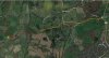
This all happened over a golf course. It was unoccupied at the time, due to being covered in snow. I immediatley got in the car and drove to the area, and pulled up Find My Drone on my iPhone. On foot, I went to the exact point shown on the map, which was in the middle of a green area. No sign of the mavic anywhere.
I then spent the next 2 hours searching the area, without being able to find it. Today, I went back with two others and we searched the area extensivley again for a further 3 hours, and nothing. We tried to simulate the drone flying further away in a straght line, searching the area but no sign of it. I guess this suggests the flight continued for some time on its own accord following disconnect and went further away. There are woods either side of the area, so likely it could be in there somewhere and that is literally like trying to find a needle in a haystack.
I will try and upload the flight logs, but upon first glance has anybody ever experienced this complete loss of control and does anybody have any idea as to why this may have happened?
I will contact DJI care about this, and will update this thread with their response when I get it. I'm looking at a claim on my home insurance for this, but in the meantime would love to hear if anyone has experienced similar issues as this was pretty scary, and has sadly resulted in a complete loss.
Thanks all in advance
Justin
4 minutes into the flight, with 81% battery and at a height of 250 ft, I hit return to home.
Something very strange then happened.
The sequence of events that followed immediatley after were:
1. In RTH mode, Mavic started to climb, without any input from me.
2. I tried to counter this by pulling down on the altitude stick briefly, log shows me pulling down on stick 20%-60% for around 2 seconds. This cancelled the RTH.
3. The Mavic didn't respond and rapidly continued to climb and was also now flying away from me, backwards, with no input from me on the remote control.
4. The Mavic climbed to 311 ft on its own, and I again hit RTH, and it went into RTH mode.
5. The Mavic continued to climb with no input from me, and continued to rapidly fly further away in a straght line ascending upwards, and making big distance gains away from me.
6. I again tried to counter this by pushing the forward stick 100% on the RC, for 15 seconds. This did nothing, and the Mavic continued to fly away backwards in a straght line at around 12mph and rapidly climbing without any command, was now up to 370 ft and climbing.
7. I again hit RTH, and it went back into RTH mode.
8. In RTH mode and with no input from me on the RC, it continued to rapidly climb through 400 ft, and continuing to fly away from me backwards, totally out of control and getting further and further away.
9. Climbing through 403 ft, speeding away from me, "Battery:Overcurrent during discharge" warning was displayed. Never experienced this before.
10. Still with no input from me on the RC whatsoever, Mavic continued to fly away in a straght line, climbing, now at 420 ft and distance by this point becoming a real concern (had now reached 7,700 ft away from me, still out of control)
11. This continued a few more seconds and at a height now of 430 ft, I recieved "Motor Current Error" warning, also never experienced before. Battery at this exact moment showed 54% remaining and 4 min 30 sec remaining on the countdown bar.
12. At a height of 440 ft and climbing, and a somewhat terrifying 7900 ft away, it disconnected, and never reconnected.
This all happened over a golf course. It was unoccupied at the time, due to being covered in snow. I immediatley got in the car and drove to the area, and pulled up Find My Drone on my iPhone. On foot, I went to the exact point shown on the map, which was in the middle of a green area. No sign of the mavic anywhere.
I then spent the next 2 hours searching the area, without being able to find it. Today, I went back with two others and we searched the area extensivley again for a further 3 hours, and nothing. We tried to simulate the drone flying further away in a straght line, searching the area but no sign of it. I guess this suggests the flight continued for some time on its own accord following disconnect and went further away. There are woods either side of the area, so likely it could be in there somewhere and that is literally like trying to find a needle in a haystack.
I will try and upload the flight logs, but upon first glance has anybody ever experienced this complete loss of control and does anybody have any idea as to why this may have happened?
I will contact DJI care about this, and will update this thread with their response when I get it. I'm looking at a claim on my home insurance for this, but in the meantime would love to hear if anyone has experienced similar issues as this was pretty scary, and has sadly resulted in a complete loss.
Thanks all in advance
Justin
Last edited:

![DJIFlightRecord_2018-03-02_[11-20-07]_conv_01.png](https://mavicpilots.com/data/attachments/32/32667-645bf2ecea6fc07a821cee8197a7ed2f.jpg?hash=ZFvy7OpvwH "DJIFlightRecord_2018-03-02_[11-20-07]_conv_01.png")
![DJIFlightRecord_2018-03-02_[11-20-07]_conv_02.png](https://mavicpilots.com/data/attachments/32/32675-5d20838a618fd03a3fceeb5e55ee17f8.jpg?hash=XSCDimGP0D "DJIFlightRecord_2018-03-02_[11-20-07]_conv_02.png")