buying the drone isn't my issue, I understand it and how it operates. Im more concerned with Where I can fly.
I downloaded B4UFLY and Airmap. (see attached screenshot)
I live near a national guard/private airport in the west side of the screenshot. Now I know I can't fly near the airport but if I take off form my house and keep the drone low, lets say house level, am I breaking any laws? I would never fly near the airport, just near my house. I live about a mile from the airport.
Why are all rivers in red showing restricted airspace? I circled the ares I'm talking about.
any other tips to avoid getting fined?
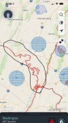