You are using an out of date browser. It may not display this or other websites correctly.
You should upgrade or use an alternative browser.
You should upgrade or use an alternative browser.
Missing GEO fence in UAV app that caused my drone to drown in the ocean
- Thread starter FlyBackOU812
- Start date
Michael Ainsworth
Well-Known Member
- Joined
- Apr 5, 2017
- Messages
- 1,008
- Reactions
- 942
- Age
- 73
I use the DJI app to check any restrictions that will directly affect my Drones, MP and Mavic Air 2, before flying.
The inbuilt DJI app used to operate the drones will go by that info in its data base.
I also double check any restrictions using the Open Sky app for Australia supplied by CASA. This app does not physically restrict the actual drone but shows the relevant restrictions pertaining to my intended flight area.
Open Sky doesn’t physically affect the drone but the DJI app does.
Really?With my mini 2 if I try to fly into a DJI map NFZ it gives a warning, then immediately tries to land.
If you try to power up and take off within a red Restricted Zone, it'll refuse.
If, for some reason (i.e. lack of GPS signal), it suddenly wakes up to find itself flying within a red Restricted Zone, it will immediately land.
But, if flying outside of such a zone, it should just bump up against the edge of the zone and refuse to go further.
DJI keeps changing the way these things work. They used to have altitude zones that sloped up at an angle the further you got from the runway ends. You could fly under the runway approaches as long as you didn't exceed the height limit. It wouldn't allow climbing any higher than that. The closer you got to the runway ends, the more and more the drone was forced down to the ground.
Now I believe, correct me if I'm wrong, those altitude zones off the ends of runways are now set at discrete steps. The red Restricted Zone starts right at the ground. Then the first grey altitude zone limits a flat 60m ceiling, then next one a 150m ceiling.
The best thing is to actually experiment. Take your drone to these locations to see how it behaves when interacting with DJI's GEO zones. If you're worried about getting arrested, take the props off (leave 'em at home) to prove you weren't actually attempting to fly anywhere illegal.
I live within the 5nm radius of an airport, in an approach zone. It will let me fly up to 60m in the approach zone, then when I hit the restricted zone about 120m from the house it just tries to land. I just fly back out of it and carry on. But it doesn't stop like hitting a wall, it immediately starts dropping altitude with a landing warning.Really?
If you try to power up and take off within a red Restricted Zone, it'll refuse.
If, for some reason (i.e. lack of GPS signal), it suddenly wakes up to find itself flying within a red Restricted Zone, it will immediately land.
But, if flying outside of such a zone, it should just bump up against the edge of the zone and refuse to go further.
DJI keeps changing the way these things work. They used to have altitude zones that sloped up at an angle the further you got from the runway ends. You could fly under the runway approaches as long as you didn't exceed the height limit. It wouldn't allow climbing any higher than that. The closer you got to the runway ends, the more and more the drone was forced down to the ground.
Now I believe, correct me if I'm wrong, those altitude zones off the ends of runways are now set at discrete steps. The red Restricted Zone starts right at the ground. Then the first grey altitude zone limits a flat 60m ceiling, then next one a 150m ceiling.
The best thing is to actually experiment. Take your drone to these locations to see how it behaves when interacting with DJI's GEO zones. If you're worried about getting arrested, take the props off (leave 'em at home) to prove you weren't actually attempting to fly anywhere illegal.
Interesting.I live within the 5nm radius of an airport, in an approach zone. It will let me fly up to 60m in the approach zone, then when I hit the restricted zone about 120m from the house it just tries to land. I just fly back out of it and carry on. But it doesn't stop like hitting a wall, it immediately starts dropping altitude with a landing warning.
It has been a while since I experimented with the various Geo zones using my Phantom 3 Pro. I've just stayed away from everything now with my Mini.
This is how it used to work with my Phantom. This airport had a NFZ of a 1-km radius. At the edge of that 1-km radius DJI allowed you to fly as high as 30m, with that ceiling increasing in a 30% slope as you move further from the airport. I can't remember how far out that altitude zone extended. If you were approaching the airport at some height, you'd eventually encounter the altitude ceiling and it would gradually force the drone down the nearer you got to the airport, until stopping you at max 30m height upon reaching the 1-km NFZ.
I think now the altitude zones are just flat ceilings at 150m, then abruptly stepping down flat to 60m. So does it just stop the drone at that edge, or force it to drop down to under 60m, at the transition?
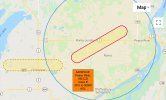
Here's the DJI GEO map for the Peace River Airport near your location. All of the 60m zones are already very close to the orange Enhanced Warning Zone. It should stop at that border and pop up another warning message. The Enhanced zone requires you to either turn around, or self-authorize by clicking to acknowledge you understand the risks and accept all responsibility for continuing.
This scenario then repeats when you next bump against the blue Authorization Zone, except to get in here you need an internet connection to self-authorize using your verified DJI account.
All of those steps need to happen long before you can get anywhere close to the inner red Restricted Zone which requires a much more stringent unlocking procedure with verifiable proof of your authorization to fly there.
You shouldn't be able to start up and take off anywhere within those zones without first doing those authorization steps. If you take off without authorization before the drone gets a solid GPS lock, it will automatically land the moment it gets a good GPS lock and wakes up to realize where it is.
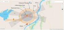

I put an X where my house is.Interesting.
It has been a while since I experimented with the various Geo zones using my Phantom 3 Pro. I've just stayed away from everything now with my Mini.
This is how it used to work with my Phantom. This airport had a NFZ of a 1-km radius. At the edge of that 1-km radius DJI allowed you to fly as high as 30m, with that ceiling increasing in a 30% slope as you move further from the airport. I can't remember how far out that altitude zone extended. If you were approaching the airport at some height, you'd eventually encounter the altitude ceiling and it would gradually force the drone down the nearer you got to the airport, until stopping you at max 30m height upon reaching the 1-km NFZ.
View attachment 123432
I think now the altitude zones are just flat ceilings at 150m, then abruptly stepping down flat to 60m. So does it just stop the drone at that edge, or force it to drop down to under 60m, at the transition?
Here's the DJI GEO map for the Peace River Airport near your location. All of the 60m zones are already very close to the orange Enhanced Warning Zone. It should stop at that border and pop up another warning message. The Enhanced zone requires you to either turn around, or self-authorize by clicking to acknowledge you understand the risks and accept all responsibility for continuing.
This scenario then repeats when you next bump against the blue Authorization Zone, except to get in here you need an internet connection to self-authorize using your verified DJI account.
All of those steps need to happen long before you can get anywhere close to the inner red Restricted Zone which requires a much more stringent unlocking procedure with verifiable proof of your authorization to fly there.
You shouldn't be able to start up and take off anywhere within those zones without first doing those authorization steps. If you take off without authorization before the drone gets a solid GPS lock, it will automatically land the moment it gets a good GPS lock and wakes up to realize where it is.
View attachment 123429
View attachment 123433
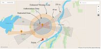
Sorry, that X isn't accurate. I'm just outside of the authorization zone, in the enhanced warning zone. It's when I fly into the authorization zone that the drone tries to land, not the restricted zone.
That is odd as it should just not let you enter the zone, just like the OP's did. It won't allow you to fly in, but it will allow you to yaw around and fly away from. The only time it should go into landing mode is if you are already in the zone...which is a whole different ball game of how you got in there in the first place.With my mini 2 if I try to fly into a DJI map NFZ it gives a warning, then immediately tries to land.
I was one zone off. I'm in the enhanced warning zone, just outside the authorization zone.That is odd as it should just not let you enter the zone, just like the OP's did. It won't allow you to fly in, but it will allow you to yaw around and fly away from. The only time it should go into landing mode is if you are already in the zone...which is a whole different ball game of how you got in there in the first place.
Thank you ZBip for your explanations and your time you put into this for me. This explains a lot and is exactly what I needed to knowHere are a few more examples of how confusing this can all be.
Our Canadian government posted a handy online "Drone Site Selection Tool". nrc.canada.ca/en/drone-tool/
In Canada, the only regulation (with a few notable exceptions) that applies to sub-250 micro-drones is:
"900.06 No person shall operate a remotely piloted aircraft system in such a reckless or negligent manner as to endanger or be likely to endanger aviation safety or the safety of any person."
Legally, there's no regulation saying you can't fly your sub-250 gram Mavic Mini across the runways at Ottawa International Airport (YOW), except that would certainly be considered reckless or negligent. There are however other flight restrictions that do apply to ALL aircraft, including sub-250 gram micro-drones, such as over prisons, or over our Parliament Buildings, or over the Prime Minister's summer cottage located in Gatineau Park, etc.
So here's the official "Drone Site Selection Tool" map for sub-250 gram micro-drones in my Ottawa area. The red-filled circles and rectangle are actual Flight Restricted Zones applicable to ALL aircraft. The other red-bordered areas are airports, aerodromes, or heliports. While not actually "illegal" to fly a Mavic Mini within those zones, it would almost certainly be considered reckless or negligent if you did. So, don't even try it! The yellow areas are locations where you're likely to encounter manned aircraft, so be careful and don't do anything stupid there.
View attachment 123408
For drones weighing greater than 250 grams you need to meet all sorts of other regulations, registration, and licensing requirements. For Basic Operations the official map looks like this. You're not allowed to fly within any control-zone, or within a certain radius of airports. All of the red areas are Stay-Out!
View attachment 123410
If you have fulfilled all of the more stringent regulatory requirements to obtain the licence for Advanced Operations, then the official map looks like this below. With an Advanced licence you can fly within control-zones, over prisons, and even over the Prime Minister's cottage, ONLY if you have coordinated such flights for approval with the proper authorities.
View attachment 123411
The maps above are the official versions of what's legal or not. Below instead is how DJI sees things. This is DJI's GEO zone map for my Mavic Mini. For sure it's useful as it does bear some resemblance to the actual official zones. But it's important to always be aware of these DJI zones because, rightly or wrongly, these are what are going to affect whether my Mini will actually take off and fly within these zones.
View attachment 123412
And to further confuse things, this is the same, but significantly different, DJI GEO zone map as it affects my Phantom 3 Pro, for which I need at least a Basic licence to legally fly in Canada.
View attachment 123413
I must have missed something, all the talk of NFZs but you are over the ocean with 10% battery??? and you get low battery RTH and the AC ascends to 40m to come home as it should. Did you cancel RTH, because it then drops and turns away from home after that?I'm not a new pilot and I know most of what I need to know about flying but ive noticed there are some pilots in here that are seasoned vets and this happened over the summer and ive never got a straight answer as to how I or any other pilot would have avoided this. I thought I did my due diligence by checking the area b4 I flew and it showed clear to fly in that area. Matter of fact it was the only place within miles that it showed had no warnings or anything. So flew out over the water to get video of my brother jumping waves on his Wave Runner not more than couple hundred feet out where the waves were cresting for him to jump and when it was time to come back on account of battery I was like 50 foot from land I the drone just stopped advancing forward. Had no idea what was going on cuz I had never had this happen B4 so I I went low and high and even tried to get a running start but it was like an invisible, impenetrable forcefield and ultimately it went in the drink and drowned. Is this a common thing in other places or was this one in million kinda thing. Im feeling it was. But still today many months later it still doesn't show on the UAV app and afterwards I checked another app and and it shows it on that app. How are we suppose to trust these apps to keep this from gapping and out of trouble. Ive still never gotten a straight answer on that question. Or would most pilots have had the same outcome? I'm gonna attach a screen recording of the flight log and a todays screenshot of the area from UAV app that still shows clear to fly and another one from B4ufly so you can see for yourself or look it up yourself ill have to get the coordinates for it if thats the case. Im still boggled by this plus the fact it still doesn't show so it could happen to someone else. I even messaged the people that run the app and they apparently don't care ?
View attachment 123229
Seems it simply runs out of battery and drops in the ocean while you are fighting to get on shore in a direction you can not go.
Thank you thats another big helpI use the DJI app to check any restrictions that will directly affect my Drones, MP and Mavic Air 2, before flying.
The inbuilt DJI app used to operate the drones will go by that info in its data base.
I also double check any restrictions using the Open Sky app for Australia supplied by CASA. This app does not physically restrict the actual drone but shows the relevant restrictions pertaining to my intended flight area.
Open Sky doesn’t physically affect the drone but the DJI app does.
That's a busy spot, in Geo-Zone terms.Sorry, that X isn't accurate. I'm just outside of the authorization zone, in the enhanced warning zone. It's when I fly into the authorization zone that the drone tries to land, not the restricted zone.
You're starting off under a 60m height restriction zone, already within the orange enhanced warning zone for Peace River, and then flying into the blue Authorization Zone. Is it possible that you're also within, or flying into, the orange enhanced warning zone of Grimshaw?
Each one of those DJI GEO zones should pop a message and stop your drone from crossing the transition into the zone, unless you have successfully authorized (or pre-authorized) your entry. It's only if you somehow managed to start up or cross into those zones without a good GPS lock, and the drone then wakes up to discover itself inside the zone without an authorized unlock that it would automatically land itself.
The frustrating thing is that "legally" none of those DJI zone restrictions actually apply to the sub-250 gram Mavic Mini in Canada. Technically, you are already inside the control zone of the Peace River airport, which controls from surface to 3000ft. But as long as you're not doing anything reckless or negligent, (or "likely to endanger aviation safety"!!) you'd only be annoying the tower asking every time if it's okay to fly your Mini in your own backyard.
That does sound like exactly what happened. But his original complaint was that he didn't know that NFZ was even there, because it wasn't shown on the B4Ufly app he was using for reference.Seems it simply runs out of battery and drops in the ocean while you are fighting to get on shore in a direction you can not go.
I think it's brave of people to post their stories of such mishaps, because we all can learn and profit from the misfortunes of others.
It's easy to judge from the comfort of our armchairs and think of what we might have done differently. But it's different when something completely unexpected happens in real time and you're forced to watch your drone drop into the sea with an exhausted battery as it mysteriously refuses to fly those extra few feet to safety on the beach.
I once had a moment of sheer terror and panic on one of my very first flights with my original Phantom-1. Luckily it ended well, but I only figured out much later, when studying the video, what I'd done wrong. But in the moment of full panic my mind went completely blank and I froze up when the Phantom didn't respond as expected. I still get embarrassed when watching this. There are at least ten things I should have done differently here...
The Grimshaw aerodrome has zero effect on my drone, no warnings pop up and the drone will go as high as it's software allows. There isn't an airport in town anymore, it used to be a grass strip but development has since taken over the area and the airstrip is long gone. I have flown at my buddy's place a bit northeast of me, and had to do the unlock thing to fly in his yard. Got a text sent to my phone, entered it into the app and got permission to fly up to 120m.That's a busy spot, in Geo-Zone terms.
You're starting off under a 60m height restriction zone, already within the orange enhanced warning zone for Peace River, and then flying into the blue Authorization Zone. Is it possible that you're also within, or flying into, the orange enhanced warning zone of Grimshaw?
Each one of those DJI GEO zones should pop a message and stop your drone from crossing the transition into the zone, unless you have successfully authorized (or pre-authorized) your entry. It's only if you somehow managed to start up or cross into those zones without a good GPS lock, and the drone then wakes up to discover itself inside the zone without an authorized unlock that it would automatically land itself.
The frustrating thing is that "legally" none of those DJI zone restrictions actually apply to the sub-250 gram Mavic Mini in Canada. Technically, you are already inside the control zone of the Peace River airport, which controls from surface to 3000ft. But as long as you're not doing anything reckless or negligent, (or "likely to endanger aviation safety"!!) you'd only be annoying the tower asking every time if it's okay to fly your Mini in your own backyard.
View attachment 123476
View attachment 123478
his place is the upper red X inside the authorization zone.
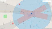
That's yet another example then. Even though the Grimshaw grass strip is gone, DJI's online GEO zone map still shows it as an Enhanced Warning Zone. You need to click the box below the online map to enable the display of those enhanced zones. They're disabled by default when you first load the page. You can also zoom in with satellite view. www.dji.com/ca/flysafe/geo-mapThe Grimshaw aerodrome has zero effect on my drone, no warnings pop up and the drone will go as high as it's software allows. There isn't an airport in town anymore, it used to be a grass strip but development has since taken over the area and the airstrip is long gone.
Also check the map in your DJI Fly app, bottom left corner. Click it twice to expand it to full screen. Give the drone enough time to achieve full GPS lock and the app's map should display all the GEO Zones in your area, including the orange Enhanced Warning Zones like Grimshaw.
You live in the perfect spot to experiment with all these different types of GEO zones. Wide open spaces with unobstructed sight lines, and no nearby Karens to get on your case accusing you of spying or other nefarious wrongdoings.I have flown at my buddy's place a bit northeast of me, and had to do the unlock thing to fly in his yard. Got a text sent to my phone, entered it into the app and got permission to fly up to 120m.
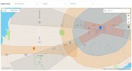
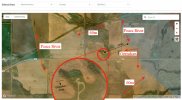
For the sake of this discussion, hypothetically speaking, let's say your place is circled red, as magnified in the image below. You're under the 60m height restricted GEO zone for the Peace River approach path. You are also inside the orange Enhanced Warning Zone for Peace River. AND, your house and driveway are also just barely inside the orange Enhanced Warning Zone for Grimshaw, which may be obsolete but does actually still exist on the DJI map.
If you walk a few steps North behind your house, you'd be just outside the edge of the Grimshaw zone. If you power up here, on the lawn North of the house, when the Mini establishes GPS lock it should warn you about both the 60m altitude restriction and the Peace River Enhanced Warning Zone. You should need to self-acknowledge that Enhanced Warning Zone before being allowed to fly.
Now if you take off from that spot North of the house, and fly South toward the house and driveway, you'd be entering the Grimshaw Enhanced Warning Zone. That should pop up yet another warning requiring you to again self-acknowledge and accept responsibility for all the "risks" involved before permitting you to enter the zone and before allowing you to fly over the house.
Then, if you fly approximately 500m North-East, you'll hit the edge of the blue Authorization Zone for Peace River. The drone should bounce off that limit too, refusing to even enter that zone. You first need to get the unlock text from DJI (like you did at your friend's house) before being able to enter (or take off within) that blue Authorization Zone. It's only if the drone somehow initially gets flying inside that zone without sufficient GPS lock, and then does get full GPS reception without prior unlock permissions, that it would cause the drone to autoland.
At least that's the way I understand it's supposed to work. I'd be itching to experiment here.
And remember, legally, none of those DJI GEO Zones actually apply to under-250 gram micro-drones. Just be careful to always keep in mind that someone (Karen) might interpret your actions to be "reckless or negligent" if you do get too close to the airport.
I'll find one of those screen recorder apps and make a couple flights according to your suggestions as soon as we get out of this deep freeze. When I bought my first mini I about crapped my pants when I looked up the drone maps, figured I wouldn't be able to even take off on my own property. All 320 acres are in some kind of "zone".
I checked OP's location in Airmap that he had issues, and that military base is marked off exactly as DJI has it.
DJI Geozone should create a wall that you can't cross, but as stated if you end up in it, it will land.
Two possible reasons I can think of that it lands when you reached the border:
1. Wind pushed you just enough inside.
2. GPS resolution inaccuracies where one moment you're outside, next minute you're inside.
In wind the Mini can be buffeted quite a bit but average position may be stable. That buffeting may be enough to be detected as being inside.
When I bought my first mini I about crapped my pants when I looked up the drone maps, figured I wouldn't be able to even take off on my own property. All 320 acres are in some kind of "zone".
I hear ya.
I used to fly my Phantoms making videos doing all sorts of experiments in our high school football field. Never caused anyone any problems, and never had anyone complain about me. Now it's all illegal. That field is just within the outer limits of the Ottawa YOW control zone. Even if I jumped through the required hoops to obtain a Basic Licence, I still wouldn't be allowed to fly within any control zone. I'd need an Advanced licence and permission from the Ottawa tower to fly there now. Sheesh.
I bought a Mavic Mini instead. But, DJI still sometimes pesters me their GEO zones. Luckily we now have a house on a lake far from any restrictions. Now I just need to watch out for the occasional float plane, or the water bombers sometimes operating from the next lake over.
If you're on iOS, I think they already have a built-in screen recorder function. I'm on Android and use the free "AZ Screen Recorder" app. I almost always leave that running and recording in the background whenever I fly. It's really useful if you later want to study any of the telemetry or error messages that may have popped up. It records sound too. That's handy for keeping a record of whatever "Karen" is yelling at you while you're trying to concentrate on your flying.I'll find one of those screen recorder apps and make a couple flights according to your suggestions...
Similar threads
- Replies
- 20
- Views
- 2K
- Replies
- 13
- Views
- 850
DJI Drone Deals
New Threads
-
-
FCC has updated the Covered List to not include Blue sUAS and American made sUAS
- Started by jaja6009
- Replies: 3
-
-
-


