This thread is four years old. It is doubtful you'll get a replyJohn-you launched/landed 3 mi from AZ state line on 163? Or by Forest Gump spot?
Can you launch/land near Monument Valley Airport(uncontrolled)
So confused…and don’t want any hassles
Thnx
You are using an out of date browser. It may not display this or other websites correctly.
You should upgrade or use an alternative browser.
You should upgrade or use an alternative browser.
Monument Valley
- Thread starter John Locke
- Start date
Hi Dale,Let me be another to praise this great video! I loved the flying, the scenery, and the music. The editing was spot on. I am not as a good a pilot in doing those circles around the mittens and buttes. Hopefully I won't crash into one of them. Have been flying for 2 years.
I happen to be personally very interested because I have just canceled my trip to Monument Valley after months of planning, because of the coronavirus. I canceled a three day stay at the View Cabins and a sunset tour as well. I hope to reschedule in September if corona is subdued. I really would appreciate any tips on this forum or as a conversation or off forum as to places where I could get shots with the Mavic 2 Pro without taking off from the park. Can you contact me?
Dale
Miami
I came across this old thread on the forum. I'm heading to Monument Valley, and sites around Moab in late March. Any suggestions or advice re legal places/ways to fly? Seems like a lot of the area is restricted to drones. Any advice would be greatly appreciated.
Jim
Philadelphia
The Navajo don't allow drones to be launched and retrieved on their land. If you're caught, you are under tribal law jurisdiction. You may have your drone confiscated, held hostage for $$. I never flew within the Navajo nation "park" in Arizona, I always launched and landed outside of their control, in Utah. However, I believe the whole area is actually under their control. So to fly relatively safe, I flew from the highway, over by Stagecoach monument in Utah. There are some road turnouts available in that area. I stayed in my car to control the craft, kinda hiding, as you don't want to be obvious to a passersby. On another flight I launched from the KOA campground nearby. If you're flying a Mini, that craft is pretty quiet. If you ascend to 100-150ft, you can't hear very easily. So when flying I try to stay at least that high in case I unknowingly fly over a tribe residence, so they can't hear it.Hi Dale,
I came across this old thread on the forum. I'm heading to Monument Valley, and sites around Moab in late March. Any suggestions or advice re legal places/ways to fly? Seems like a lot of the area is restricted to drones. Any advice would be greatly appreciated.
Jim
Philadelphia
You may want to check out Valley of the Gods nearby, a very pretty area. I think drones are acceptable there (not sure).
Last edited:
Hi John:The Navajo don't allow drones to be launched and retrieved on their land. If you're caught, you are under tribal law jurisdiction. You may have your drone confiscated, held hostage for $$. I never flew within the Navajo nation "park" in Arizona, I always launched and landed outside of their control, in Utah. However, I believe the whole area is actually under their control. So to fly relatively safe, I flew from the highway, over by Stagecoach monument in Utah. There are some road turnouts available in that area. I stayed in my car to control the craft, kinda hiding, as you don't want to be obvious to a passersby. On another flight I launched from the KOA campground nearby. If you're flying a Mini, that craft is pretty quiet. If you ascend to 100-150ft, you can't hear very easily. So when flying I try to stay at least that high in case I unknowingly fly over a tribe residence, so they can't hear it.
You may want to check out Valley of the Gods nearby, a very pretty area. I think drones are acceptable there (not sure).
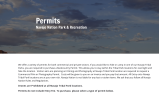
We has planned a great trip there but Covid canceled it. Of course Monument Valley is all Navajo land and the web site says drones are prohibited (see my attachment). I was able to secure a great motel, overlooking he monuments and really was sorry to lose that opportunity . If it is possible to fly nearby the boundaries, it would be a try. Read the 2nd to last bottom line of this attachment. I would book a private tour (Google to find guide). This way you will not waste time in scouting. My goal was to film timelapse sunrises and sunsets over the valley from my motel room. Using a DSLR and timelapse software.
Dale

GrayHornet
Well-Known Member
GroovyGeek
Well-Known Member
Thank you. Well done. My next task will be to goon Goggle Earth and find that Utah Highway north of the Tribal lands. We are planning to be in the area perhaps this fall. About how far from the launch did you have to fly for this spectacular scenery? Thanks
No need for Google Earth. The view from Forrest Gump viewpoint is THE iconic view of the American Southwest. The OP probably used one of the numerous pullouts along that road.
While I am not normally a stickler for VLOS laws, I have my own opinions about violating it over reservations.
No need for Google Earth. The view from Forrest Gump viewpoint is THE iconic view of the American Southwest. The OP probably used one of the numerous pullouts along that road.
While I am not normally a stickler for VLOS laws, I have my own opinions about violating it over reservations.
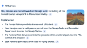
Regrettably, I found this on Google.
I have had several close calls with various native tribe police departments. They were not pleasant. I will not discuss further than that for fear of self incrimination.

GroovyGeek
Well-Known Member
Regrettably, I found this on Google.
I have had several close calls with various native tribe police departments. They were not pleasant. I will not discuss further than that for fear of self incrimination.
View attachment 180652
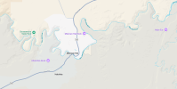
AI Summaries are NEVER to be relied upon for hard information, but in this case they are correct. I initially thought that US-163 is not part of the reservation, so the video only played it loose with VLOS rules but was not an outright violation of takeoff/landing restrictions. However a map check confirms that that is not the case. The first place where drone takeoffs are allowed is Mexican Hat. If the OP is making a living with their drone they will be well served to take down the video. I know professional photographers that have run into pedantic park rangers who, in response to various permit requests, go on their websites to ensure that the photographer has not skirted any laws.
GroovyGeek
Well-Known Member
Don't think you can fly at Goosenecks. State parks are exlcuded. However the Moki Dugway and Valley of the Gods are on BLM land... I think. If you have the right vehicle, there are a number of spur roads from UT-261 above the Moki Dugway that take you to the edge of the Valley of the Gods.I went back to look at the Mexican Hat location. *By the way do not miss Goosenecks but very crowed).View attachment 180653View attachment 180653
Here is a top-down view of the Moki Dugway
MARK (LI)
Well-Known Member
Don't be discouraged by the regulations about flying there ....it is a spectacular area.....although the word spectacular does not adequately describe how breathtakingly beautiful it is ....which is partly why the Native Americans hold it in such high esteem ...if you have a decent DSLR or mirrorless camera you will still get fabulous photographsHi Dale,
I came across this old thread on the forum. I'm heading to Monument Valley, and sites around Moab in late March. Any suggestions or advice re legal places/ways to fly? Seems like a lot of the area is restricted to drones. Any advice would be greatly appreciated.
Jim
Philadelphia

Yes, it's clear the tribal park areas in Arizona restrict launch and retrieve of drones. The places I flew from were in Utah, outside the tribal park, along the highway or at the KOA. They don't control the airspace over their parks, only the launch and retrieval of their land. Search "Monument Valley" on Gmaps and you can see the tribal park boundaries. However the Navajo nation does extend into Utah, it's just not within the park boundary. That's why you should always fly stealth.Hi John:
We has planned a great trip there but Covid canceled it. Of course Monument Valley is all Navajo land and the web site says drones are prohibited (see my attachment). I was able to secure a great motel, overlooking he monuments and really was sorry to lose that opportunity . If it is possible to fly nearby the boundaries, it would be a try. Read the 2nd to last bottom line of this attachment. I would book a private tour (Google to find guide). This way you will not waste time in scouting. My goal was to film timelapse sunrises and sunsets over the valley from my motel room. Using a DSLR and timelapse software.
Dale
View attachment 180642
GroovyGeek
Well-Known Member
Agreed, same is true of pretty much all of Southern Utah, maybe even to a greater extent than Monument Valley. Areas that would be a National Park anywhere else are drive throughs on the way to even more jaw dropping area. Glenn Canyon is, in some ways, more visually impressive than the South Rim of the Grand Canyon.Don't be discouraged by the regulations about flying there ....it is a spectacular area.....although the word spectacular does not adequately describe how breathtakingly beautiful it is ....which is partly why the Native Americans hold it in such high esteem ...if you have a decent DSLR or mirrorless camera you will still get fabulous photographs View attachment 180654
Yes, it's clear the tribal park areas in Arizona restrict launch and retrieve of drones. The places I flew from were in Utah, outside the tribal park, along the highway or at the KOA. They don't control the airspace over their parks, only the launch and retrieval of their land. Search "Monument Valley" on Gmaps and you can see the tribal park boundaries
Just looked at the locations you named in your video. You shot Valley of the Gods and it's vicinity, not Monument Valley. You are correct, that is legal. Monument Valley is the area in AZ around Kayenta
AlexRomanov
Active Member
Awesome! I will be on this area maybe after 2-3 year. Could you please advise me what software you are using for colouring - Im just investigate this processThis video of Monument Valley is one of my best, IMHO. Hope you like. Please critique. I'm still honing my editing skills. I switched to Resolve recently, as Premiere Pro (I've use it for 3yrs) isn't that much better IMO, and Resolve is free. This video was a true joy to fly and edit, since I had such a grandioso subject to capture. I'm definitely going back there someday to fly again.
Similar threads
- Replies
- 12
- Views
- 521
- Replies
- 6
- Views
- 1K
- Replies
- 31
- Views
- 2K
- Replies
- 9
- Views
- 2K
- Replies
- 1
- Views
- 758
DJI Drone Deals
New Threads
-
Air 3 Above the Danube – From the Wachau to Bratislava
- Started by sven_D
- Replies: 0
-
-
-
Can't Download GO 4 App
- Started by Steve LaBranche
- Replies: 3
-
A great deal for a really good book with aerial photography
- Started by AMann
- Replies: 4
Members online
Total: 3,176 (members: 8, guests: 3,168)


