DJI Mavic, Air and Mini Drones
Friendly, Helpful & Knowledgeable Community
Join Us Now

Jim D

Well-Known Member
Joined
Sep 10, 2018
Messages
240
Reactions
870
Age
69
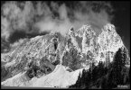
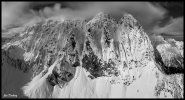
I hiked up to Lake Serene below Mt. Index off of Hwy 2 in WA last week. Not a spectacular sunrise I was hoping for but got some good shots of the dramatic north and east faces of this incredible mountain. All drone shots are RAW panos processed and stitched in computer.
Lk-Serene-087-Pano-bw.jpg
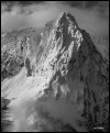
Here is the typical view from the lake taken with my Sony A7rII
Lk-Serene-drone-002a-Pano-bw-hd.jpg
Drone view 1

Lk-Serene-drone-123a-Pano-BW.jpg
North Face
 
Hi Jim, congratulations for the shots. The dramatic tone that black and white manages to convey is also beautiful. Can you give us more information on the type of panoramas you did for the 2 shots? Thank you.
 
  • Like
Reactions: John235
I hiked up to Lake Serene below Mt. Index off of Hwy 2 in WA last week. Not a spectacular sunrise I was hoping for but got some good shots of the dramatic north and east faces of this incredible mountain. All drone shots are RAW panos processed and stitched in computer.
Hi Jim,
wow outstanding photos of an amazing looking mountain, fantastic compliments ??
cheers Paul
 
Thanks for the comments guys.

John, for my panos I shoot all RAW manually framing the shots. The first drone shot was 3 rows of 4 I think. I always shoot manual exposure, normally f4 with shutter speed adjusted to not blow out the highlights. I process all the shots in ACR then take them back into PS where the bursts are layered and median blended to reduce noise. Those shots are saved as tif and brought back into ACR where they are stitched into a pano and final adjustments made.
 
Lycus Tech Mavic Air 3 Case

DJI Drone Deals

Forum statistics

Threads
134,438
Messages
1,594,777
Members
162,975
Latest member
JNard1