DJI Mavic, Air and Mini Drones
Friendly, Helpful & Knowledgeable Community
Join Us Now

New Maven / Litchi Waypoint Mission Converters

DJ Wes

Well-Known Member
Joined
Feb 6, 2019
Messages
567
Reactions
1,208
Location
Springdale, AR, USA
Site
www.litchiutilities.com
Attention Litchi and Maven Users

New tools have been developed to facilitate the conversion between Maven’s CSV format and Litchi’s CSV format.

Maven’s Mission Planner has recently undergone several updates, bringing it to a feature set comparable to Litchi’s Mission Hub (v2). The Mission Planner enables users to create both waypoint missions and photogrammetry missions. In addition to waypoints, it supports features such as Points of Interest (POIs), waypoint actions, and above-ground settings, among others.

There are several key differences between Maven’s and Litchi’s CSV formats. For instance, global parameters like mission speed and mission finish actions are included in Maven’s CSV files but are absent from Litchi’s.

These new conversion tools provide an efficient way to migrate waypoint missions between the two platforms.

These new conversion tools are available here:

Litchi Mission Utilities
 
@DJ Wes,
This term "Maven" ?

What I'm I or others missing?

Rod ..
 
@AnzacJack ,
Thanks man, that is Kool, but not cold. Thumbswayup

Wow, would have been a lot simpler to me, maybe others, if the OP posted that link.:rolleyes:

Rod ..
 
  • Like
Reactions: AnzacJack
is there a way to convert files bigger than 30kb?

since my dji fly app does not recognize settings for foto interval when creating the kmz out of litchi hub id like to create a waypoint for every photo when exporting from maven, wich kind of always results in files bigger than 30kb..
 
is there a way to convert files bigger than 30kb?
For which converter? I've increased the maximum file size to 50KB for both the "Litchi to Maven" and "Maven to Litchi" converters.
since my dji fly app does not recognize settings for foto interval when creating the kmz out of litchi hub id like to create a waypoint for every photo when exporting from maven, wich kind of always results in files bigger than 30kb..
The WPML language does support distance/time intervals but like you have found, DJI's implementation in DJI Fly does not appear to support them.
 
At first thanks a lot for your fast reply! :)

I used the Maven Waypoint to Litchi Converter when running into the 30kb limit.

For better understanding, the reason why I ran into the problem with converter size limitation is as following.

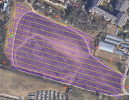
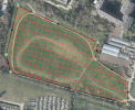
I used Maven to initially create a waypoint mission for areal imaging with less than 90 degrees (like 45 to 60, for better capturing of buildings facades, since I further combine it with terrestrial imaging). The only reason for me using Maven was, that it also supports grid filling (which I wasnt able to find in Litchi Hub) as shown on the following screenshots (on my empty "testfield" for better visibility).

Litchi Hub:
MavenRoute – Mozilla Firefox 28.09.2025 02_27_31.png

Maven:
MavenRoute – Mozilla Firefox 28.09.2025 02_27_30.png

Since the DJI Fly App wasnt able to support the distance/time intervals as you mentioned, I exported a csv with waypoints for each photo position out of Maven, because when converting it and importing into Litchi (which I had to do, since Maven isnt able to export kmz files) I would be able to select all waypoints and add the imaging action to all of them with just two clicks.
Since the shown "testfield" mission ended up with 770 waypoints and a filesize of around 100kb I was not able to convert it, which led to my initial question here.
As I was eager to find a solution / workaround, I split up the exported mission with notepad++ into four separate files, so every one of them got below 30kb (three with 200 WPs and one with the remaining 170 WPs). I then converted every one of them with the Maven to Litchi Converter, combined them with notepad++ and imported them into Litchi Hub where I was able to add the mentioned image capturing action and export it to kmz to get the intended result.
The 50kb filesize limit already easens up my workaround, since I wouldnt need to split up the Maven export as many times.
I hope youll understand what I wanted to achive, maybe Im also completely missing something, I just dont know..

Thanks again for your help and the great utilities you provide for Litchi, the Spiral Mission Creator so far worked like a charm!
Best regards

EDIT:
I did some more testing and research and another workaround would be duplicating the Litchi Hub mission and changing the orientation ±90 degrees to fly the grid in separate mission. Which actually would be way easier than my initial workaround..
Theres only one follow up question:

In the old Litchi Hub there was an option for reversing the mission as finish action
Litchi Hub OLD_finish-action.png
as well as in the offline version by Namirda, where you could invert the waypoint numbering
Litchi Hub OFFLINE_reverse.png

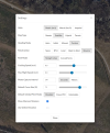
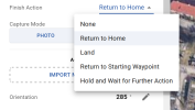
In the new Litchi Hub theres no reverse option on finish
Litchi Hub NEW_finish-action.png
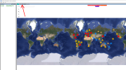
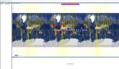
and if I try to open my saved project with the old online or offline hub, to either set the finish action to reverse or invert the waypoint numbering the mission is spread all around the globe and theres no way to get it out properly again
Litchi Hub OFFLINE_import-error.png

Any suggestions on that topic?

Thanks!
 
Last edited:

DJI Drone Deals

New Threads

Members online

Forum statistics

Threads
138,683
Messages
1,639,976
Members
167,088
Latest member
samueljmcgeesr
Want to Remove this Ad? Simply login or create a free account