DJI Mavic, Air and Mini Drones
Friendly, Helpful & Knowledgeable Community
Join Us Now

Newbie joining from NY

Had a couple scary moments already when it was not facing the direction I thought it was (I looked down at the controller, then looked back up and couldn't see it right away, then flew it away thinking I was bringing it closer!) Thank goodness for the avoidance system, and return to home.
If you have a scary moment like that again, STOP, THINK, and BREATH. In most cases, your drone will just hover in place (unless you put it up in a strong wind…).

You have several options here:…

If you have set your RTH altitude correctly (higher than all obstacles around you: trees, towers, wires, buildings, etc…) and you waited for the Drone to get sufficient satellites so the controller set your Return to Home Point, then just press the Return to Home Button… And your drone will come home like a "Good Little Drone…"

Another option is to slowly Yaw (turn the drone around 360 degrees) and look in the video feed to see if you can see your location (where you took off from (parking lot, park, street, etc…) and then you might be able to just fly home…

Still another option is the Atti Mode (bottom left of the screen) where your drone appears as a Blue Triangle and your Home Point appears as a Circled "H" and you (with the controller in your hands) appears as a Blue Circle with a little triangle for a hat. The hat is actually an arrow that shows which way your controller is pointing relative to your drone. You always want to be pointing at your drone for maximum signal strength. You want to yaw your drone around so that the Blue Triangle (your drone) is pointing at your Home point or you and then fly straight back…

Finally, you switch over to Map View and in this case you will see a whole bunch of squiggly blue lines on a map of your area (it could be very detailed or pixelated depending on how careful you were before you took off.. The Blue Lines indicate your flight path from take off until now. If you just took off and flew straight out, then the flight path will be a straight line, not likely… Again, Yaw (rotate your drone so the Blue Triangle is pointed at you or the Home point…

Below is the link to all of the downloads offered by DJI for the Mavic 2 Pro/Zoom, including the User Manual.

After you read the Manual, read it again, you will be surprised what you missed the first time and you will be better prepared for that first "scary moment…"


At this point, you are not ready to fly a drone unassisted. I would set your maximum range and height to a relatively short distance, 50-meters or 150 foot range and height until you can fly your drone frontwards and backwards, coming and going…

Good Luck!
 
Last edited:
  • Like
Reactions: wjkrysak
If you have a scary moment like that again, STOP, THINK, and BREATH. In most cases, your drone will just hover in place (unless you put it up in a strong wind…).

You have several options here:…

If you have set your RTH altitude correctly (higher than all obstacles around you: trees, towers, wires, buildings, etc…) and you waited for the Drone to get sufficient satellites so the controller set your Return to Home Point, then just press the Return to Home Button… And your drone will come home like a "Good Little Drone…"

Another option is to slowly Yaw (turn the drone around 360 degrees) and look in the video feed to see if you can see your location (where you took off from (parking lot, park, street, etc…) and then you might be able to just fly home…

Still another option is the Atti Mode (bottom left of the screen) where your drone appears as a Blue Triangle and your Home Point appears as a Circled "H" and you (with the controller in your hands) appears as a Blue Circle with a little triangle for a hat. The hat is actually an arrow that shows which way your controller is pointing relative to your drone. You always want to be pointing at your drone for maximum signal strength. You want to yaw your drone around so that the Blue Triangle (your drone) is pointing at your Home point or you and then fly straight back…

Finally, you switch over to Map View and in this case you will see a whole bunch of squiggly blue lines on a map of your area (it could be very detailed or pixelated depending on how careful you were before you took off.. The Blue Lines indicate your flight path from take off until now. If you just took off and flew straight out, then the flight path will be a straight line, not likely… Again, Yaw (rotate your drone so the Blue Triangle is pointed at you or the Home point…

Below is the link to all of the downloads offered by DJI for the Mavic 2 Pro/Zoom, including the User Manual.

After you read the Manual, read it again, you will be surprised what you missed the first time and you will be better prepared for that first "scary moment…"


At this point, you are not ready to fly a drone unassisted. I would set your maximum range and height to a relatively short distance, 50-meters or 150 foot range and height until you can fly your drone frontwards and backwards, coming and going…

Good Luck!
Thanks, LoudThunder, that is exactly the advice/help I needed. I actually used return to home to get it back, but it went up to 160 ft (as programmed) and there were high winds up there so I got a message about that, which made it a bit scary since I couldn't see it at first but then suddenly all was well. Hadn't learned about the map yet...
 
there were high winds up there so I got a message about that, which made it a bit scary since I couldn't see it at first
Ok, here is some more advice, there are two Apps to use before you fly, they are UAV Forecast and Winds.com.

The UAV Forecast should be configured before you use it, just click each block (ie: Wind, Cloud, etc…) and you set the conditions that you find acceptable, check the user manual for which satellites your drone uses and turn on or turn off those in the Satellites… The Mini 2 does not use the Chinese Beidou Satellites…

Windy.com offers so much information, even the tides in your section of the Hudson…

Winds can be so tricky, especially in your area with valleys and tall hills. One of the things I do to check the wind before I fly by carefully flying my drone straight up a little at a time…

I lift off, yaw,(turn) my drone so it is facing North and you need to know which way is north… I then fly up to 50' and look at the Attitude (Atti) gauge, it will indicate if your drone is having to tilt in some direction or other to remain in one place, if OK, I fly up to 100' and do this again, check the Atti gauge and look to see fi the drone is struggling and so forth …

IF you do not know what I am talking about, go to your kitchen table, turn on the drone and controller, DO NOT start you motors!!! Now turn your drone around so the drone is facing North… Now just tilt your drone down by hand so the nose is slightly lower than normal. Look at the atti gauge, notice that the Blue horizon raised up. That is what you would see if the wind was blowing from the North and your drone had to fight a head wind.

Do the same by tilting the drone so it's nose is high. The Blue Horizon will drop on the gauge and that indicates a tailwind from the South.

Tilt the drone so the right side is lower and that a widn from the east… and do the same for the left (West Wind…)

You just have to figure just how much your drone will tilt is a strong wind. I suggest when the wind is strong at ground level, do this at about 5' just to use to how your drone reacts…

Good Luck, Watch lots of Bad Blooper Videos so you learn from others mistakes… And always take your time before you take off to ensure you gave your drone plenty of time to get the satellites and set the home point.

And do not be like a friend of mine who set up his drone at the park while sitting in a pavilion. He then took off from the table and flew out. His mistake was getting lazy and he used RTH and did not pay a whole lot of attention as the drone came home, only to land on the roof of the pavilion… He went home and got a ladder to get his drone off the roof, it would not restart at the angle it landed at…
 
Hadn't learned about the map yet...
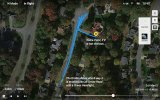
Here is a Map, as I wrote the Blues Squiggly line is the path the drone has flown. The Drone Icon is the Blue Arrow Head with a Green Headlight and that shows you which way the drone is pointing... The Atti gauge shows the controller direction.

After you fly and land, Click the main screen, Profile, More, and all your flights will be shown and you can play them like a video to see where you flew, how high, how fast, how far... etc...

map.jpg
 
  • Like
Reactions: HenryMow
Welcome to the forum! :)
 
Lycus Tech Mavic Air 3 Case

DJI Drone Deals

New Threads

Forum statistics

Threads
134,444
Messages
1,594,835
Members
162,979
Latest member
paul44509