DJI Mavic, Air and Mini Drones
Friendly, Helpful & Knowledgeable Community
Join Us Now

Oops after overlooking a Litchi mission planning detail

EricF

Member
Joined
Nov 21, 2021
Messages
24
Reactions
15
Location
Quebec, Canada
I'd planned a 6-minute circuit to get video of a friend's cottage nestled in trees near a frozen lake. All looked well, with the elevation of the waypoints over the forested area set to 45m (~150ft), so well above even the tallest pine trees. Just to be sure though, before starting the mission, I put my Mini 2 up to 45m and everyone agreed that it was definitely above all trees.

Waypoint #1 was 10m above the ice about 20m in front of the dock, so I brought it down to get a picture of my friend & his 2 grandchildren before invoking the mission.

Waypoint #2 was 25m up, but as the Mini 2 climbed to reach waypoint #3 at 40m, its path intersected with a pine tree. As a child's voice was calling out "Its gonna hit the tree!" I was frantically trying to abort. Too late: we all saw it hit a branch, then tumble into dense foliage!

The camera was still running, so we could see it was resting on one side with pine needles waving around, but we couldn't see it (even with binoculars). However, I was able to get the sensor details from AirData to determine that it had registered an event at 99ft (30m), then a couple of seconds later, another event at 70ft (21m). The first was probably when the prop struck the branch; the second was likely related to a displayed warning that the angle was too steep to fly.

From directly below, I noticed a squirrel venturing out on a limb far above. I'd switched over to DJI Fly by then to be able to turn on the buzzer, so when I hit it, the squirrel ran back... then tentatively started out again. Another buzz & another run: I still couldn't see it, but now we knew where Mini 2 was 70 feet up.

Luckily I know an arborist & professional tree-climber, who agreed to do a rescue climb the next morning. The kids found the tree climbing much more exciting than the aborted drone flight; my tree-climbing friend can now add "drone rescue" to his list of services; and I know not to ever overlook the ascent path when gaining altitude!

Oh, and Mini 2 after its night aloft? A right rear prop had a tip broken off, but with a new battery, it started normally — and I haven't encountered any problems since replacing the prop pair.

The Litchi mission plan: the red arrow shows how far it got!
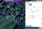
Crash mission detail anon.jpg
Way to tall to climb...
Crash tree area.jpg
...unless you have the gear and know how to do it safely!

Treeclimber.JPG
 
Eric, were you flying IOS Litchi Beta or the new release below?

Also, I read on another forum that you now to have to fly the mission to create waypoints which defeats a lot of it's benefits IF it is true. I wanted to plan a mission on my Macbook Pro and sync with IOS devices.

Can someone shed some light on this?
_______________________________________________
1648612847657.gif


Attachments

  • 1648612609323.gif
    1648612609323.gif
    47.5 KB · Views: 13
Also, I read on another forum that you now to have to fly the mission to create waypoints which defeats a lot of it's benefits IF it is true. I wanted to plan a mission on my Macbook Pro and sync with IOS devices.

Can someone shed some light on this?
You don't need to fly a mission to make a path of waypoints. It would be cool if you could...
 
You don't need to fly a mission to make a path of waypoints. It would be cool if you could...
As Dronut stated you do not have to fly a mission, it all can be done in Litchi Hub sitting at your computer at home but there is a option to actually fly the mission first and use this web page to generate waypoints after the flight by using the CSV file from airdata. Kind of a cool option.

 
You don't need to fly a mission to make a path of waypoints. It would be cool if you could...


Unless something has drastically changed (And I'm not saying it hasn't) you can absolutely fly and create waypoints within Litchi.

Edit: Unless it's a limitation with the Mini line of Mavics which I'm not familiar with. . . .
 
  • Like
Reactions: umanbean
Unless something has drastically changed (And I'm not saying it hasn't) you can absolutely fly and create waypoints within Litchi.

Edit: Unless it's a limitation with the Mini line of Mavics which I'm not familiar with. . . .
Nothing has changed @BigAl07 , planning a mission in your computer using the mission hub with the Mavic line (Mini included) is perfectly doable.
 
  • Like
Reactions: BigAl07
Unless something has drastically changed (And I'm not saying it hasn't) you can absolutely fly and create waypoints within Litchi.

Edit: Unless it's a limitation with the Mini line of Mavics which I'm not familiar with. . . .
MANUAL PLANNING WHILST FLYING

(When using a Mini 2/Mavic Air 2/Air 2S)
In the Litchi App set the function button (KEYS) of the remote controller to ‘Waypoint at Aircraft’.

In Waypoint Mode tap the onscreen Mission Setting button and set:
-Heading Mode to ‘Custom(WD)’
-Finish Action
-Path Mode
-Cruising Speed
-Default Gimbal Pitch Mode to ‘Interpolate’
-Rotation Direction to ‘Managed’

Now fly your drone manually to a point of your interest (not a POI) and aim (frame) the camera.

Press the Function button to create a waypoint.
This waypoint will include the position and direction of the drone AND the camera’s pitch angle (Gimbal Pitch).
Fly to the next location and do the same (up to a maximum of 99 waypoints).

When there is an obstacle between any of 2 waypoints of your interest, you have to include waypoints whilst flying around it.

When you’re done flying, save this created mission and run (fly) it.
You may possibly have to fine tune it either on your phone or in the mission hub.
Like:
In Mission Settings:
-Finish Action
-Path Mode
-Cruising Speed

In Waypoint settings:
-Speed
-Curve Size

Advantages using this method:
-You can actually frame a subject realtime, no guessing of distance and camera angle.
-You are aware of any potential obstacles and deal with them.
-Most likely NO unexpected control signal loss trouble with VSC-drones.

e514d00ef76c92933f24628040d7a2d5228536be.jpeg
 
Good to know about being able to save waypoints for a mission during a test flight @Agustine !

To @DroneSolutions question: I'm using the Android version (Pixel 4XL with current version of Litchi), and all of my missions (so far) have been set up using the Litchi mission hub running in a Chrome browser, with the "Chrome Litchi Virtual Mission" extension to allow me to export a mission to Google Earth so it can be "played". (I'm using it on Windows 10 Pro 64-bit.)

Since support for iOS is apparently now available, you should be able to create your mission on your Mac and save it to the Litchi cloud (you need to set up an account for that as part of running Litchi). I highly recommend also setting up an account with AirData so your flight telemetry is synched and available immediately after for analysis.

My tips for making Litchi missions? Start with the "Settings" button to set the overall default settings to apply to the mission (like cruising speed, path mode, "use online elevation", etc.). If you are using points of interest (POIs), set them roughly next (by right-clicking) because by default, waypoints will point to the closest POI. Create waypoints by left-clicking (and click "Delete" in the dialog if you make one accidentally). If you want an intermediate waypoint between two already set up (for example, to add one in the middle to take a photo), click the "Insert" button on the first waypoint's dialog: the new one will be inserted halfway between it & the next one.
 
  • Like
Reactions: umanbean
After this experience, I bet you will be hard to crash again.

I hope to share my own tips here, too.

Prior to planning any autonomous flight to a new location, I used to take sphere 360 panorama pictures with different altitudes.

The process is something like this:

Start the drone ==> Climb to 20M ==> take picture ==> Climb to 25M ==> take picture ....

It takes about 5 minutes to 10 minutes to do the inspection. And, after reviewing the inspection pictures, I will understand the location very clearly. Doing this way is pretty easy to make "no-crash-at-all" flight plans.
 
  • Like
Reactions: EricF and umanbean
Sorry....been down with a persistent virus...not C19...I appreciate the feedback. Just like different cable television sources you can often get misinformation from forum postings or I am the one who misunderstands what is being said. The weather has been horrible in the Chicago suburbs and have not been able to kick the tires of the new Mini 2 Litchi release. On one of the few nice, flyable days, I have had commitments preventing me from trying it. I usually don't try a new flight app release for any of my drones until it's been out for a few weeks. But will give the new release a try on my 1st decent day. Thank you.
 
MANUAL PLANNING WHILST FLYING

(When using a Mini 2/Mavic Air 2/Air 2S)
In the Litchi App set the function button (KEYS) of the remote controller to ‘Waypoint at Aircraft’.

In Waypoint Mode tap the onscreen Mission Setting button and set:
-Heading Mode to ‘Custom(WD)’
-Finish Action
-Path Mode
-Cruising Speed
-Default Gimbal Pitch Mode to ‘Interpolate’
-Rotation Direction to ‘Managed’

Now fly your drone manually to a point of your interest (not a POI) and aim (frame) the camera.

Press the Function button to create a waypoint.
This waypoint will include the position and direction of the drone AND the camera’s pitch angle (Gimbal Pitch).
Fly to the next location and do the same (up to a maximum of 99 waypoints).

When there is an obstacle between any of 2 waypoints of your interest, you have to include waypoints whilst flying around it.

When you’re done flying, save this created mission and run (fly) it.
You may possibly have to fine tune it either on your phone or in the mission hub.
Like:
In Mission Settings:
-Finish Action
-Path Mode
-Cruising Speed

In Waypoint settings:
-Speed
-Curve Size

Advantages using this method:
-You can actually frame a subject realtime, no guessing of distance and camera angle.
-You are aware of any potential obstacles and deal with them.
-Most likely NO unexpected control signal loss trouble with VSC-drones.

View attachment 146022
When you say (as a beginner to this) - "When there is an obstacle between any of 2 waypoints of your interest, you have to include waypoints whilst flying around it." If you are planning out a flying session on yr PC, and are unsure of elevation when you already have a hint that destination is higher than departure spot....what are the options....cause I've been told by a friend Google Earths .kmls will allow elevation, but does Litchi import these Google Earth things to help with your mission...?
 
As I understand it, both Litchi and Google Earth access the same topographical database that shows ground height as distance from mean sea level.

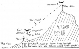
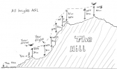
Consider flying a Litchi mission at, for example, 30m above the ground level of your starting point. In this mission there is a hill that at its highest is 80m above your starting point. Make sure to (at least) include a waypoint on the top of the hill that is also 30m above ground level.
1653763751694.png

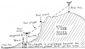
The reason why I say "at least" is that you cannot be certain that your drone and the hill both rise at the same rate - for example, if the highest point on your hill had an almost vertical cliff in front of it.
1653763802760.png

We would need to add waypoints earlier in the mission to make sure we get above the obstacle.
1653764008698.png
 

DJI Drone Deals

New Threads

Forum statistics

Threads
134,560
Messages
1,596,272
Members
163,062
Latest member
rstegner
Want to Remove this Ad? Simply login or create a free account