I'm new to mapping but not new to gigapixel photography. I am trying to create high resolution top down photography of cityscapes and have been doing testing in my neighborhood to try to get my settings and techniques figured out.
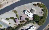
I took the attached photo using Copterus with my Air 2S. It took 200 photos from 200 feet up and 70% overlap. (The attached photo is low res for posting purposes, the original photo is 371 megapixels.)
I stitch the photos using Microsoft ICE, using the planar mode. It does a great job, except for the houses. The perspectives on the houses look strange. They look tilted and not top down, and some houses you can see walls from both the east and west side at the same time! Any tips on how to prevent this? I thought having so much overlap would help, but I guess not.
Thank you!
-Weston