


You are using an out of date browser. It may not display this or other websites correctly.
You should upgrade or use an alternative browser.
You should upgrade or use an alternative browser.
Question everyone is avoiding..what distance do we get from CE in the uk
- Thread starter Scoobychief
- Start date
Yorkshire_Pud
Well-Known Member
was hoping for a reply not a question, saying it because i cant see it in the threadsWhy do you say it is the question everyone is avoiding?

Yorkshire_Pud
Well-Known Member
Ahwas hoping for a reply not a question, saying it because i cant see it in the threads
Maybe folks aren't keen on risking a drone the just paid £800+ for.
@Scoobychief ,you will have to wait till windswept robert ,does a video about it, whatever it turns out to be, its going to be on a par with the Air 3, with which it shares the new 04 transmission system
Rilot
Well-Known Member
- Joined
- Oct 13, 2016
- Messages
- 279
- Reactions
- 321
- Age
- 49
Does it matter? We're not supposed to fly BVLOS anyway.Ok so the elephant in the room, without having to do an fcc hack for the mini 4 which i presume wont exist for a while what distance are people getting right out of the box in CE mode in the uk?
I flew a few laps of my house last night and the signal was stronger than with the Mini 3 Pro for sure. I used to get the occasional drop out when turning the craft. Not with Mini 4.
It will depend entirely on the environment you fly in.what distance are people getting right out of the box in CE mode in the uk?
Fly in an urban environment and it won't be anything amazing.
Fly in an environment with no wifi interference and it will be much more.
lol I am wondering the same thing before I hit that buy button.Ok so the elephant in the room, without having to do an fcc hack for the mini 4 which i presume wont exist for a while what distance are people getting right out of the box in CE mode in the uk?
People will say it does not matter because we shouldnt be flying BVLOS anyway. Lets not forget that how far out it can go without drop-outs also gives an indication on signal penetration, and how stable the transmission will be when the drone is behind trees and other obstacles. So it should definitely be talked about more.
Yorkshire_Pud
Well-Known Member
Should the discussion be about absolute range or should the discussion be about the reliability of the connection within the legally applicable limits?lol I am wondering the same thing before I hit that buy button.
People will say it does not matter because we shouldnt be flying BVLOS anyway. Lets not forget that how far out it can go without drop-outs also gives an indication on signal penetration, and how stable the transmission will be when the drone is behind trees and other obstacles. So it should definitely be talked about more.
Personally I think discussion of absolute range is, to some extent, "waving a red flag in front of a bull" and encouraging rule makers to legislate with the thought of introducing a mandatory "distance from the home point" limits.
The spectre of an enforced 120m relative to the home-point ceiling, is looming. It's not a great step to an enforced x00m from the home-point range limit.
@Yorkshire_Pud ,excuse my ignorance ,but as far as i can tell it has always been the case that the drone will geofence at 396 ft directly above the home point, what you are saying, is that it will know somehow ,what the elevation of the ground beneath itself is, and prevent the drone from exceeding that limit ,maybe i have misunderstood what is actually being proposed?
So currently the drone is able to know when it is 120m above home point and provide a warning message. There is also a setting to select a set max altitude up to 500 metres.@Yorkshire_Pud ,excuse my ignorance ,but as far as i can tell it has always been the case that the drone will geofence at 396 ft directly above the home point, what you are saying, is that it will know somehow ,what the elevation of the ground beneath itself is, and prevent the drone from exceeding that limit ,maybe i have misunderstood what is actually being proposed?
I think what he is saying is, there is now legislation being put forward to put a blanket geofence on all drones at 400ft so users will no longer be able to set it to go higher than that and thus discussing range and signal strength could mean regulators will put a blanket cap with the horizontal distance in the near future also which would make Ocusync’s signal strength obsolete to some degree. I mean if it came to that, the hobby is pretty much dead and buried at that point imo.
solidhouse
Well-Known Member
Hopefully, either drone-hacks or nolimitzdrones steps up and provide some hacks.So currently the drone is able to know when it is 120m above home point and provide a warning message. There is also a setting to select a set max altitude up to 500 metres.
I think what he is saying is, there is now legislation being put forward to put a blanket geofence on all drones at 400ft so users will no longer be able to set it to go higher than that and thus discussing range and signal strength could mean regulators will put a blanket cap with the horizontal distance in the near future also which would make Ocusync’s signal strength obsolete to some degree. I mean if it came to that, the hobby is pretty much dead and buried at that point imo.
Yorkshire_Pud
Well-Known Member
What do you mean by "geofence"?excuse my ignorance ,but as far as i can tell it has always been the case that the drone will geofence at 396 ft directly above the home point,
It certainly posts a warning message about breaking the 400ft ceiling and I think it posts that warning irrespective of wherever it is when breaching that ceiling but I don't remember the precise height at which that warning first appears nor do I remember with certainty whether or not it halts the climb of the drone but I don't think it does halt the climb. I rarely fly above 200ft relative to the take off point.
No or at least that's not what I meant to convey.what you are saying, is that it will know somehow ,what the elevation of the ground beneath itself is, and prevent the drone from exceeding that limit
My understanding of the impending EU rule is that it imposes a ceiling of 120m with respect to the take off point .... full stop.
I.e. no hill climbing to heights higher than 120m relative to the take off point.
That I know of there are only two ways the drone could know its AGL when 'high'.
1) Through some sort of altitude sensing 'radar' e.g. some form of VPS sensor but with a 400ft+ range.
2) Carry, in its memory, a data base of the earth's surface elevation at various points and then, using the indicated barometric height and that data base, calculate the AGL. I have no idea of the memory space that would require nor the additional workload for the drone's CPU.
The accuracy and resolution of the data base map would be important in some locations.
I suppose it would be conceivable to load the data for the flight's locale, in the same way that people down load maps to the screen device.
I suppose this could be handed off to the screen device but then what happens in a disconnection? Beside's would such an added work load 'push the boundaries' of what the screen device's cpu is capable of?
Actually the above "hand off" idea has me wondering, could someone write a third party app to actively read live data from the control app and show an AGL height super imposed on the screen? Xrecorder does the 'super imposed' thing with its record/stop button so that aspect shouldn't be problem but reading live data from the app might be.
Last edited:
Hello. I have a dji mini 4 pro. I fly it in UK. The max distance on the max altitude (120m) is only 1700m, then I completely lose a signal between RC2 AND MY DRONE DJI MININI 4 PRO can someone tell me how to improve the signal( Thanks.
Yorkshire_Pud
Well-Known Member
Are you aware that you or a spotter stood beside you, are supposed to be able to see the drone without the aid of any binoculars etc. There is no way you can see a Mini 4 Pro, even at 15 years old.Hello. I have a dji mini 4 pro. I fly it in UK. The max distance on the max altitude (120m) is only 1700m, then I completely lose a signal between RC2 AND MY DRONE DJI MININI 4 PRO can someone tell me how to improve the signal( Thanks.
You should perhaps read the following thread and BBC news article before you or, worse you parents, get hauled into court for much the same thing as this guy was prosecuted.
Peterborough drone operator fined for flying it too high
Article below... https://www.bbc.co.uk/news/uk-england-cambridgeshire-68135287.amp
 mavicpilots.com
Peterborough drone owner fined for flying it too high - BBC News
A court hears a 56-year-old altered his drone which could have posed a threat to an air ambulance.
though I haven't watched the video.
Droning on and on...
Well-Known Member
In the US, the FAA doesn't seem very concerned about BVLOS violations among recreational pilots. They're as common as leaves on trees, haven't resulted in any harm to the public, and is very subjective. They're focusing their limited resources on things that are actually a problem.
In my opinion, that's unlikely to change. In fact, I believe the BVLOS rules in the US will be loosened in the not too distant future.
In my opinion, that's unlikely to change. In fact, I believe the BVLOS rules in the US will be loosened in the not too distant future.
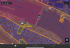
As has been said before it depends on how good your eyes are. Anyway some examples on the river thames . 1223 m . Surprisingly or not when I turned the drone sideways for the tower of london shot I lost one bar on the reception. My guess would be in the open about 1.5km . With tall buildings much less
Attachments
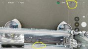
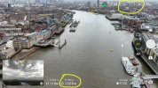
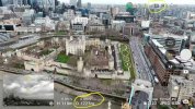
Pretty sure that is a no fly zone as well as being the helicopter flight path for central London.As has been said before it depends on how good your eyes are. Anyway some examples on the river thames . 1223 m . Surprisingly or not when I turned the drone sideways for the tower of london shot I lost one bar on the reception. My guess would be in the open about 1.5km . With tall buildings much less
Droning on and on...
Well-Known Member
Pretty sure that is a no fly zone as well as being the helicopter flight path for central London.
If so, how did the drone fly? Was it hacked?
Curious.
If so, how did the drone fly? Was it hacked?
To be fair I did not consider whether you had submitted a request to ATC to fly And got permission. Obviously the drone does not need to be hacked for the operator to fly it in a no fly zone, that would be for the operator to identify not the drone.If so, how did the drone fly? Was it hacked?
Curious.
Attachments
Similar threads
- Replies
- 47
- Views
- 4K
- Replies
- 5
- Views
- 1K
- Replies
- 1
- Views
- 4K
- Replies
- 1
- Views
- 694
- Replies
- 18
- Views
- 6K


DJI Drone Deals
New Threads
-
 2 Pro Wet spring/summer now it's turning hot/muggy for the rest of the summer....
- Started by MavicFlyer2
- Replies: 0
-
-

-
 Mavic 3 Thermal - Brand New - Sealed - 2 yr Care-Refresh
- Started by Dave Pitman
- Replies: 0
-
 3 Mavic 4 Pro Up Around Mount Baker
- Started by MikeReidPhotography
- Replies: 2
Members online
Total: 1,511 (members: 16, guests: 1,495)
Forum statistics
