DJI Mavic, Air and Mini Drones
Friendly, Helpful & Knowledgeable Community
Join Us Now

What more do you need from a recreation drone?

LiDar, as I understand it, is able to see THROUGH obstacles. I don't know how that would help someone land or even navigate while flying. I'd like to hear how it would help.
I'm not sure LiDAR is ONLY useful for seeing through objects. Did you read that somewhere on DJI's website?

DJI doesn't explain this in their manual, but here are some benefits of LiDAR sensors in general:
  1. Real-time 3D Mapping: LiDAR sensors emit laser beams and measure the time it takes for the light to return after hitting an object. This allows the drone to create a real-time 3D map of its surroundings, making it easier to detect obstacles like trees, buildings, or people.

  2. High Precision: LiDAR offers very precise measurements, often to within a few centimeters. This helps the drone navigate complex environments with better accuracy than other sensors like cameras or sonar.

  3. Works in Various Lighting Conditions: Unlike cameras, which can be affected by poor lighting or glare, LiDAR works equally well in bright light, low light, and even complete darkness. This ensures the drone can detect obstacles in a wide range of environments.

  4. Improved Collision Avoidance: By detecting obstacles well in advance, the forward-facing LiDAR sensor enables the drone to calculate alternative flight paths or stop to avoid a collision.

  5. Enhanced Autonomy: With a forward-facing LiDAR sensor, the drone can more reliably perform autonomous missions, especially in unfamiliar or dynamic environments, without requiring constant human intervention.
 
  • Like
Reactions: Erk1024
LiDar, as I understand it, is able to see THROUGH obstacles

Lidar is "light detection and ranging". It sends our a pulse of light, and then times how long it takes to return (yes at the speed of light). From that, it knows the depth of obstacles, and over time it can build up a 3D map. One problem with Lidar is that it doesn't work on dark or reflective objects (glass, mirrors, etc.) because those objects don't reflect the Lidar photons back to the sensor.

Lidar is often used in conjunction with SLAM (Simultaneous Localization And Mapping) where it figures out where the device is, and at the same time maps it's environment. The Augmented Reality headsets do this (e.g. Apple Vision Pro, Quest 3, etc.)
 
  • Like
Reactions: msinger
I'm not sure LiDAR is ONLY useful for seeing through objects. Did you read that somewhere on DJI's website?

DJI doesn't explain this in their manual, but here are some benefits of LiDAR sensors in general:
  1. Real-time 3D Mapping: LiDAR sensors emit laser beams and measure the time it takes for the light to return after hitting an object. This allows the drone to create a real-time 3D map of its surroundings, making it easier to detect obstacles like trees, buildings, or people.

  2. High Precision: LiDAR offers very precise measurements, often to within a few centimeters. This helps the drone navigate complex environments with better accuracy than other sensors like cameras or sonar.

  3. Works in Various Lighting Conditions: Unlike cameras, which can be affected by poor lighting or glare, LiDAR works equally well in bright light, low light, and even complete darkness. This ensures the drone can detect obstacles in a wide range of environments.

  4. Improved Collision Avoidance: By detecting obstacles well in advance, the forward-facing LiDAR sensor enables the drone to calculate alternative flight paths or stop to avoid a collision.

  5. Enhanced Autonomy: With a forward-facing LiDAR sensor, the drone can more reliably perform autonomous missions, especially in unfamiliar or dynamic environments, without requiring constant human intervention.
I didn't read about LiDar in a DJI manual. I am going on basic knowledge of LiDar in general.
So, better obstacle avoidance? I suppose that's a benefit.
 
So, better obstacle avoidance? I suppose that's a benefit.
Indeed. Any type of flyer could benefit from better obstacle avoidance.
 
It's interesting how much crossover there is between VR headsets and DJI drones. But it makes sense when you think about it, they are trying to solve some of the same problems.

Hovering in a spot is difficult (heck hovering at all in an FPV drone is very hard). I'm pretty sure this is how the DJI drones do it because this is how it's done in other applications:

* GPS - this gives reasonably accurate locations, within a few meters, but it's not accurate enough to hover in one spot. The elevation calculation is extra inaccurate.
* The logic board has IMU's (Inertial Measurement Unit) and Gyroscopes to figure out if the drone is moving around (because of it's own forces, or because of wind).
* But IMU's and gyros experience drift over time. So the drone uses cameras. If the images in the cameras start to move or rotate, then the drone knows it's moving. This is called "inside out tracking".

All this data is combined in a process called "sensor fusion". Basically it takes all this data and tries to figure out if it's moving so it can adjust. And it does this many times per second.

Finding obstacles is done by the cameras by matching up two images and determining the amount of parallax. Hold your finger about four inches from your face. Open one eye, close it and open the other eye. It looks like your finger moves. However something across the room doesn't appear to move at all.

So by adding Lidar, they are adding another powerful sensor to the mix. Lidar is nice because it can detect obstacles DIRECTLY instead of indirectly using parallax. And even better. Lidar is more effective (more likely to reflect light off the object) the closer you get to it. So, it's pretty good for obstacle avoidance.

If you detect something in the Lidar, and you know your position, then you can save the position of the obstacle in 3D space. Then if you "remember" that obstacle, you can avoid it at some point in the future.

Lidar is not perfect though. Sometimes you get phantom readings from it. But the Lidar data gets read a few times a second, so by averaging the results, they get more accurate.

Hope this helps.

These drones are amazingly sophisticated.
 
Last edited:
I love RTH. It just needs a lot more work to get closer to perfect. If we have RTH in 5 years the same as we have today, I'm going to be really disappointed. I will love it even better when I can breathe a sigh a relief instead of crossing my fingers.
 
  • Like
Reactions: Rchawks and Erk1024
I have used RTH many times as my drone is small and my eyesight not what it used to be, I often lose sight of it when I glance at my screen then look back at the drone, I do take over once I can see the drone again I have never had a problem with RTH.
 
  • Like
Reactions: MARK (LI)
I don't understand the dislike for the RTH.
The RTH, as I understand it, relies on GPS. The drone would head to a certain height (variable in the remote menu, that programs into the drone) and then heads to GPS coordinates, then proceeds to do a vertical landing. So as long as the area directly above the home set point, the drone can land safely.

LiDar, as I understand it, is able to see THROUGH obstacles. I don't know how that would help someone land or even navigate while flying. I'd like to hear how it would help.

There also seems to be some dislike for the obstacle avoidance. I think it's good. I've crashed into trees but, that was in a drone that wouldn't stop in one spot when the controls were released. Yeah. it was a cheap drone. I have a handful of them.

I got lucky with a RC plane. As I've mentioned, I get the directions mixed up when flying towards me. Once I was in a forest clearing and took off. When I was bringing the plane back I swapped the sticks and took the plane right into the trees. The people in the picnic area said I was zooming all around the trees (trying to gauge where it was by the sound) and missed every tree. I made a dozen turns in that forest and have no idea how I didn't crash it but that's why "I" need obstacle avoidance.

For reference, the pic below is where I was flying that plane.

View attachment 178516
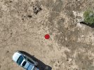
Preceison landing relies both upon GPS and visual cues. Upon takefoff, the downward optical sensors on the bottom of the craft identify the features of the home point, assuming you ascend straight up to twenty feet or so to let them do their thing and you get an audible "homepoint updated" notification. GPS also notes the location of the homepoint. When you activate RTH, GPS flies the drone back to the general vicinity of the homepoint, its accuracy compromised a bit by errors in drift due to the repositioning of satellites during the drone's flight. Once GPS has guided the drone back to within a few feet, laterally, of the homepoint, and the landing procedure has commenced, the camera pivots downward to precisely locate and home in on the terrain features which were identified by the downward sensors at takeoff. At least that how it works with the latest update on my Air 3. I use a Hoodman landing pad, which is quite conspicuous when viewed from aloft, so it's easy for the camera(s) on the drone to get an accurate fix on it both when taking off and again when landing. It would be pretty hard for the camera to miss that bright reddish-orange circle. My RTH landings are always within inches of the takeoff spot, with the craft also oriented at the same azimuth (yaw) as when it took off.

Because the LiDAR sensor on the new Air 3S is forward looking, I doubt it plays any role in landing. Its primary value is in being able to detect obstacles earlier and at a greater distance than the optical/visual sensors during low-light conditions.

The attached shot was taken with the 24mm camera during a RTH landing sequence.

DJI_20241014135000_0033_D (Custom).JPG
 
  • Like
Reactions: Erk1024
LiDar is cool but where would a recreational flyer need it? I'm not being rude, I'm actually curious if there's a reason?

You have WAY to much faith in the successful operation of OA on the Mini 4P (and every other DJI drone before the Air 3S).

You ask what could be improved? Obstacle Avoidance. And it's not just a firmware change. As the 3S demonstrates, new hardware (lidar) is necessary to take it to the next level.

Current OA is unreliable enough not to rely on it. The improvements in the A3S with the new lidar system may be improved enough to actually trust it.

DJI seems to, with the changes to RTH.
 
  • Like
Reactions: MARK (LI)
I don't understand the dislike for the RTH.

Everyone loves it for emergency situations, like loss of signal, remote failure, etc. You get your drone back.

As for manual, deliberate triggering to simply return, some prefer to fly back themselves, some think it a bad idea because skills may get rusty.

I've been flying DJI drones for 10 years, starting with a Phantom 4. I've logged over 1000 hours. Flying back is like watching paint dry, boring as...

I don't need practice holding the pitch stick forward for a long stretch. I use RTH almost every flight, exception being FPV. I do, however, cancel when its about 50 feet above the HP and finish the landing manually. Because I like to.

LiDar, as I understand it, is able to see THROUGH obstacles. I don't know how that would help someone land or even navigate while flying. I'd like to hear how it would help.

Nope, none of that. Lidar simply has greater range and resolution than the OA cameras, and works in the dark.

So, with lidar OA can work in low light (new), and has suffient resolution that DJI can now navigate back along it's outbound path visually, accurately enough it can return to the HP without GPS. The 3S builds a 3D map during flight, and then uses this to plan a flight path for RTH.

It's essentially similar to terrain-following-radar, although far less sophisticated.
 
Last edited:
as many of us forum members ,myself included ,have stated over many years of experiencing the advancement of OA it is far from foolproof,and you still need to be mindfull that there are times when it will not prevent your drone from an early demise
and its important that you always before any flight ,go into the settings and check that if applicable the OA is activated and that you have a clear area away from obstacles to take off and land ,in the event of any sort of RTH scenario,that you yourself may have triggered, or the drone had decided to RTH due to one of its built in RTH actions also check those out in your preflight checks
 
I didn't read about LiDar in a DJI manual. I am going on basic knowledge of LiDar in general.

Then why don't you seem to know that it's main function is ranging, not penetrating objects?

Whether the outbound pulse reflects from the surface depends on the light frequency. Ranging applications typically use a red laser, as is the case on the A3S.
 
  • Like
Reactions: MARK (LI)
It's interesting how much crossover there is between VR headsets and DJI drones. But it makes sense when you think about it, they are trying to solve some of the same problems.

Hovering in a spot is difficult (heck hovering at all in an FPV drone is very hard). I'm pretty sure this is how the DJI drones do it because this is how it's done in other applications:

* GPS - this gives reasonably accurate locations, within a few meters, but it's not accurate enough to hover in one spot. The elevation calculation is extra inaccurate.

VPS is used for positioning below 10-15m, whether there is a GPS lock or not. Above that, GPS provides sensing movement relative to the ground. In fact, you can fly the drone without GPS with full positioning behavior if there is sufficient light for VPS to function... This is called OPTI mode.
 
Last edited:
  • Like
Reactions: Cafguy and Erk1024
The Mavic 3 Cine does everything I require and then some, is there room for improvement, sure there is, but why mess with a good thing.
 
Preceison landing relies both upon GPS and visual cues. Upon takefoff, the downward optical sensors on the bottom of the craft identify the features of the home point, assuming you ascend straight up to twenty feet or so to let them do their thing and you get an audible "homepoint updated"

A few corrections... The HP is strictly a GPS coordinate. The "homepoint updated" message has nothing to do with Precision Landing. All DJI drones give this message on takeoff when there is a GPS lock, whether they have the PL feature or not.

PL works by capturing an image with the downward VPS cameras, and then using that image in the optical flow algorithm to match it using the same VPS cameras. The main camera plays no role in PL.

notification. GPS also notes the location of the homepoint. When you activate RTH, GPS flies the drone back to the general vicinity of the homepoint,

Actually, it flies back to the exact lat/long stored as the HP. With typical GPS precision, it gets within a few feet of the actual takeoff point.

If the drone model has the PL feature, when reaching about 30-40 feet over the HP it will start maneuvering to match the VPS camera view to the image stored, usually landing within 2-3" of the takeoff spot.
 
Last edited:
What I would ask for---and I only fly reccreationally. I would like a premium transmitter. When I flew fixed wing RC models, I had upscale transmitters (JR and Multiplex--before Hitec bought them) that flew all of the birds---airplanes, helicopters, and gliders. You could program any of the buttons for any of the channels on the receiver. Therefore, the flap knob was the same place on all of the planes----the retract toggle, rates, etc....And it felt like a solid piece of equipment in my hands. I know I am in the BIG MINORITY here, but the FPV (game style) controller and the motion controllers smack of a toy. The RC with the screens are better, but I would like to see something with the screen size of a iPad mini with some kind of built in retractable sun screen, programable knobs so I could use the same knob for zoom and the same for camera tilt as I always seem to have it backwards.It would also control ALL of the drones and you would just switch from one model to another.
 
A few corrections... The HP is strictly a GPS coordinate. The "homepoint updated" message has nothing to do with Precision Landing. All DJI drones give this message on takeoff when there is a GPS lock, whether they have the PL feature or not.

PL works by capturing an image with the downward VPS cameras, and then using that image in the optical flow algorithm to match it using the same VPS cameras. The main camera plays no role in PL.


Actually, it flies back to the exact lat/long stored as the HP. With typical GPS precision, it gets within a few feet of the actual takeoff point.

If the drone model has the PL feature, when reaching about 30-40 feet it will start maneuvering to match the VPS camera view to the image stored, usually landing within 2-3" of the takeoff spot.
In essence, you agree with and restate the content of my post, except as regards the main camera's role during the RTH landing sequence.

Yes, GPS guides the craft back to a close approximation of its launch point. But on my Air 3, whose firmware was updated about two weeks ago, the main camera then automatically pivots downward and locks into a vertical position at the start of the RTH landing sequence (at my chosen RTH return altitude of 120' above the home point), and a small drone-shaped symbol is projected on the camera's image of the home point (in my case, a conspicuous Hoodman pad) on the controller display. Then, four or five feet above the ground, the main camera pivots back to its horizontal position and the downward VPS cameras apparently take over.

How would you explain the main camera's behavior in that manner if it plays no role in precision landing? It didn't start doing that until after my recent update.

I'm well aware of how GPS operates and of its accuracy. I use GPS regularly to document the location and arial extent of archaeological sites, but I don't use lat/long. I rely instead on the Universal Transverse Mercator projection system (UTM) because location coordinates are expressed directly in terms of distance (in meters) north or south of the Equator and in meters east or west of established baselines in each zone and band. UTM is more intuitive and way more useful than lat/long, and it makes it a lot easier to plot locations of sites on maps and to calculate the distance between sites using scale overlays, though most mapping softwares now do that automatically. The problem with lat/long is that a degree of longitude at the equator subtends a much larger distance than a degree of longitude at higher latitudes, since lines of longitude gradually converge toward the poles. Thus, elements of the lat/long grid are increasingly trapezoidal at higher latitudes. Elements of the UTM grid are rectangular regardless of latitude. Another problem with lat/long is that it can be expressed in a variety of ways, such as degrees, minutes and seconds or in decimal degrees, or in degrees and decimal minutes, and so on -- something like "You say tomayto and I say tomahto."
With UTMs, everyone uses the same notational language.

Lat/long may be satisfactory for ordinary folks who occasionally note or reference locations on their cell phones. It isn't used much by folks who do serious location work. The National Park Service, with which I share my findings, doesn't even reference lat/long in the margins of its work maps anymore.

If you have and use a hand-held GPS receiver, you can go into settings and change location readouts from lat/long into UTMs, or you may be able to display readouts of both so you don't need to toggle back and forth from one system to the other. The only time I use lat/long is when someone alerts me to the presence of a potential site they've discovered and located using lat/long on their phones. Then I convert it to UTMs.
 
  • Like
Reactions: Erk1024
A few corrections... The HP is strictly a GPS coordinate. The "homepoint updated" message has nothing to do with Precision Landing. All DJI drones give this message on takeoff when there is a GPS lock, whether they have the PL feature or not.

PL works by capturing an image with the downward VPS cameras, and then using that image in the optical flow algorithm to match it using the same VPS cameras. The main camera plays no role in PL.


Actually, it flies back to the exact lat/long stored as the HP. With typical GPS precision, it gets within a few feet of the actual takeoff point.

If the drone model has the PL feature, when reaching about 30-40 feet it will start maneuvering to match the VPS camera view to the image stored, usually landing within 2-3" of the takeoff spot.
It's crazy how good precision landing is and it sounds so simple.
 
I don't need practice holding the pitch stick forward for a long stretch. I use RTH almost every flight, exception being FPV. I do, however, cancel when its about 50 feet above the HP and finish the landing manually. Because I like to.
This is what I do and I have never had a problem getting the drone back.
 

DJI Drone Deals

New Threads

Members online

Forum statistics

Threads
135,089
Messages
1,602,311
Members
163,575
Latest member
foooz
Want to Remove this Ad? Simply login or create a free account