DJI Mavic, Air and Mini Drones
Friendly, Helpful & Knowledgeable Community
Join Us Now

Search and Rescue

Glenh

Well-Known Member
Premium Pilot
Joined
May 20, 2022
Messages
118
Reactions
100
Age
70
Location
CROWS NEST, 2065
I have been requested to assist in a search and rescue operation - tomorrow morning.

This with a Mini 2.

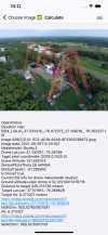
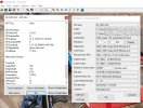
My question - if I observed something of interest is there a way that I can record the coordinates (with a Mini 2) ?

Following that, the only way to communicate this would be to exit the fly app and make a call/text message on my phone while the drone hovers, and then seamlessly re-connect the RC with the Drone. Scary.

Has anyone tried something similar?
 
Screenshot your device to capture the coordinates and the view of the camera.
Depending on the app you are using to fly, you could mark the spot with a waypoint.
Your observer could make a call while you monitor your drone.
 
Screenshot your device to capture the coordinates and the view of the camera.
Depending on the app you are using to fly, you could mark the spot with a waypoint.
Your observer could make a call while you monitor your drone.
Good points, thank you
 
  • Like
Reactions: mak$$
You could go old-school....
Is the search area already planned out? If it is: print off a google earth map of the location. Work out where your TOAL point will be and mark it on the map. Study the image to determine any conspicuous landscape features - mark them (e.g: L1... L2 etc.). Divide the rest of the map into a grid and mark each square with a grid number or letter. Search each grid square systematically and in order. If you log the centre point of each square (bottom right-hand corner of the Google map) you already have a northing and westing GPS datum-point that you can aim a ground search towards. This will be accurate to WGS84 standard.

For example: this is a gridmarked aerial map printed before using a mavic 2 to search for the remains of a lost 12th century structure in 2019. It took me less than half an hour to create.
search.jpg
 
Last edited:
Hi @Glenh,

Our firm maintains free and open source software called OpenAthena, which allows precise ground coordinates to be instantly calculated from any point in a drone image. The app uses metadata present in drone images with a digital elevation model to calculate ground location using terrain-raycasting.

We have both an Android and iOS versions of the app. The iOS version supports automated download of Digital Elevation Models, while the Android version currently requires one to be loaded manually:
tap_to_locate_demo_small.gifoa-2.0-Simulator_Screenshot-iPhone_12_Pro_Max-2023-11-17_at_10.08.44.pngoa-2.0-Simulator_Screenshot-iPhone_12_Pro_Max-2023-11-17_at_10.12.36.pngoa-2.0-Simulator_Screenshot-iPhone_8_Plus_iOS_14.0-2023-11-17_at_09.40.48.png

Unfortunately, the Mavic Mini 2 does not seem to be compatible with this app as its images do not contain sufficient metadata necessary for calculation. This was determined in testing last December, firmware updates may have changed this but it seems unlikely. If you have recent images from your drone, please send them to [email protected] and we can analyze them for presence of the necessary metadata.

We've had good results with the Mavic Zoom 2 and Mini 3 Pro models for use with this app.

Please let us know if you have any questions

UAS Geodesy
 

Attachments

  • oa-2.0-Simulator_Screenshot-iPhone_12_Pro_Max-2023-11-17_at_10.12.28.png
    oa-2.0-Simulator_Screenshot-iPhone_12_Pro_Max-2023-11-17_at_10.12.28.png
    3.4 MB · Views: 8
  • oa-2.0-Simulator_Screenshot-iPhone_12_Pro_Max-2023-11-17_at_10.12.28.png
    oa-2.0-Simulator_Screenshot-iPhone_12_Pro_Max-2023-11-17_at_10.12.28.png
    3.4 MB · Views: 5
You could go old-school....
Is the search area already planned out? If it is: print off a google earth map of the location. Work out where your TOAL point will be and mark it on the map. Study the image to determine any conspicuous landscape features - mark them (e.g: L1... L2 etc.). Divide the rest of the map into a grid and mark each square with a grid number or letter. Search each grid square systematically and in order. If you log the centre point of each square (bottom right-hand corner of the Google map) you already have a northing and westing GPS datum-point that you can aim a ground search towards. This will be accurate to WGS84 standard.

For example: this is a gridmarked aerial map printed before using a mavic 2 to search for the remains of a lost 12th century structure in 2019. It took me less than half an hour to create.
View attachment 170374
A good idea. Thank you
 
Hi @Glenh,

Our firm maintains free and open source software called OpenAthena, which allows precise ground coordinates to be instantly calculated from any point in a drone image. The app uses metadata present in drone images with a digital elevation model to calculate ground location using terrain-raycasting.

We have both an Android and iOS versions of the app. The iOS version supports automated download of Digital Elevation Models, while the Android version currently requires one to be loaded manually:
View attachment 170378View attachment 170379View attachment 170382View attachment 170383

Unfortunately, the Mavic Mini 2 does not seem to be compatible with this app as its images do not contain sufficient metadata necessary for calculation. This was determined in testing last December, firmware updates may have changed this but it seems unlikely. If you have recent images from your drone, please send them to [email protected] and we can analyze them for presence of the necessary metadata.

We've had good results with the Mavic Zoom 2 and Mini 3 Pro models for use with this app.

Please let us know if you have any questions

UAS Geodesy
Great software. I will send you a jpeg for your comment
 
Take a photo with the drone. Then you can look up the exif of the photo for the GPS coordinates.
 

Attachments

  • exif.jpg
    exif.jpg
    139.6 KB · Views: 16
Where are you conducting SAR operations and who are you reporting to?
And who has requested your assistance?
 
Can I do 'Find my drone'while hovering, and then go back to normal flight mode?
Yes you can (you go back to fly) otherwise not interesting for you..

Look at this video from #Hatu in Spanish:
 
If you use a device with a larger screen, it will be better for this application. It’ll also free up your phone. But in any event, It’s simple, if using an Apple device, descend as far as safely possible with your crosshairs at 90 degrees down and take a screenshot. Then tap the “i” circled near the top right. Then scroll down and tap the general location at the bottom left. It will give you the exact coordinates. Please make sure you have permission to participate from the INCIDENT COMMANDER or you could find yourself in a lot of trouble.IMG_1482.png
IMG_1483.png
IMG_1481.png
 
Last edited:
Hi @Glenh,

Our firm maintains free and open source software called OpenAthena, which allows precise ground coordinates to be instantly calculated from any point in a drone image. The app uses metadata present in drone images with a digital elevation model to calculate ground location using terrain-raycasting.

We have both an Android and iOS versions of the app. The iOS version supports automated download of Digital Elevation Models, while the Android version currently requires one to be loaded manually:
View attachment 170378View attachment 170379View attachment 170382View attachment 170383

Unfortunately, the Mavic Mini 2 does not seem to be compatible with this app as its images do not contain sufficient metadata necessary for calculation. This was determined in testing last December, firmware updates may have changed this but it seems unlikely. If you have recent images from your drone, please send them to [email protected] and we can analyze them for presence of the necessary metadata.

We've had good results with the Mavic Zoom 2 and Mini 3 Pro models for use with this app.

Please let us know if you have any questions

UAS Geodesy
That’s pretty cool tbh.
 
  • Like
Reactions: Theta
Where are you conducting SAR operations and who are you reporting to?
And who has requested your assistance?

If you use a device with a larger screen, it will be better for this application. It’ll also free up your phone. But in any event, It’s simple, if using an Apple device, descend as far as safely possible with your crosshairs at 90 degrees down and take a screenshot. Then tap the “i” circled near the top right. Then scroll down and tap the general location at the bottom left. It will give you the exact coordinates. Please make sure you have permission to participate from the INCIDENT COMMANDER or you could find yourself in a lot of trouble.View attachment 170434
View attachment 170435
View attachment 170438
Good thinking! Thanks for that. I can then take a screenshot of this showing the coordinates and sms/email to command and control?

Rest assured, the team (including Drone Surveillance) is being coordinated by the Incident Commander (Regional Law Enforcement Officer).
 
  • Like
Reactions: Dbez1
Where are you conducting SAR operations and who are you reporting to?
And who has requested your assistance?
Your questions are slightly off of the topic of this thread but thank you for your interest and tacit offer of assistance, I assume.

The original request came from the mother of the missing person. Rest assured, the SAR team (including Drone Surveillance) is being coordinated by the Incident Commander (Regional Law Enforcement Officer).

I am not qualified to elaborate on this and I suggest that it is more appropriate to discuss the interesting topic of Government procedures and/including Drone Uptake on a separate forum.
 
  • Like
Reactions: MotoSavy
Lycus Tech Mavic Air 3 Case

DJI Drone Deals

New Threads

Forum statistics

Threads
131,133
Messages
1,560,156
Members
160,105
Latest member
anton13