DJI Mavic, Air and Mini Drones
Friendly, Helpful & Knowledgeable Community
Join Us Now

Sedona Arizona drone flight... recreational

All right gentlemen, let's see if I can clear the mud about class E airspace....

I think the confusion lay in the fact that sometimes, class E airspace starts at 700 feet, or 1200 feet or 12,500 feet!

But wait! There is more!

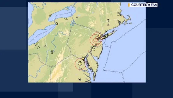
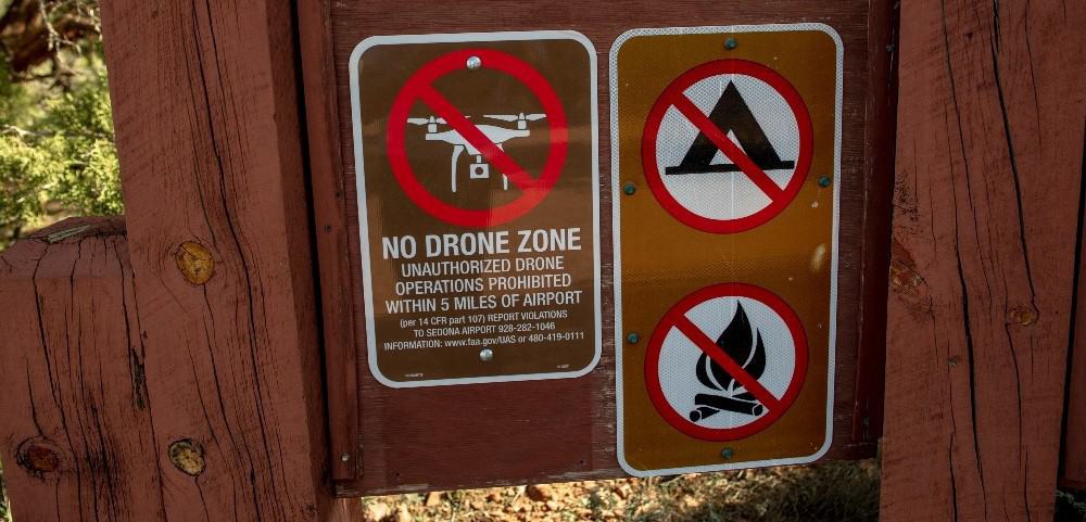
Sometimes, class E airspace extends all the way down to the surface of the airport... In this case, yes, a hobby flyer would need prior authorization . ( see pic of Watertown regional airport in South Dakota)

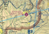
In Sedona's case, Class E starts at 700'. The fact that the airport is in magenta, means that it is un-towered. See how it is surrounded by a magenta area? It means Class G starts at the surface, and goes to 699'. Class E starts at 700', all the way to 18,000' where it becomes class A and completely irrelevant to a drone pilot.

The AC listed below is only talking about theses airports that have classe E all the way to the ground, hence the "Within the lateral boundaries of the SURFACE area of class E"

How do I know when the airport is a class E all the way to the ground?
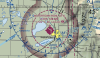
It looks a lot like Class D airspace, but with a magenta border instead of blue. (see example)


Source:
 

Attachments

  • Screen Shot 2019-06-07 at 11.33.02 PM.png
    Screen Shot 2019-06-07 at 11.33.02 PM.png
    2.6 MB · Views: 30
  • Screen Shot 2019-06-07 at 11.41.14 PM.png
    Screen Shot 2019-06-07 at 11.41.14 PM.png
    749.9 KB · Views: 28
Last edited:
  • Like
Reactions: Thomas B and AMann
The way the advisory is written, that doesn’t matter. It implies that the distance laterally away from the airport where class E lies above the class G is restricted for recreational pilots unless they can get permission from the airport administration or the designee for the airport.
You're misinterpreting it. It says Within the Lateral Boundaries of the Surface Area of Class E Airspace Designated for an Airport The Class E denoted by the shading isn't designated for an airport, it's for the airspace. If there is Class E designated for a particular airport, the airport has a magenta dashed line around the airport (Class E2) the magenta shaded airspace is Class E5. This is from the Phoenix Sectional on which the Sedona airport is shown. Note the first entry.
74817

Do a Google search on "lateral boundaries of the surface area"
 
  • Like
Reactions: Thomas B and AMann
You're misinterpreting it. It says Within the Lateral Boundaries of the Surface Area of Class E Airspace Designated for an Airport The Class E denoted by the shading isn't designated for an airport, it's for the airspace. If there is Class E designated for a particular airport, the airport has a magenta dashed line around the airport (Class E2) the magenta shaded airspace is Class E5. This is from the Phoenix Sectional on which the Sedona airport is shown. Note the first entry.
View attachment 74817

Do a Google search on "lateral boundaries of the surface area"

OK that’s more reasonable, I am sorry I caused confusion on that. There’s a pretty big loophole regarding this as Class G lying under the Class E at the uncontrolled airport in Sedona would be seen as flyable, even near it if someone wanted to push that point.

0FA8E835-4CB2-4736-980F-56696712E334.jpeg
 
  • Like
Reactions: Thomas B
Flying in Sedona, because it is a class G IS flyable. That's not a loophole.

However... The wilderness areas are out. (Basically the mountains in the NW and NE.) They actually always have been, including for manned aircraft. (They are required to be at least 2000' AGL above the highest elevation within 8 miles)

However... The level of traffic on week-ends during sightseeing rides, and the current airport manager frowning upon UAS flights, may require a better judgment.
 
  • Like
Reactions: Thomas B
Confusing, right? This is from the FAA Aeronautical Information Manual, section 3-2-6 on Class E Airspace
NOTE−
Do not confuse the 700-foot and 1200-foot Class E transition areas with surface areas or surface area extensions.

To add more confusion, this question and answer are on the FAA's Unmanned AIrcraft Systems "Webinar Frequently Asked Questions" (current as of May 9, 2019)
Q: How close to a local civil airport can I fly below 400'?
A: Assuming we are talking about flights conducted under Part 107, the answer depends on what airspace that airport lies within.
If the airport is in Class G airspace, you can fly anywhere within that airspace, under 400 feet and within visual line-of-sight. You must not interfere with manned traffic or create a collision hazard. If you are in controlled airspace, you need to obtain an airspace authorization via LAANC or DroneZone before you fly.

Followed by

Q: Where can I find more information about Class E airspace?
A: See the Aeronautical Information Handbook, Chapter 3 for more information about airspace.
 
  • Like
Reactions: AMann
From the Sedona airport manager's report in the January 9, 2019 minutes of the Sedona airport board
74819
That was January, I wonder if the FSDO has given a presentation yet, given that information is still in flux.
 
  • Like
Reactions: AMann
Flying in Sedona, because it is a class G IS flyable. That's not a loophole.

However... The wilderness areas are out. (Basically the mountains in the NW and NE.) They actually always have been, including for manned aircraft. (They are required to be at least 2000' AGL above the highest elevation within 8 miles)

However... The level of traffic on week-ends during sightseeing rides, and the current airport manager frowning upon UAS flights, may require a better judgment.

I agree about using common sense when flying nearby an airport that is in G class airspace, but based on some of the things I’ve seen here and on YouTube, does such a thing as “better judgment” truly exist for all those wishing to fly in beautiful places like Sedona? No, I think it’s a loophole that the FAA has not addressed yet. Did they really intend to allow people to fly as recreational pilots, and not 107 certificated pilots, next to the airport without informing anyone ahead of time?
 
  • Like
Reactions: Thomas B
I agree about using common sense when flying nearby an airport that is in G class airspace, but based on some of the things I’ve seen here and on YouTube, does such a thing as “better judgment” truly exist for all those wishing to fly in beautiful places like Sedona? No, I think it’s a loophole that the FAA has not addressed yet. Did they really intend to allow people to fly as recreational pilots, and not 107 certificated pilots, next to the airport without informing anyone ahead of time?

One point. Sedona airport sits atop a mesa. You could fly a drone all around the actual town of Sedona and never get close to the airport surface even at 400' AGL. So, in this instance, there really isn't much to worry about in regards to interfering with manned aircraft.
 
So I'm a bit confused on the status of flying a drone in the general area. For anyone not familiar, Sedona is obviously an epic place for scenery, but there's an airport more or less smack in the middle of the place. A very large portion of the trail systems in the area fall within a 5 mile radius of the Sedona airport.

So based on that 5 mile radius alone, and what I recall reading recently, it would sound like as a non-107 pilot, I'm SOL?

But then there's this article (admittedly, pre-dating the May rule changes.)

Meanwhile, the DJI flight map shows no restrictions or anything around Sedona. Same with Airmap (although that at least also indicates the wilderness boundaries around there which I'd be avoiding.)

So yeah, anyone with a bit more knowledge on the rules/area than me able to chime in? I'd REALLY like to get some footage during some mountain bike riding, but i'm not looking to anger the FAA in the process.

Looking to ride/operate drone in the general area circled in blue below. Airport a bit to the north (and located on a higher elevation/mesa.) Would be looking at pretty low fliying as well.

My brother resides in Sedona and I will tell you that many residents and visitors will be upset with the sound of your buzzing drone disturbing a natural area. People go there to immerse in nature. In addition, there are many raptors (birds) that won't take kindly to your drone as well.

You will find signs placed by the USFS it's a "no drone zone". However, it's not enforceable according to the news article linked below. Just be aware you're going to piss a lot of people off and give our hobby a bad name.

Sedons's 'No Drone Zone' signs unenforceable
DroneWeb.jpg
 
The city of Sedona is in class G airspace. Class E airspace around the airport begins at 700 feet above the surface, and class G airspace their begins at 699 feet above the ground.

This is the real deal and I'm flying my Mavic 2 Pro in Sedona on Tuesday! So there!!! LOL :)
 
Class E airspace around the airport begins at 700 feet above the surface, and class G airspace their begins at 699 feet

You mean class G starts on the ground, up to 699’, with class E starting above it at 700’.
 
My brother resides in Sedona and I will tell you that many residents and visitors will be upset with the sound of your buzzing drone disturbing a natural area. People go there to immerse in nature. In addition, there are many raptors (birds) that won't take kindly to your drone as well.

You will find signs placed by the USFS it's a "no drone zone". However, it's not enforceable according to the news article linked below. Just be aware you're going to piss a lot of people off and give our hobby a bad name.

Sedons's 'No Drone Zone' signs unenforceable
DroneWeb.jpg
Just FYI those signs have nothing to do with the USFS. They were placed by people connected to the airport. They were made to look like USFS signs to make people think they have some federal authority behind them. However, as the article you linked to states, they are unenforceable, illegal and basically completely bogus. Neither the city nor the airport has any authority over the airspace and it is all class G. They even try to claim authority over lands that they have none over.

Flying in Sedona is terrific and I've done it several times. Just watch out for low flying tourist flights and be courteous to other people. Fly up quickly so noise becomes a non-issue. You know... Be a responsible UAS operator like most of us are. The only person I've encountered in the Sedona area who had an issue with drone flights was a crotchety old Pink Jeep tour driver. Most are nice, he was not. In fact he was an ***, made several rude comments to his passengers about drones and those who fly them and deliberately held up his tour once he realized I was waiting until they left to fly (not even kidding). I never took the bait but eventually flew anyway and then he drove on.

Edit: regarding the USFS involvement: while the article mentions them briefly, they never note any actual USFS involvement and from what I've read elsewhere, they really weren't officially involved. At most, there might have been an employee acting on their own as a private citizen involved. It was all really done by the airport people.
 
Great pics to be had in Sedona for sure. As stated above. Fly up high quickly to abate noise and watch out for helicopter tours.
C08951F4-E2CA-44CC-80F9-BB73142C53A3.jpegD9BD9CF7-BE5E-4239-85F3-CB7676335E35.jpeg
 
  • Love
Reactions: dawgpilot
Scouring numerous maps/sources, Ill be damned if I could find any indication of that being controlled airspace, except finally one search (which made it look like basically every square inch of the country is controlled airspace, but i digress.)

Is there any source out there that's accessible and understandable to an airspace layman that is actually reliable? Had I just gone with the built-in DJI system/mapping and assumed it to be accurate, it would've happily let me take off in Sedona.

Oh the joys of trying to navigate government rules... Makes the three amateur radio/fcc tests I went through seem easy =)
At least with the FCC rules, they temporarily dropped the code requirement part of the exams. I doubt I would pass the 13 wpm code exam requirements reinstated for the General License today. Similarly, one would think the FAA would "grandfather" in licensed FAA Private Pilots (in lieu) of FAA Part 107 commercial drone license requirements. It would be akin to riding a bicycle versus a motorcycle. However, governments can't function without all their bureaucratic red tape.
 
  • Like
Reactions: mtb.arizona
Great pics to be had in Sedona for sure. As stated above. Fly up high quickly to abate noise and watch out for helicopter tours.
View attachment 79022View attachment 79023
Great pic. I forgot to mention, one should always check the METAR and NOTAMs from closest airport as part of your pre-flight planning. There may be a TFR in place. A couple of pilots discovered the hard way when F-16's intercepted them for violating a TFR.

 
  • Like
Reactions: dawgpilot
At least with the FCC rules, they temporarily dropped the code requirement part of the exams. I doubt I would pass the 13 wpm code exam requirements reinstated for the General License today. Similarly, one would think the FAA would "grandfather" in licensed FAA Private Pilots (in lieu) of FAA Part 107 commercial drone license requirements. It would be akin to riding a bicycle versus a motorcycle. However, governments can't function without all their bureaucratic red tape.

The FAA does make it much easier for a part 61 current pilot to get a Part 107 certificate. Instead of paying $150 and scheduling a test at a testing center, you can just take an short online course. Then you need a flight instructor or other authorized individual to verify your currency and upload that info into IACRA.

Unfortunately I wasn't current so I ended up having to pay the $150 instead. (which was probably cheaper than renting a plane for a couple hours to do a BFR with an instructor)
 
Lycus Tech Mavic Air 3 Case

DJI Drone Deals

New Threads

Forum statistics

Threads
131,187
Messages
1,560,743
Members
160,158
Latest member
JReynolds078