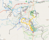
So I'm a bit confused on the status of flying a drone in the general area. For anyone not familiar, Sedona is obviously an epic place for scenery, but there's an airport more or less smack in the middle of the place. A very large portion of the trail systems in the area fall within a 5 mile radius of the Sedona airport.
So based on that 5 mile radius alone, and what I recall reading recently, it would sound like as a non-107 pilot, I'm SOL?
But then there's this article (admittedly, pre-dating the May rule changes.)
 www.redrocknews.com
Meanwhile, the DJI flight map shows no restrictions or anything around Sedona. Same with Airmap (although that at least also indicates the wilderness boundaries around there which I'd be avoiding.)
So yeah, anyone with a bit more knowledge on the rules/area than me able to chime in? I'd REALLY like to get some footage during some mountain bike riding, but i'm not looking to anger the FAA in the process.
Looking to ride/operate drone in the general area circled in blue below. Airport a bit to the north (and located on a higher elevation/mesa.) Would be looking at pretty low fliying as well.
So based on that 5 mile radius alone, and what I recall reading recently, it would sound like as a non-107 pilot, I'm SOL?
But then there's this article (admittedly, pre-dating the May rule changes.)
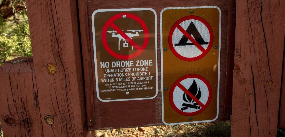
Sedona's 'No Drone Zone' signs don't obey FAA law, can't be enforced by USFS, Sedona Airport - Sedona Red Rock News
Drones are small remote-controlled flying machines often used by hobbyists for aerial photography, and reconnaissance in firefighting and law enforcement. Sedona has become a destination for recreational drone users due to the scenic geography. But drone enthusiasts have noticed the dozens of...
www.redrocknews.com
Meanwhile, the DJI flight map shows no restrictions or anything around Sedona. Same with Airmap (although that at least also indicates the wilderness boundaries around there which I'd be avoiding.)
So yeah, anyone with a bit more knowledge on the rules/area than me able to chime in? I'd REALLY like to get some footage during some mountain bike riding, but i'm not looking to anger the FAA in the process.
Looking to ride/operate drone in the general area circled in blue below. Airport a bit to the north (and located on a higher elevation/mesa.) Would be looking at pretty low fliying as well.