DJI Mavic, Air and Mini Drones
Friendly, Helpful & Knowledgeable Community
Join Us Now

Shooting spherical panoramas with the Mavic Mini 2

pgielen

Member
Joined
Jan 27, 2021
Messages
12
Reactions
4
Age
60
Location
Boxmeer
After having made many spherical panoramas with my DSLR on a heigth of 1.50m (and sometimes a bit higher), I wanted to get some experience with making aerial panoramas without having to do a drone exam first, so I tried this with a DJI Mavic Mini 2. The performance of the camera in this device is impressive for such a small (1/2.3") sensor. However, there seem to be a number of shortcomings in the software (DJI Fly) for making spherical panoramas:

1. The standard size of the photos is 2000x1500 pixels, while the camera is capable of taking photos of 4 times this size (4000×3000 pixels). The result is therefore less detailed than possible.

2. Instead of shooting DNG (raw) images, the camera only takes jpg images in panorama mode. That is a pity considering the greater post processing flexibility of raw files.

3. The EV is determined during the first shot and cannot be corrected manually. The result of this (in sunny weather) is often that the sky is well exposed while the ground remains underexposed, even if the first shot is directed away from the sun. The nadir comes out very, very dark, like this:
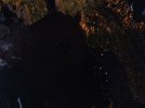
DJI_0005.JPG

For panoramas with high contrasts, exposure bracketing would be welcome. However, the software does not allow this in panorama mode. That is a pity.

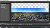
4. The controllable range of the gimbal is -90° to +20° when in extended mode, however the possibility for tilting upwards is not used when shooting a spherical panorama. As a result, the zenith hole is much bigger than necessary, as you can see when it is converted to cube-projection:
Cubes-problem.jpg

This makes it more difficult to edit the result. The only option left to make it fully spherical, is replacing the whole upper half of the panorama (in equirectangular projection) with a stock photo of the sky as I have done in this shot:
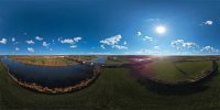
Bridge-Fake-Sky-Small.jpg
(Click here to see the interactive panorama)

In summary, the hardware of the Mavic Mini 2 is capable of so much more than the device's software allows when making spherical panoramas. This prevents the Mavic Mini 2 from optimum performance and that's a shame. Can anyone tell me if the Mavic Air 2 performs much better in panoramic mode, or does that use the same software? Is there an alternative to DJI Fly that is safe to use?

Pierre
 
Last edited:
  • Like
Reactions: Bruchpilot
I just turn the Mini 2 around manually, use the M camera mode, convert DNGs to 16-bit TIFFs and stitch them in PTGui Pro,
I guess you will have to turn the camera 60 degrees horizontal, and 20 degrees vertical for each panorama? Too bad the DJI software engineers missed the opportunity to add shooting a panorama in DNG and full size in the app.

BTW I use Kolor Autopano Giga for stitching which is versatile and easy to use. I still regret that GoPro has bought the Kolor company just for its patents and then killed it.
 
  • Like
Reactions: Metrocruiser
Hello,
Mini 2 and Air 2 both use DJI Fly.
While some points of your 1st post are valid, some are entirely false. Yes, JPGs saved to the card are smaller (1/4 of the sensor area), but you can set the drone to save also full sized DNGs to the card. Have you read a manual? Of course, DJI Fly app makes quite small panoramas (I'd call them "a preview") but you can make it much more detailed/bigger on your PC. Why they do that, why crippled version? I'm sure they are seriously concerned about the performance of mobile devices. I guess there is only very small % of users who have a device that is capable of making a 180Mpix 16-bit panorama "on the fly" in their memory while flying. If it is possible at all on a mobile device even in AD2021. Have you noticed that there is absolutely no 3rd party app on iOS/Android that can do it? Some 360 cameras stitch their dual fishe-eye cameras images but it's relatively easy to do it, but there is no app which makes spherical panoramas from 16-bit RAW files (Affinity Photo makes only horizontal panoramas). I use soft on my old PC and it definitely requires more then a blink of the eye to stitch all files and get 180Mpix pano.
Point #4 of your post is totally false. Definitely gimbal is tilted upwards +20deg. Watch your screen while pano is made + count "missing pixels" and you'll get 110deg vertically. To get easily missing sky you can use a couple of technics. I like the app called Skyfill - it usually makes quite good "estimates" of missing pixels.

Cheers
 
Last edited:
Of course, DJI Fly app makes quite small panoramas (I'd call them "a preview") but you can make it much more detailed/bigger on your PC.

How? The files saved on my SD card are only 2000x1500 pixels.

I'm sure they are seriously concerned about the performance of mobile devices.

The MM2 does not do any real time stitching and I don't care about that, I just want optimum quality in post processing.

Point #4 of your post is totally false. Definitely gimbal is tilted upwards +20deg. Watch you screen while pano is made + count "missing pixels" and you'll get 110deg vertically.

Maybe. I will try to verify that in my next flight. Point is, the zenith is still HUGE!

I like the app called Skyfill - it usually makes quite good "estimates" of missing pixels.

Thanks for the hint. I will try Skyfill. Hopefully it does a better job than 'Content aware fill' in Photoshop.
 
How? The files saved on my SD card are only 2000x1500 pixels.
TL;DR: RTFM.
Long version: read the manual first -> when you switch to the pano mode and go to the settings of DJI Fly app (3 dots) you can enable RAW (DNG) files. You'll get 16-bit DNG files and there is even a chance that you can recover underexp. pixels if you use eg. Adobe's RAW engine.
Maybe. I will try to verify that in my next flight. Point is, the zenith is still HUGE!
For on the ground panoramas it would be a disaster, but on 100m/ft AGL there is just a sky. And most of (small) drones cannot tilt much higher than 20deg. If you need more, MM2 was not the best choice. I can live with that 110deg since I'm more interested with the lower 90deg part. But that's me.
 
Last edited:
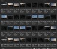
the mini 2 can save the 26 spherical pano images on the sd card as both dng and jpg. the dng files are 4000x3000 pixels. as i learned here from other threads, these can be stitched in MS ICE (image composite editor), Lightroom or Photoshop. each can do a great job. they also do some auto toning to help deal with exposure of highlights/shadows.

here is an adobe bridge browser view of one of my spherical pano folders...

sphr pano.jpg
 
  • Like
Reactions: Grazuncle
I use the Mav Air 2 to create Spherical panoramas. I don't know the details. I just put the setting to the max and let it do it's thing. It takes pics over the full range of the camera's angle capability up and down. I attached a Panorama of a driveway and house with blue skies and brick driveway, some palm trees. The image result is an 8000x4000 pixel image. I think it takes a series HDR photos, not sure. I use them for HDRI work in 3DS MAX and C4D.
 

Attachments

  • DJI_0808.JPG
    7.7 MB · Views: 46
Thank you all for pointing out my mistakes. I have succeeded in taking raw images with the MM2 in panorama mode at full resolution and with skyfill.exe an acceptable nadir can be made in most cases (not if you should see clouds in a blue sky).

What is remarkable is that the DNGs suffer from vignetting quite badly. The MM2 software apparently corrects the jpegs before it saves them, but if you use DNGs, they need to be corrected. In Autopano Giga there is a setting for this in the Settings > Panorama > Color Correction tab. Alternative, you could process all the DNG images in Adobe Camera Raw, with a vignetting correction setting of about +5.

vignetting.jpg
Image: vignetting is most notable in a clear blue sky.
 
congrats on making good progress.
i've not noticed such severe vignetting in the individual frames or the final stitch.
i'm using adobe lightroom or microsoft ice.
are you using a filter?
granted, there's usually something that needs editing afterwards, often on the horizon.
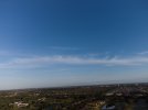
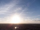
here are a couple images from earlier in march, with no processing, and the resulting stitch from lightroom.
by the way, i've no problems with scattered clouds...adds some interest, imho.

mar 13 2021 sphr 13 -0002 s.jpgmar 13 2021 sphr 13 -0020 s.jpgmar 13 2021 sphr 13 -0026-Pano s.jpg
 
I don't know where the vignetting comes from it is only visible in the DNG's and not in the JPEGS. I did not use a filter.
 
It is soooo simple...what soft, what bla bla....
To view this content we will need your consent to set third party cookies.
For more detailed information, see our cookies page.
 
  • Like
Reactions: Pawpaw Woody
Why is 4000x3000 pix jpgs not possible in panorama mode? I used that with my Mavic Air, now i "upgraded" to Mini2 and loss this function? (-yes, i know raw is better, but i dont want to work so much with the panos, jpgs was fine. -yes, i know i can do it manually, but hey! pano function is created by devs exactly to make this step easier..)
 
I guess you will have to turn the camera 60 degrees horizontal, and 20 degrees vertical for each panorama? Too bad the DJI software engineers missed the opportunity to add shooting a panorama in DNG and full size in the app.

BTW I use Kolor Autopano Giga for stitching which is versatile and easy to use. I still regret that GoPro has bought the Kolor company just for its patents and then killed it.
Yes, I use APG and PTP. I hate that go pro dumped it down the toilet. They killed the forum and all manuals.
 
I know this is an old thread but it has been useful; thanks all.

A bit of bad news: I have a Mini 2 SE and on that the DNG 'trick' is not possible -- it is greyed out in Pano mode. All you can get is the 2000x1500. Especially galling is that 2/3 of the resulting 3MP images are 'used up' in overlaps for stitching.
 
Lycus Tech Mavic Air 3 Case

DJI Drone Deals

New Threads

Forum statistics

Threads
134,442
Messages
1,594,815
Members
162,978
Latest member
dojin23