


- Joined
- May 14, 2018
- Messages
- 7
- Reactions
- 0
- Age
- 40
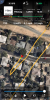
So I lost signal of my Drone with 30% battery. Windy day time of flight. I have last frame footage of drone . not sure if it fell from the sky or it hovered with the wind until it had to RTH at 25%. The coordinates show it is in the tree. I searched the tree but no luck as of yet .But I wanted to know what you guys think. Should I keep searching the tree or perhaps elsewhere? How accurate is Aircrafts missing coordinates? The video shows it flying 70ft above tree. It's been a sleepless 8 days hoping to recover drone before July.. Thanks in advance!


 .
.![2018-05-20_[17-02-30]_01.png](https://mavicpilots.com/data/attachments/39/39069-d589c5681fd0fd21ca77e89ac80fd915.jpg?hash=1YnFaB_Q_S "2018-05-20_[17-02-30]_01.png")


