DJI Mavic, Air and Mini Drones
Friendly, Helpful & Knowledgeable Community
Join Us Now

So confused about RTK

Laggard

Well-Known Member
Joined
Jan 31, 2021
Messages
105
Reactions
92
Age
58
Location
Los Angeles
So I took a mapping class and though I’m able to go out and map a piece of land, they did a really poor job of showing how RTK is actually implemented.

Watching dozens of videos hasn’t cleared up any thing.

1. With a base station do I still need a known surveyed point? I assume then the station gets mounted directly on this point.

2. When do I use gcps? Are there gcps already in place that eliminate the need to use a base station?

3. Do I use the base station to enter the location of the gcps?

4. Once gcps are in place do I still use the base station in flight?

I need a good walkthrough on the whole process. Ideally I would shadow someone in the field. Sadly drones are not much in use here in the Los Angeles area.

Thanks and hope all are well.
 
Last edited:
  • Like
Reactions: Spartan Drones
1. Yes. The base (DRTK, Emlid Reach) not on a known point and not receiving corrections itself is accurate in the meters range. It needs to be setup on a surveyed point such as by NGS or a surveyor. You can obtain the location yourself by logging the point and running the logs through PPK or OPUS and then use it as an accurate known point.

2. With your M2E, if you are receiving corrections from a base setup on an accurate knwon point or from a service sending corrections over NTRIP you may not need GCPS. BUT, you should still collect and use Check Points (Same thing as a GCP, but not used to process the map, they are used to check the accuracy of the map by the software).

3. The GCPS are used by the photogrammtry software (MME, Pix4D, Agisoft, Drone Deploy) to make the map accurate while processing/creating it.

Stay clear of Maps Made Easy until you get a grasp on this, as their GCP solution is confusing you.

4. GCPs are one way of making your maps have absolute accuracy. With yout M3E receing corrections you will most likely not need GCPs. BUT you should always use check points (Same thing as a GCP, but used to check the accuracy), so in a way even with an RTK drone that is receiving corrections, you will still need a handheld GNSS rover.

In the end it all depends on the accuracy requirements of your project. If you are just documeting something like construction progression, you do not need any of this, but I still use it so all of my maps overlay each other perfectly. (You can cheat past this by making "fake" GCPs from you first map and use them in all subsequent maps to make them overlay).

But you have a M3E, you should get your money's worth by utilizing the RTK.
 
Thanks so much for the response.

So base station not on known point = meters accuracy?

Base station on known point = centimeter accuracy?

And handheld GNSS rover?
 
I should add something, but don't want to confuse you.
You can receive corrections to your M3E fro free after a mission is flown using PPK.
NGS has CORS stations where you can download for free logs. You then take the logs from your M3E and the logs from the CORS and then correct all the data in your obtained images to make it accurate.
 
Thanks so much for the response.

So base station not on known point = meters accuracy?

Base station on known point = centimeter accuracy?
So base station not on known point = meters accuracy?

Yes. But if the base is receiving corrections or you log on the point you are occupying you can then make it a known point.


Base station on known point = centimeter accuracy?
Yes, but keep in mind it must be a quality known point. You will then be as accurate as your known point.
 
Sadly drones are not much in use here in the Los Angeles area.
Hello Laggard I am one of the Hundreds of friendly guys around you that are flying our drones all the time. There are many pros in the LA area that probably wouldn't mind a tag along. Try the RC clubs in your particular area that's were I have met most of my drone buddies. Also look for a FPV club in the area if you have one you will find a host of pro Drone pilots there. I myself am down the Grapevine in Bakersfield plenty of good flying here
 
Hello Laggard I am one of the Hundreds of friendly guys around you that are flying our drones all the time. There are many pros in the LA area that probably wouldn't mind a tag along. Try the RC clubs in your particular area that's were I have met most of my drone buddies. Also look for a FPV club in the area if you have one you will find a host of pro Drone pilots there. I myself am down the Grapevine in Bakersfield plenty of good flying here
Thanks! I see lots of work in the Saco, SF area. Just not here.
 
I am not sure about the end goal of your mapping.

I am also going to throw out the disclaimer of:
If you are going to use your incredible M3E tool to produce and sell centimeter accurate products, you may be in violation of your state's surveying and engineering laws/regulations. Do your research about what you can legally offer in your state. Some states have very aggressive enforcement of surveying laws and at a minimum you could receive a cease and desist letter. Also selling bad data to a client could result in civil action and if you do not have liability or EO insurance could turn into a major financial problem.
 
  • Like
Reactions: Dalton916
Are the RTK network service providers a good alternative (to your own base station) ? I see several companies offering these services.
 
Yes and no. If you have a mature network with a lot of bases then yes.
You want a short baseline to the base you will be using in the network. Dense networks make it more likely you will be close to a base. There are also VRS networks, that make a virtual reference station, and some state's DOT use this.
The longer the baseline, the more error in your coordinates reading.
A rule of thumb is:
Your rover has precision/accuracy rating in the case of the DRTK it is 1cm + 1 ppm
This means you can expect 1 cm of accuracy and then add 1 mm for every km you are from the base station.

So if your network is small you will find sometimes you are pretty far from the base and using above you have the chance for more error in your reading.

I will only use RTK up to 20km. Past that I will either use PPK, or I will make my own known point. To make my own known point, I may log on the new point, multiple times for 6 to 8 hours using RTK from the network. Use logs from those 6 to 8 hours and download logs from the network base and either run the logs in PPK or OPUS. If the project demands really tight accuracy I will usually do this two or more times and sometimes use different bases and different times of the day, or even look at the anticipated satellites in the area. Each project could be a little different.
Also if the baseline is past 20km, again I can find a known point from NGS, or if the project has points from a surveyor I can use them.

Look at the following, these list known points that are part of the NSRS from NGS.
Known Points from NGS - National Geodetic Survey -Falls under NOAA

NGS CORS Station map to find a CORS station to download logs for PPK or OPUS. FREE!!!
Thanks good information
 
So I took a mapping class and though I’m able to go out and map a piece of land, they did a really poor job of showing how RTK is actually implemented.

Watching dozens of videos hasn’t cleared up any thing.

1. With a base station do I still need a known surveyed point? I assume then the station gets mounted directly on this point.

2. When do I use gcps? Are there gcps already in place that eliminate the need to use a base station?

3. Do I use the base station to enter the location of the gcps?

4. Once gcps are in place do I still use the base station in flight?

I need a good walkthrough on the whole process. Ideally I would shadow someone in the field. Sadly drones are not much in use here in the Los Angeles area.

Thanks and hope all are well.
Hi Laggard, I’m in Riverside County, a little over a 1-hour drive from Los Angeles. I’m currently using a M2P to do mapping using GCP’s only, but was interested in reading your post about RTK. What I am hearing is you were wondering about how to use RTK for your M3E. The answers you got above are great, but I noticed that there’s one part of it you missed.

If you are making a map that is not going to be tied into a geodatabase, meaning layered over other CAD drawings, such as pipes, road lines and such in the real world, you can still create very accurate orthophoto maps that are not distorted for other purposes by using just a single base RTK station placed in a random location near your project. It will create points that have an accurate “relative distance” between the drone and the base, and between all the points taken by your drone with the same centimeter accuracy of your Drone’s RTK system. What you get is often called the Relative Distance. Keep in mind that your product will not be “Geo Referenced“. But it can still be useful as one can use it to get accurate distance measurements between points on the map or orthophoto you produce, such as getting the dimension of a structure or the distance between visible points on the photo. This may be useful for accident scene aerials, stockpile measurements, or for other investigative uses where measurements are needed of or between objects in the photo, but their actual precise position on the ground is unimportant.

I am currently using the SparkFun RTK Surveyor system for my Base Station and Rover, the cost of both together was less than $1400, much less than a single Emlid station, and they have about 1.4 centimeter accuracy, which is more than ample for what I red for my projects (I am also planning on using it for a robotic rover project I am working on using RTK).

What mapping class did you take? I really recommend that you take classes from a community college that specializes in drone and GIS technology, you’ll learn all kinds of things regarding remote sensing using drones that would really help. I am currently taking an online program at Palomar College, but MSJC also has a really good program and I’m sure in your area there are some as well.

Let me know if you have any questions, I’m kind of tied up right now with classes but if you ever want to meet up some weekend towards my area (near Beaumont off the 10) to try out putting in GCP’s with a base station and rover, and using a base station with your M3E, just PM me here.

-Anthony.
 
Last edited:
OP and any others here is a White Paper I wrote on testing drones for Public Safety mapping.
It serves well as an introduction to RTK and GCP mapping and what to expect for accuracy in these workflows.

I am running a similar test soon with Matrice 300RTK, M30T, Mavic 3E, Mavic 2 Enterprise Advanced with RTK Module, Mavic 2 Pro and Phantom 4 RTK. I hope to show how the RTK on M30T, Mavic 2 Enterprise Advanced, and the M300RTK without the P1 camera is only used for positioning as this keeps popping up on the fourms and in discussion withother agencies we work with.

The drones are: Mavic 2 Enterprise, Parrot Anafi Thermal, Mavic 2 Enterprise Advanced (Without RTK module not that it adds anything to mapping for this particular drone), Phantom 4 Pro, Phantom 4 Pro with PPK kit and Phantom 4 RTK.

The paper gives a brief explanation of RTK, PPK, GCPs, Check Points and then runs tests on mapping of the same area.
The non RTK/PPK drones run maps with and without GCPs.
The RTK/PPK drones run tests with RTK and PPK enabled with the P4RTK using nadir with altitude optimization and then using Multi-Oriented nadir with 4 other flights of oblique.
All maps are checked with check points.

All control points were collected with an Emlid RS2 setup on an NGS monument within a 1/4 mile of the testing area and measured by occupying the point for 1 minute FIX.

To make it easier to understand I converted all elevations from Non-RTK PPK drones to an ellipsoid elevation, otherwise the Phantom 4 Pro would of had some crazy elevation values. The paper explains briefly how this was done.

The Parrot Anafi Thermal in this project and in other testing consistently is under 3 meters RMSE with no GCPs and when testing for relative accuracy is usually tight. It is always a pleasnt surprise in it capabilties for such a small sUAS.


I am running a similar test soon with Matrice 300RTK, M30T, Mavic 3E, Mavic 2 Enterprise Advanced with RTK Module, Mavic 2 Pro, Autel Evo 2 Dual and Phantom 4 RTK. I hope to show how the RTK on M30T, Mavic 2 Enterprise Advanced, and the M300RTK without the P1 camera is only used for positioning as this keeps popping up on the fourms and in discussion withother agencies we work with.
 
  • Like
Reactions: AMann
Hi Laggard, I’m in Riverside County, a little over a 1-hour drive from Los Angeles. I’m currently using a M2P to do mapping using GCP’s only, but was interested in reading your post about RTK. What I am hearing is you were wondering about how to use RTK for your M3E. The answers you got above are great, but I noticed that there’s one part of it you missed.

If you are making a map that is not going to be tied into a geodatabase, meaning layered over other CAD drawings, such as pipes, road lines and such in the real world, you can still create very accurate orthophoto maps that are not distorted for other purposes by using just a single base RTK station placed in a random location near your project. It will create points that have an accurate “relative distance” between the drone and the base, and between all the points taken by your drone with the same centimeter accuracy of your Drone’s RTK system. What you get is often called the Relative Distance. Keep in mind that your product will not be “Geo Referenced“. But it can still be useful as one can use it to get accurate distance measurements between points on the map or orthophoto you produce, such as getting the dimension of a structure or the distance between visible points on the photo. This may be useful for accident scene aerials, stockpile measurements, or for other investigative uses where measurements are needed of or between objects in the photo, but their actual precise position on the ground is unimportant.

I am currently using the SparkFun RTK Surveyor system for my Base Station and Rover, the cost of both together was less than $1400, much less than a single Emlid station, and they have about 1.4 centimeter accuracy, which is more than ample for what I red for my projects (I am also planning on using it for a robotic rover project I am working on using RTK).

What mapping class did you take? I really recommend that you take classes from a community college that specializes in drone and GIS technology, you’ll learn all kinds of things regarding remote sensing using drones that would really help. I am currently taking an online program at Palomar College, but MSJC also has a really good program and I’m sure in your area there are some as well.

Let me know if you have any questions, I’m kind of tied up right now with classes but if you ever want to meet up some weekend towards my area (near Beaumont off the 10) to try out putting in GCP’s with a base station and rover, and using a base station with your M3E, just PM me here.

-Anthony.
Anthony, thanks for the great information. I am just getting my business started and I use an M2Pro. I was thinking of taking some classes at a community college or on line, but not sure what path to take. I have just started using Dronelink and WEBODM. I have a lot to learn, but from my little taste of mapping so far, I think it i s an area with great opportunity and I plan on specializing in it as much as I can. I am in the Phoenix area. I was thinking of working with “The Drone Coach”, but have not decided on that yet. Any recommendations you have would be greatly appreciated.
 
  • Like
Reactions: TonyPHX
wow i was thinking about taking yhe mavic2pro and just try some 3d photo stuff after reading here think i,ll just stick to some pano pictures
 
I am using NTRIP from the ROCK Network. It is a great option for the basic work most of us do with the M3E, especially for those of us without a public State-provided free or low-cost network.

High-end networks like SmartNet from Hexagon that full-time surveyors use are the standard, but depending on the area you need to cover, it will cost hundreds to over a thousand dollars per month. The problem with the budget networks is they typically utilize SparkFun or other DIY bases of unknown reliability. They also don't disclose the locations of the bases, so it is not easy to know if you are using a nearby base within your distance limits or something far away that may not provide meaningful results.

The ROCK Network discloses the locations of the bases on their map at ROCK Network Map | ROCK Robotic Cloud, so you know if you are using a base within your distance limits. This is a new and expanding network, and if there is not a base near you, you can set up your own base. I am running three bases in Tucson as an early adopter, and now three others have brought bases online - so we have more bases now than in Phoenix!
 
  • Like
Reactions: jaja6009
I am using NTRIP from the ROCK Network. It is a great option for the basic work most of us do with the M3E, especially for those of us without a public State-provided free or low-cost network.

High-end networks like SmartNet from Hexagon that full-time surveyors use are the standard, but depending on the area you need to cover, it will cost hundreds to over a thousand dollars per month. The problem with the budget networks is they typically utilize SparkFun or other DIY bases of unknown reliability. They also don't disclose the locations of the bases, so it is not easy to know if you are using a nearby base within your distance limits or something far away that may not provide meaningful results.

The ROCK Network discloses the locations of the bases on their map at ROCK Network Map | ROCK Robotic Cloud, so you know if you are using a base within your distance limits. This is a new and expanding network, and if there is not a base near you, you can set up your own base. I am running three bases in Tucson as an early adopter, and now three others have brought bases online - so we have more bases now than in Phoenix!
Hey, thank you so much for posting this!

I had looked into this a while ago, but did not pull the trigger as I was scared this might fail since at the time there were so few Bases in my area. There are now 3 within really short baselines to where I operate most.

I assume you use the version where you host the base and receive free access to the network?

I think I am going to pull the trigger on this immediately. I am currently using a local RTK subscription service and while they are great, the nearest base/cors is at 20km so sometimes I have to use PPK or even still rely on NGS monuments.

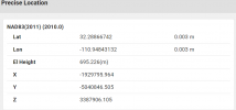
I did look at the map, and there is something weird. Two Bases near me have the wrong longitude in the details section. The XYZ is correct though.
 
The location on the map is from the GEOD network, which purposely obfuscates the location for privacy. However, on the ROCK Network Map, the precise location of the OPUS solution is shown at the bottom of the information panel when you click on More Details.

1697994198309.png

I have three of the ROCK bases. One at my house, one at the lab facility near downtown, and a third that was supposed to go up in Phoenix. That location fell through, so I installed it at the new office in Tucson, although I would still like to find a location a bit further East. Someone installed another base in Phoenix, which covers my two projects there, so I am good now.

They have made some changes since the network was launched earlier this year. The monthly subscription price went up about $5. When I purchased my bases, they provided a "free" network subscription with the base; I figured that was the "reward" for buying, installing, and hosting the base. However, the account they now provide with each base has access to only that base. If you want to access other bases in the network, you need to purchase the network subscription. So that is less of an incentive to install your own base unless there is not one already where you need it.

I suspect the cost of maintaining and operating the network may be higher than they originally figured. On the plus side, they are now bringing in more non-ROCK bases from the GEOD network that they have determined are stable enough. That has probably increased their costs a bit while providing better network coverage.

I assume you use the version where you host the base and receive free access to the network?

I did look at the map, and there is something weird. Two Bases near me have the wrong longitude in the details section. The XYZ is correct though.
 
Lycus Tech Mavic Air 3 Case

DJI Drone Deals

New Threads

Forum statistics

Threads
131,141
Messages
1,560,299
Members
160,109
Latest member
brokerman