

I have been going to a lot of waterfalls recently and they are shrouded by trees and the number of satellites is only close to 5-7. I only recently became aware of fly aways, so I am concerned. But once I take off and go above the trees, I am pretty sure I can get full satellites. How do you guys handle flying in such places?
You are using an out of date browser. It may not display this or other websites correctly.
You should upgrade or use an alternative browser.
You should upgrade or use an alternative browser.
Taking off inside a forest
- Thread starter jonatious
- Start date

Lastrexking
Well-Known Member
Carefully.
Make sure your home point is recorded, and set your RTH altitude accordingly.
Make sure your home point is recorded, and set your RTH altitude accordingly.
D
Deleted member 103366
Guest
It is rock solid without GPS providing the ground underneath it is suitable, it uses the downwards looking sensors. HOWEVER I believe flying over water can give those sensors trouble so be careful.
Also be aware that
1) wind conditions above the trees may be significantly different from those within the forest.
2) RTH climbs and descents are vertical though you can give manual inputs.
Remember also that if RTH is triggered within 20m of the home point the drone will start to land WHERE IT IS and will NOT attempt to reach the home point.
RTH is flown in P mode so be careful of the wind speeds above the trees.
I would also suggest you practice resetting the home point (so that you know how to do it BEFORE it is a must) in a safe and open field. The drone may well set or reset the home point once it has a good GPS lock and if it does that home point may not be where you want it to be.
Investigate what happens in RTH if it loses GPS lock
Guitarzan
Well-Known Member
Wise choice grasshopper...I agree! One time I had to launch under trees by a river bank, to shoot an old grain mill on other side, and had to make a strong note to myself...do NOT use RTH!Carefully.
Make sure your home point is recorded, and set your RTH altitude accordingly.
Dave Maine
Well-Known Member
- Joined
- Jan 27, 2018
- Messages
- 1,547
- Reactions
- 1,123
- Age
- 82
Can't see that anyone else have said it, so ...
Perhaps you also should consider changing the failsafe RTH behavior from RTH to Hover if ... 1. it's preferably solid ground below the AC (if you can't reach it quick enough before low battery landing) &/or 2. it's a short walk to the AC position to regain connection.
This can be the best solution if your HP have trees above it, making a straight descend impossible there or the AC just can't ascend up due to over hanging trees on the route.
Marv McCarthy
Active Member
I can't remember where I read this, I know it was from a DJI manual but don't recall which... It is important to let the drone hover at 7m or below for a few seconds if you want to record an accurate home point with the vision sensors. I guess the drone needs time to assemble the patterns. I've found that helps in tight spots. Also, if you have room to use a bright landing pad it helps the sensors by creating a more distinct pattern to return to. As far as water goes, the visual systems have a really hard time with it because there is not enough pattern variation, so if your drone starts acting weird over water and you are under 11m or so, raise altitude so that the visual system will not be fighting with your GPS for control of the drone.I have been going to a lot of waterfalls recently and they are shrouded by trees and the number of satellites is only close to 5-7. I only recently became aware of fly aways, so I am concerned. But once I take off and go above the trees, I am pretty sure I can get full satellites. How do you guys handle flying in such places?
I can't remember where I read this, I know it was from a DJI manual but don't recall which... It is important to let the drone hover at 7m or below for a few seconds if you want to record an accurate home point with the vision sensors. I guess the drone needs time to assemble the patterns. I've found that helps in tight spots. Also, if you have room to use a bright landing pad it helps the sensors by creating a more distinct pattern to return to. As far as water goes, the visual systems have a really hard time with it because there is not enough pattern variation, so if your drone starts acting weird over water and you are under 11m or so, raise altitude so that the visual system will not be fighting with your GPS for control of the drone.
I definitely did not know about bright landing pads making a difference. Will keep that on mind, thanks for sharing
")
I live in the forest. I mostly fly from my house which is surrounded by 150ft tall pine trees. I typically have to wait a bit longer to get a sufficient number of satellites for a solid GPS lock. It rarely happens but if I don’t get enough satellites I don’t take off. I think it is a recipe for potential trouble to hope that you will get more satellites after you take off. I haven’t had a single issue in a year and a half with this strategy.
- Joined
- May 25, 2017
- Messages
- 8,476
- Reactions
- 7,967
- Age
- 63
What aircraft ?
They all have little idiosyncrasies with how the behave . . .
RTH distance from Home point, if flying straight up and not moving away from Home point enough to enable RTH to work without immediate landing.
Ability to set failsafe signal loss to hover, so it doesn't rise into tree canopy if signal lost, or if above canopy, doesn't try and land into canopy.
GPS is a concern, especially recording accurate Home point, for accurate RTH if this is suitable and set right, and good stability of flight for take off.
More importantly, if you are below tree canopy, it is very possible / likely you could lose signal, initiating whatever failsafe option you have set.
Sometimes it's better to hover, move around until signal is regained and control restored.
Marv McCarthy
Active Member
Of course! Have fun!I definitely did not know about bright landing pads making a difference. Will keep that on mind, thanks for sharing
dennyc39
Well-Known Member
I have been going to a lot of waterfalls recently and they are shrouded by trees and the number of satellites is only close to 5-7. I only recently became aware of fly aways, so I am concerned. But once I take off and go above the trees, I am pretty sure I can get full satellites. How do you guys handle flying in such places?
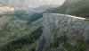
I have photographed several waterfalls, and with geology interest sometimes record places I can't easily get to. Only one mishap so far (in two years). The drone has never done anything I didn't tell it to do, even stupid things.
1. Don't fly underneath anything (bridge, overpass) that might mask GPS signal.
2. If the area is congested, forested, etc. consider using Hover as a loss-of-signal choice. Then you can approach closer while it waits for you rather than climbing blindly into a tree canopy.
3. Use down-camera to check out your vertical path before descending.
4. Be patient. Don't move sideways or backward without rotating the drone into that direction and look at the video to check for obstructions.
5. Tripod mode is quite useful.
6. I sometimes use prop guards, but be aware that they will make the drone less wind-tolerant.
7. Wind check: When you get above treetop height, hover for a bit and check your attitude indicator. Any tilt in a hover indicates wind and you can interpret that to read wind direction. Turn 90 degrees and check again. Abnormally slow speed moving in some direction indicates a headwind.
8. Best tactical situation is if you can fly into the wind outbound and with your back to the sun.
Attachments
LazerMan
Well-Known Member
Yea first time I was in a forest and didn't change my rth I had a problem. it went into rth while under trees and yep up she went into the trees 6 times before i got control. 2 things I set it to hoover and never lose sight of it. LOL
charliesRig
Well-Known Member
- Joined
- May 27, 2017
- Messages
- 991
- Reactions
- 1,271
I would never Fly My Mavic Pro In a forest,.......... (again).
it did not end well.
I would Fly in a forest with my Mavic 2 Pro and do without issues......
the avoidance sensors get stricky in tight spots.
very do-able
.
.
.
.....cR
.
.
it did not end well.
I would Fly in a forest with my Mavic 2 Pro and do without issues......
the avoidance sensors get stricky in tight spots.
very do-able
.
.
.
.....cR
.
.
Attachments

D
Deleted member 103366
Guest
charliesRig
Well-Known Member
- Joined
- May 27, 2017
- Messages
- 991
- Reactions
- 1,271
.Charlie, if not too painfully you should add a photo of the aftermath.
.....cR
.
.
Lionfish
Well-Known Member
I’m also surrounded by trees , Spruce , pine and aspen , so I totally agree with your recommendations, it can be an issue getting enough satellites but above the trees I get 18 or so depending on the day .I live in the forest. I mostly fly from my house which is surrounded by 150ft tall pine trees. I typically have to wait a bit longer to get a sufficient number of satellites for a solid GPS lock. It rarely happens but if I don’t get enough satellites I don’t take off. I think it is a recipe for potential trouble to hope that you will get more satellites after you take off. I haven’t had a single issue in a year and a half with this strategy.
It also means being extra careful with RTH settings.
Similar threads
- Replies
- 21
- Views
- 6K
- Replies
- 7
- Views
- 778


DJI Drone Deals
New Threads
-
 3 From Govedartsi to Mechit peak and back
- Started by alex_markov
- Replies: 0
-
 Last Week's Most Popular Topics (January 24, 2026)
- Started by msinger
- Replies: 0
-

-
 400 ft above structures doesn't override controlled airspace
- Started by Xitor
- Replies: 2
-

Forum statistics
