DJI Mavic, Air and Mini Drones
Friendly, Helpful & Knowledgeable Community
Join Us Now

UAV NFZ

Fatjac

Active Member
Joined
Dec 20, 2017
Messages
32
Reactions
1
Age
69
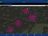
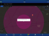
Hi could anyone explain to me how the vertical profile of a UAV or DJI NFZ looks please? I am using UAV Forecast & it seems that there are 2 concentric magenta circles over an airport near me. I don't quite understand what that implies.

TIA

Gary
 
Last edited:
I don't use UAV Forecast but I have seen their maps. I think that they use magenta to represent larger airports. I assume that UAV Forecast is trying to represent the shelves of the airspace around that particular airport with the magenta concentric rings. If you look at their legend it says magenta is a large airport. DJI doesn't show profiles, they just have big circles around airports, heliports, NFZ, etc... so there is not profile. If you want to see the real airspace profile go to Skyvector and look at the actual charts.
 
I recall it being something to the effect of the darker circle being set as a NFZ you should not fly in at all with the larger somewhat lighter as an area you need permission to fly from the tower
 
I don't use UAV Forecast but I have seen their maps. I think that they use magenta to represent larger airports. I assume that UAV Forecast is trying to represent the shelves of the airspace around that particular airport with the magenta concentric rings. If you look at their legend it says magenta is a large airport. DJI doesn't show profiles, they just have big circles around airports, heliports, NFZ, etc... so there is not profile. If you want to see the real airspace profile go to Skyvector and look at the actual charts.

It's frustrating when you are very near a small airport but unable to fly because of Djigo app even though you are in class G airspace below 700'
 
I recall it being something to the effect of the darker circle being set as a NFZ you should not fly in at all with the larger somewhat lighter as an area you need permission to fly from the tower

I’m not sure that is the case in the UK but I could be wrong. Thanks.
 
I obviously don’t want to fly through the ATZ and I have successfully flown where the location pin is ie. y garden BUT I would like to know what a side view of this second zone is...what is the altitude limit? Since posting I have read elsewhere that it could be a slope fro ground level up to the altitude limit point. So like an upside down triangle...
 
Lycus Tech Mavic Air 3 Case

DJI Drone Deals

New Threads

Forum statistics

Threads
132,317
Messages
1,572,038
Members
161,047
Latest member
inventoryahead0