DJI Mavic, Air and Mini Drones
Friendly, Helpful & Knowledgeable Community
Join Us Now

3 Wahkeena Falls in the Columbia River Gorge

AlanL

Well-Known Member
Premium Pilot
Joined
Dec 26, 2021
Messages
631
Reactions
1,195
Age
74
Location
Vancouver, Washington
This is a 2 shot vertical panorama of Wahkeena Falls using the 24mm lens on my Mavic 3. Two captures processed with DxO PureRAW3 and merged in Lightroom. I cropped out some sky at the top as it didn't really add to the composition.

Wahkeena is actually a long series of rapids and cascades as can be seen from above with a view that is not possible from ground level. These falls call for a cloudy day this time of year as they are in constant shadow and any hint of the sky will blow your exposure to pieces. I learned this lesson the hard way after years of shooting with a DSLR in the Gorge.

It should be noted that you cannot fly any closer to these falls without being in violation of a USFS No Fly zone which extends from Wahkeena Falls to Multnomah Falls and extends inland from the Union Pacific Rails.
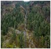
DJI_M3-162-WahkeenaPano033023.jpg

Comments and critiques always welcome.
 
I've always wanted to go up there and fly around the gorge but it was always too windy. I'll have to do that this summer when I find out where I can launch legally
 
I've always wanted to go up there and fly around the gorge but it was always too windy. I'll have to do that this summer when I find out where I can launch legally
Check local weather underground stations near where you want to fly to get a clue about the winds. I often use North Bonnville as a rough estimate.

Also track the atmospheric pressure conditions - if there is a low off the coast and high pressure on the east side of the Cascades it is unlikely you will have favorable conditions. I encountered some stiff winds a few weeks back (30mph gusts) and quickly discovered flying up there under those conditions was not a Good Idea(TM).

Typically METAR reports are best for aviation weather conditions but there aren't a lot of airstrips in the Gorge so local info is lacking.

For flight restrictions check the USFS web site that has details. The link at the bottom shows some good maps of the No Flights zones.
Thanks for that info. That will provide necessary info. I know someone in Vancouver that I visit frequently thru out the year and it seems that every time I was there from Hood River to Multnomah it was always windy. But I am determined to fly up there this year. :) I'd like to start at the Cascade Locks.
 
Nice photo
 
  • Like
Reactions: AlanL

DJI Drone Deals

New Threads

Forum statistics

Threads
131,238
Messages
1,561,157
Members
160,190
Latest member
NotSure