DJI Mavic, Air and Mini Drones
Friendly, Helpful & Knowledgeable Community
Join Us Now

3 What’s your best “non-aerial” drone shot?

landmark orbiter

Well-Known Member
Joined
Aug 26, 2023
Messages
101
Reactions
115
Location
The Midlands, United Kingdom
What’s your best drone shot where you’ve used it to get into place that you couldn’t?

It’s a picture that doesn’t look like it was taken with a drone… for example flying down to the bottom of some cliffs and looking up? I don’t have one btw.
 
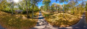
Here is one that I captured in 2022... It is a pano of a greenway near my home showcasing fall colors. To me, it looks as though it could have been taken by someone standing with a 16-35 or wider lens mounted on a camera... particularly if they were standing on a small step ladder.PANO0001-Pano-Edit-Edit-4.jpg
 
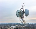
Here is another one that I captured yesterday of two workmen repairing a microwave antenna. While it was captured from a drone, I grabbed similar imaged from ground level on a hill with my Sony A7RIV and a 400mm lens...DJI_20240103102255_0266_D_MBMA3-Edit.jpg
 
The primary reason I fly a drone at all is to hover in places I can't get to on the ground for landscape photography. I rarely ever shoot video.

A couple of examples:

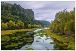
The view from the base of Crown Point in the Columbia River Gorge. The drone is hovering about 15' above the surface of Mirror Lake in Rooster Rock State Park on the Oregon side of the Columbia River. Single shot at 24mm on a Mavic 3 Pro.

DJI_M3P_24_CRG-MirrorLake-CrownPoint.jpg

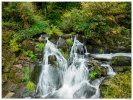
Beaver Creek Falls in the Siuslaw National Forest. The Mavic 3 drone is hovering about 15' over a pool at the base of the falls. The trail ends off to the right with no head on view of the falls. There are tree branches about 3' behind the drone and some about 5' overhead. 24mm. While I was standing at a small viewpoint about 20' away from the drone if it went down there would be no possibility of recovery with steep terrain and a high flow rate below the falls.

DJI_M3-BeaverCreekFalls2.jpg
 
The primary reason I fly a drone at all is to hover in places I can't get to on the ground for landscape photography. I rarely ever shoot video.

A couple of examples:

The view from the base of Crown Point in the Columbia River Gorge. The drone is hovering about 15' above the surface of Mirror Lake in Rooster Rock State Park on the Oregon side of the Columbia River. Single shot at 24mm on a Mavic 3 Pro.

View attachment 171593

Beaver Creek Falls in the Siuslaw National Forest. The Mavic 3 drone is hovering about 15' over a pool at the base of the falls. The trail ends off to the right with no head on view of the falls. There are tree branches about 3' behind the drone and some about 5' overhead. 24mm. While I was standing at a small viewpoint about 20' away from the drone if it went down there would be no possibility of recovery with steep terrain and a high flow rate below the falls.

View attachment 171594
Both excellent images Alan and perfect height for the captures. The slow shutter speed to blur the water was a nice touch.

Dale
Miami
 
Both excellent images Alan and perfect height for the captures. The slow shutter speed to blur the water was a nice touch.

Dale
Miami
Thanks Dale - the waterfall image is actually 5 shots in burst mode with median blending in Photoshop.
 
  • Like
Reactions: MS Coast
Thanks Dale - the waterfall image is actually 5 shots in burst mode with median blending in Photoshop.
Would you please tell me the steps you took in Photoshop after I open all 5 images into Photoshop?
 
Would you please tell me the steps you took in Photoshop after I open all 5 images into Photoshop?
My workflow for this is based on Lightroom so if you are a dedicated ACR fan you will have to improvise the first steps. In this case I took all of the images in the burst and run them through DxO PureRAW to clean up the DNGs and then made all of my light/color adjustments on one of the images. I then Sync'ed all of the images in the set to this one.

1. Highlight all of the captures and use Open in Photoshop as Layers.

2. Highlight all of the layers and then use Edit>Auto-align Layers. Use the default Auto setting for alignment.

3. With all of the layers still highlighted do Layer>Smart Objects>Convert to Smart Object. PS will collapse all of the layers into a single object.

4. Then do Layer>Smart Object>Stack Mode>Median and PS will use median blending mode which should only impact the waterfall. The result will still be a Smart Object so depending on your PS workflow you may wish to Rasterize the image for your remaining edits (I do).

There are other blending modes in PS for step 4 and Mean is that other possibility depending on your subject and the number of captures you are working with. I tend to prefer Median but YMMV.
 
  • Like
Reactions: passedpawn
The primary reason I fly a drone at all is to hover in places I can't get to on the ground for landscape photography. I rarely ever shoot video.

A couple of examples:

The view from the base of Crown Point in the Columbia River Gorge. The drone is hovering about 15' above the surface of Mirror Lake in Rooster Rock State Park on the Oregon side of the Columbia River. Single shot at 24mm on a Mavic 3 Pro.

View attachment 171593

Beaver Creek Falls in the Siuslaw National Forest. The Mavic 3 drone is hovering about 15' over a pool at the base of the falls. The trail ends off to the right with no head on view of the falls. There are tree branches about 3' behind the drone and some about 5' overhead. 24mm. While I was standing at a small viewpoint about 20' away from the drone if it went down there would be no possibility of recovery with steep terrain and a high flow rate below the falls.

View attachment 171594
Before I zoomed in on the first one, I thought that was a pterodactyl flying toward us. It's ok, I got in closer and realized it's a more recent photo.
 
My workflow for this is based on Lightroom so if you are a dedicated ACR fan you will have to improvise the first steps. In this case I took all of the images in the burst and run them through DxO PureRAW to clean up the DNGs and then made all of my light/color adjustments on one of the images. I then Sync'ed all of the images in the set to this one.

1. Highlight all of the captures and use Open in Photoshop as Layers.

2. Highlight all of the layers and then use Edit>Auto-align Layers. Use the default Auto setting for alignment.

3. With all of the layers still highlighted do Layer>Smart Objects>Convert to Smart Object. PS will collapse all of the layers into a single object.

4. Then do Layer>Smart Object>Stack Mode>Median and PS will use median blending mode which should only impact the waterfall. The result will still be a Smart Object so depending on your PS workflow you may wish to Rasterize the image for your remaining edits (I do).

There are other blending modes in PS for step 4 and Mean is that other possibility depending on your subject and the number of captures you are working with. I tend to prefer Median but YMMV.
Very grateful for this Alan. I can do everything in ACR that can be done in Lightroom-it is the same Adobe engine.
 
Very grateful for this Alan. I can do everything in ACR that can be done in Lightroom-it is the same Adobe engine.

Correct - the step I am not sure of is opening all of the burst captures as layers in PS directly from ACR which is an easy step from LR since it also my cataloging application.
 
Before I zoomed in on the first one, I thought that was a pterodactyl flying toward us. It's ok, I got in closer and realized it's a more recent photo.
A pterodactyl would be beyond a seriously cool capture :cool:

I didn't notice any up in the Gorge when I shot this in October.....
 
A pterodactyl would be beyond a seriously cool capture :cool:

I didn't notice any up in the Gorge when I shot this in October.....
If I spotted one, I'd fly after it and try to get better shots... and hope he didn't eat my Mavic.
 
  • Haha
Reactions: AlanL
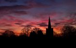
Here's one. Looks like it could have been taken from ground level but, in fact, this church is on the edge of an escarpment. In order to get the church against the eastern sky, you can't stand at ground level because you're either at the bottom of the escarpment looking almost vertically upwards or standing in the churchyard (in which case you're amongst the trees and too close to the church to see it properly anyway). This shot is - so to speak - taken by walking off the cliff and backing up about 20 yards.

53493913281_c138018278_o.jpg
 
  • Like
Reactions: AlanL
Very nice photos!
 

DJI Drone Deals

New Threads

Forum statistics

Threads
134,669
Messages
1,597,369
Members
163,149
Latest member
strudladi
Want to Remove this Ad? Simply login or create a free account