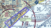
I don't understand why NOTAMs need to be so hard to read. Trying to understand the following NOTAM for CRE. I would be operating in class E4 airspace between CRE and MBY in Myrtle Beach South Carolina, but there is a NOTAM that also indicates the following;
!CRE 01/002 CRE AIRSPACE UAS WI AN AREA DEFINED AS 333818N0785619W (2.8NM S MYR) TO 334030N0785853W (2.2NM W MYR) TO 334652N0784835W (8.3NM NE MYR) TO 334543N0784654W (9NM NE MYR) TO POINT OF ORIGIN SFC-200FT AGL 2101051849-2112312359
I suspect this is a notice to airmen flying into CRE that there could be drone operations below 200' AGL on their approach or takeoff because a lot of vacationers bring drones with them? I suspect a lot of people fly drones along the stretch of beach in Myrtle Beach, but why just the mention of 200' AGL? Some of this is Class C, some G and some E4.


