DJI Mavic, Air and Mini Drones
Friendly, Helpful & Knowledgeable Community
Join Us Now

What is the point of LAANC as it is currently deployed?

Ok controlled air space. I get it. Trying to learn but...I have an airport in the next town, Andrews, N.C. and the code is RHP. If I go to "before you fly" it shows that there are no restrictions at the airport!!! Why is this? If you are interested in looking at this airport on an actual air map, go to the extreme west of N.C. and heading east you will see Murphy and then Andrews.
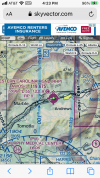
To help you with your learning experience, you should add sky vector.com to your tool box. This will provide you with FAA sectional charts which will help you determine what class airspace you are in, example KRHP, class E Airspace.
1629405745932.png
Blue Skys& Happy Contrails ➰
B52-D
 
  • Like
Reactions: BigAl07
OMG, why is this even a topic? LAANC is ONLY there to make getting approval in controlled airspace more convenient to the UAS pilot and prevent unnecessary burden on ATC's. It is and never was meant to be a "data collection tool". Why is this such a hard concept to understand? Why would anyone give two cents of thought to something like this? Normally, people would be happy that the government is not sharing our information with everyone. Jeesh. I do agree that DJI's GEO fencing is a PITA and they need to make it easier to coordinate LAANC approvals with it.
This kind of attitude is somewhat annoying. "OMG, why do people even bother to interchange information to try to understand things? I totally know I understand things, here, let me wave my hands and say nothing of substance, there, do you get it, why is that so hard to understand?"

The only answer that I've seen in the entire thread that even tries to address the root of the original question I asked was someone saying "LAANC helps by denying you if there is an active reason to deny you". And in that sense, it probably does help, if it really does deny you if there is a plane inbound or something. If it only denies you for TFRs, then it's much less useful, anyone who can file for LAANC doesn't need LAANC to know about TFRs.

Otherwise as far as I can tell (and anyone else can tell, if this thread is evidence) it's a fairly useless system as it's currently implemented. It'd be like having a restaurant requiring reservations to get a table. The reservation process would be done via an automated system and would require no lead time, you could reserve the table for immediate use. The reservation would be automatically approved in all instances, regardless of if someone had already made a reservation for that table at the same time you want it. The reservations would not be publicly visible, nor would the restaurant employees have access to it (or even know it exists) to let customers know that the table is reserved. There would be no enforcement of the reservations whatsoever, and nobody would ever check to see if you have a reservation or not when you sat down, they'd just take your word for it. But they'd be absolutely required because that is restaurant policy. This policy makes sense because it's much better than the previous policy which was exactly the same, other than it required you to fill out paperwork months in advance to get a table. Nobody enforced that policy either, of course, but this is much better because it is so much easier, wouldn't you agree?
 
OMG, why is this even a topic? LAANC is ONLY there to make getting approval in controlled airspace more convenient to the UAS pilot and prevent unnecessary burden on ATC's. It is and never was meant to be a "data collection tool". Why is this such a hard concept to understand? Why would anyone give two cents of thought to something like this? Normally, people would be happy that the government is not sharing our information with everyone. Jeesh. I do agree that DJI's GEO fencing is a PITA and they need to make it easier to coordinate LAANC approvals with it.
??
 
Let's talk about LAANC.

chakalakasp offers a thoughtful analysis and makes a valid point. If nobody uses or even wants the LAANC outputs then it's just another example of government waste. It could at nearly zero cost be replaced with a static map showing the altitudes below which once can safely fly without seeking authorization.

What's more, the law abiding pilot who files with the system sets himself up to be blamed for the actions of anyone else who might be flying in the area illegally. In reality, LAANC doesn't do ANYTHING to prevent violations of controlled airspace.

Responding "Rules are rules, just do it" is to miss his point completely.
 
Last edited:
In reality, LAANC doesn't do ANYTHING to prevent violations of controlled airspace.
Especially those who don't even know what controlled airspace is!

But it should make you (as a savvy drone operator) aware there are lower level AGL guidelines to follow in some areas. A main issue is there are people with drones completely ignorant to the rules. LAANC also doesn't prevent a drone operator to fly at 1200' AGL either. I feel LAANC is not enforcement and more about obtaining authorization to follow necessary guidelines to keep the drone operator in compliance with the grid altitude limits. It won't stop a person with an entitlement attitude who feels compelled to break rules.

I for one wouldn't want to be in court trying to defend why I was flying out of compliance if I were involved in any type of aviation incident (especially within a LAANC grid) that causes injury or damage to people and/or property.
 
So basically the reason it exists is for the furtherance of administrative paperwork? I mean it’s not even a tax, like registering your car. It’s just filing for permission from something that automagically grants it and said permission is immediately thrown into a dark hole where nobody ever looks at it again. If you don’t do it and something goes wrong they fine you for not doing it, even though having done it would have made no functional difference to the situation. If you do file for it and something goes wrong they fine you for not abiding by the conditions of the approval, which again, has no real function other than to serve as some kind of legal instrument to fulfill some law that probably was never meant to be applied to flying objects that fit in your pocket.

I guess I’m just disappointed that LAANC seems to have no real function other than to fulfill some legal rubber stamp requirement. If ATC and pilots don’t want / need this info then functionally there is no reason for it to exist. (Unless there is some expectation that in the future such a need will exist, as UAS operations flourish and the space becomes more crowded).
LAANC as it exists has been a game changer for professional drone operators. At least for me it has. Also most newer, unhacked drones won't even start up in GEO Zones until an auth is received.

As a professional and certified drone operator, I almost preferred the old way of having to request clearance by working with ATC/FAA/Local because, also being a SEL certified private pilot, I was familiar with those comms and it put me ahead of the competition who couldn't get clearance to fly in GEO Zones. Now it's so easy that anyone can get clearance. :(
 
  • Like
Reactions: BigAl07
Especially those who don't even know what controlled airspace is!

But it should make you (as a savvy drone operator) aware there are lower level AGL guidelines to follow in some areas. A main issue is there are people with drones completely ignorant to the rules. LAANC also doesn't prevent a drone operator to fly at 1200' AGL either. I feel LAANC is not enforcement and more about obtaining authorization to follow necessary guidelines to keep the drone operator in compliance with the grid altitude limits. It won't stop a person with an entitlement attitude who feels compelled to break rules.

I for one wouldn't want to be in court trying to defend why I was flying out of compliance if I were involved in any type of aviation incident (especially within a LAANC grid) that causes injury or damage to people and/or property.
So far nobody seems to be in court much at all for anything related to drones; there's all sorts of idiocy out there in YouTube land and it seems like people have to literally race commuter trains across major bridges and livestream themselves buzzing skyscrapers in downtown Boston at 1.5kft before anything happens. I mean, if that's all LAANC is good for -- to be some legal rubber stamp that the state needs for legal reasons, then it fulfills a purpose of sorts, at least for the state -- just not any kind of purpose that is useful to actually helping to keep the airspace safe.

As much as I hate GeoFences I feel like they'd do a much better job of preventing casual stupidity and violating ATC rules. Most people who'd file for LAANC don't need LAANC to know what the rules are.
 
If you look at 1800wx it only shows drones that have special permission. I Fly next to Miami international airport on a lake that I have approval to fly at 125 ft. Usually fly there on the weekends. It never shows my purple circle in 1800wx. At the beginning when Laanc started it did show.
 
@chakalakasp the vast majority of your "wishes" will come true with the roll-out of Remote ID. Be careful what you wish for though...

I can assure you the current LAANC works great and it does deny for anything outside of the "approved procedures" which is what really matters anyway. Why would you want every UAS operation that falls within allowable procedures to cause more work on ATC?

I don't exactly understand your comment
"if it really does deny you if there is a plane inbound or something" ???

You don't understand how LAANC works at all. It's a system with predetermined "acceptable flight procedures" in established "Grid" sections. If you request a flight in a specific area and your requested criteria does not exceed any of the parameters you are ACCEPTED/Approved. Your request doesn't initiate a query for all inbound flights and then cross reference your proposed flights with those or anything. The ATC (or whoever is controlling that specific airspace) has taken a great amount of time and planning to have predetermined procedures that are APPROVED.

It's also important for everyone using LAANC to understand that just because you get approved in a section one time doesn't mean it will always be that way. Airport Traffic is a very dynamic and fluid process and things can change that would make a previously viable request denied. This could include maintenance on equipment/runway etc, some type of special flight procedure changes (some type of special operations happening), or any number of issues that would deem a certain section/grid temporarily "Denied". It's rare but it could happen. Our local airport has a large grassy area parallel to the runway (slightly off airport property) and occasionally there are some training operations carried out in that area and you'll get denied for flights in that section if it's ACTIVE for training.


If you look at 1800wx it only shows drones that have special permission. I Fly next to Miami international airport on a lake that I have approval to fly at 125 ft. Usually fly there on the weekends. It never shows my purple circle in 1800wx. At the beginning when Laanc started it did show.

Initially we created DROTAMs (Section 333 Exemptions etc) for flights in and around controlled airspace but with the proliferation of UAS and the ease of flights with new GPS/Stabilization systems the NOTAM system was swamped with "Purple Circles". Then you have those people who grossly abused the system and created DROTAMS for large areas for crazy long periods of times. We saw several who created a DROTAM for anywhere they "might" be flying for an entire YEAR. The map was littered with tons or purple circles and they became effectively useless due to absurd abuse.
 
Lycus Tech Mavic Air 3 Case

DJI Drone Deals

New Threads

Forum statistics

Threads
131,129
Messages
1,560,124
Members
160,099
Latest member
tflys78