DJI Mavic, Air and Mini Drones
Friendly, Helpful & Knowledgeable Community
Join Us Now

Why does DJI's Geo mapping show (presumably) extended runway vectors?

vindibona1

Well-Known Member
Joined
Jun 21, 2020
Messages
3,977
Reactions
3,961
Location
Democratic Peoples Republic of Crook County
There have been a few times that I've needed to unlock DJI's geofencing. I had an issue that really wasn't so much a Flysafe issue but a settings issue within my Mavic 2, which even their support person didn't understand, not did he understand airspace. The conversation I had with him showed that he was not only unfamiliar with the internal settings of the M2, but didn't recognize that the DJI maps in some ways contradict actual air maps. They seem to have some strange runway extension/vector thing off of airports which can only confuse pilots trying to understand where NFZs may or may not be.

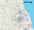
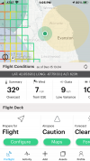
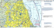
Below find the DJI map with (presumably) runway extension vector designations, followed by the Kittyhawk map of the same section, followed by Skyvector's sectional map of the area. I do not understand why DJI includes these extra vectors when they don't represent airspace designation espectially the areas that do not even require any ATC authorization? In fact, when the front line DJI support person took my phone call he told me that I was in a "restricted area" when I clearly am not. [See red dot on sectional map and note floor of Class B space]

Perhaps I'm missing something, so can someone explain to me the logic of these extensions on DJI's maps????
1608323935922.png

kittyhawk.pngkord_sectional map.png
 
DJI geofencing in my opinion seems to correlate well with FAA facilities maps.

In your first image, I can't tell where you are in relation to the second.
 
Perhaps I'm missing something, so can someone explain to me the logic of these extensions on DJI's maps????
View attachment 119630
I live just off of one of these "extensions". In fact they are a improvement and redesign of the old geo system DJI used way back. Before it would have been a huge circle of NFZ around airport, now they have opened up the NFZ. Now they serve to let you know that aircraft will or can be at a much lower altitude due to approach or take off. Even though I live off the actual designation I routinly have to drop altitude due to aircraft being 400 Ft or lower in my area.
 
Last edited:
So that ignorant people don't fly into areas or elevations that regulations don't want you to and the nature of air traffic would make it unwise. The actions they would have to take would or should make them fully aware of the situation. No claims of "I didn't know".

Now I have seen FAA facilities maps be a bit overreach in some areas, but not completely unreasonable.
I understand what you're saying, but as I was a newbie not all that long ago, while I was aware of Airmap and Kittyhawk I had no clue that DJI had any kind of map at all. I never looked at it until I had a problem with geofencing, and then, having experience with other maps, and even now look at those runway extensions and say to myself "WTF?". They don't represent geofencing. They don't represent any altitude. If outside of the NFZ zones what do they do? IMO- nothing but confuse a lot of folks. If you're outside of any area that requires ATC authorization, the floor of any restricted space is going to be higher than 400' AGL. If people are ignorant of the 400' ceiling no DJI map is going to help. FWIW, if you look at that DJI map around O'Hare Intl and the extended vectors... They don't truly represent air traffic, No other airmap that I've seen has them. So why has DJI taken this route? IMO it would have made more sense to make a "pink" zone around the other perimeters rather than artificial and nonsensical vectors that don't mean anything.

A couple editorial thoughts in regard to all of this. I believe it is high time that we, as a society, started promoting and demanding personal individual responsibility instead of governmental mandates or corporate caveats. We demand that people change behaviors all the time and enforce them socially. Responsibility and freedom are two side of the same coin and one cancels the other. Without one you cannot have the other. In so many cases, in so many areas we have long crossed the line of governmental and corporate over-reach and overkill. And with these mandates we have forgotten the notion that just because it's legal doesn't make it right. We've forgotten our moral responsibilities. We restrict everyone because one or two imbeciles get out of line.... and those imbeciles usually keep on doing what they're doing. And BTW... if you haven't noticed, getting back to the DJI map thing, if you're close to an NFZ your controller or phone program is going to tell you... even if you're miles away. What's the point of useless features on maps that nobody looks at anyway until forced to by lock-outs?

Dismounting soap box.
 
Again, there is a correlation between FAA facilities map and DJI Flymap. You might want to read up on DJI zones in Flysafe. I'm sure the user manual mentions geofencing.

Most of the time you'll see blue authorization zones along runway approach paths. Besides this area being a high risk of traffic, much of the time FAA has zero altitude there anyway. Also much of the time FAA will have an altitude limit at the ends of the runway approach path. You'll usually find approach be zero for much of it's length, then jump to 200ft, then 400ft after which you're out of controlled airspace.
DJI mimics that.

I agree seems redundant to limit altitude to 400 ft in facilities map and DJI zones when you're not supposed to fly above 400ft even in G space, but people do, either ignorantly or purposefully.

For major airports, restricted and authorization zones may be applied close around the airport.
 
I think you will find those runway extensions correlate with European flight rules. While it means an extra step at times by having to go through the unlock procedure, it also helps make those that don’t learn about sectional charts and USS facilities maps aware they are in an area that could pose danger to manned flights. DJI adopted a strategy/standard for NFZ zones and applied it to all maps. Can you imagine the nightmare of trying to incorporate each country’s regulations into a single map application and fit it into an app to run on a smart phone?

While my personal feelings tend toward not having a software/firmware nanny on my sUAS and placing the responsibility of safe flight and adhering to regulations on myself, I fully understand why many sUAS manufacturers include such on their consumer level aircraft. Until countries enact policies of no purchase until you can prove knowledge of applicable rules, we will have built in nannies.
 
Last edited:
There have been a few times that I've needed to unlock DJI's geofencing. I had an issue that really wasn't so much a Flysafe issue but a settings issue within my Mavic 2, which even their support person didn't understand, not did he understand airspace. The conversation I had with him showed that he was not only unfamiliar with the internal settings of the M2, but didn't recognize that the DJI maps in some ways contradict actual air maps. They seem to have some strange runway extension/vector thing off of airports which can only confuse pilots trying to understand where NFZs may or may not be.

Below find the DJI map with (presumably) runway extension vector designations, followed by the Kittyhawk map of the same section, followed by Skyvector's sectional map of the area. I do not understand why DJI includes these extra vectors when they don't represent airspace designation espectially the areas that do not even require any ATC authorization? In fact, when the front line DJI support person took my phone call he told me that I was in a "restricted area" when I clearly am not. [See red dot on sectional map and note floor of Class B space]

Perhaps I'm missing something, so can someone explain to me the logic of these extensions on DJI's maps????

View attachment 119630

View attachment 119631View attachment 119632
It’s overkill on the safety issue you’re probably trying to make a good impression for the FAA
 
The grey fan-shaped runway extensions are altitude restrictions. (60m and 150m)
See this:
www.dji.com/ca/flysafe/introduction
Thank you for the link. As I look at the charts provided in the link, at least in the case of my local airspace, the DJI maps contradict what is on the sectional maps. If the gray area is a 400' limitation, I have to ask why they have a 400' limitation when Class G space extends to 1900' MSL (approximately 1300' AGL)? There are a few buildings in my area, about 7nm from O'Hare, that if a rooftop inspection were needed I could, without ATC authorization fly up to 600' AGL. Any planes coming out of O'Hare would probably be directed to be far above that by the time they are 7 miles off the runway. Yet DJI has that silly gray vector, which I presume would lock me out of ascending beyond 400' AGL. I shouldn't have to consult any map other than a standard sectional map to know how high and where I can fly.

Yeah I know there are idiots out there, which I presume will, in the future, ultimately invoke a required basic airman's knowledge test to be able to fly all but toy drones. I think I would actually support such an idea if it can help reduce the idiocracy.
 
Have you looked at the FAA facilities map for that location? From what I see using Airmap to view the facilities map grid, it's pretty big.

But if you feel Flysafe is wrong, you can write to [email protected]
 
I just took a look at that area, comparing the NE corner of the facilities map following I55 and comparing to DJI's geomap. The altitude zone does overextend a bit, and the 60m altitude limit which equates to about 200ft is low since facilities map has it at 250ft but geomap only uses two altitudes for their zones: 60m and 150m.

Even FAA is overcautious. By me, FAA has it at 0 altitude just about the entire 5 miles of the airspace along the approach path, but at O'Hare, you get altitude a lot sooner.
 
in the case of my local airspace, the DJI maps contradict what is on the sectional maps.
DJI's Geo Zones often don't accurately reflect actual sectional maps, and sometimes they miss stuff altogether.

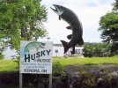
Four years ago we did a cross-Canada road trip and made a brief stop in Kenora, Ontario. There's a nice little park on the north edge of Kenora Bay featuring Husky the Muskie, a 40' tall 2.5 ton statue of a muskie fish. In the middle of the bay is a huge water fountain, and across the bay is the marina and waterfront of the town of Kenora. It seemed like the perfect scenic spot for a quick flight with my Phantom 3 Pro.

Husky-the-Muskie.jpg

But, before even unpacking my Phantom, I noticed several float-planes taxiing in the bay, to and from the seaplane dock located across the bay. Hmmmm, they seem far enough away. As long as I stay on this side of the bay, at or below tree-top height, I should be okay to fly, no?

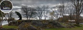
Nope! Just then a big medevac helicopter came roaring by at treetop height to land at the hospital pad located a mere 250m from where I was standing. Yikes! I'm just a tourist, passing through. How am I supposed to know that's a hospital right there?

KenoraBay.jpg

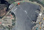
The helicopter pad, hidden from the road, was literally 250m from where I was standing! The seaplane dock, with many planes busily departing and arriving, was a mere 450m across the bay. Okay, sigh, so it's really not a good idea to fly my drone here, eh.

Distance.jpg

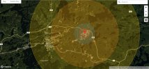
DJI's Geo Zone map today still shows only Kenora Airport's 6000' runway located 10km away. This park with Husky the Muskie falls within the Yellow warning zone of Kenora Airport, but there's no indication on the Geo Zone map of any hospital heliport or seaplane aerodrome.

Clearly, it's not enough to rely solely on DJI's Geo Zones. Know where you are and what's around you before attempting to fly!

Kenora-DJI.jpg
 
DJI's Geo Zone map today still shows only Kenora Airport's 6000' runway located 10km away. This park with Husky the Muskie falls within the Yellow warning zone of Kenora Airport, but there's no indication on the Geo Zone map of any hospital heliport or seaplane aerodrome.

Clearly, it's not enough to rely solely on DJI's Geo Zones. Know where you are and what's around you before attempting to fly!
You sort have made my point from the opposite direction. When in an unfamiliar area I always consult Airmap and/or Kittyhawk first, never flying without checking. It's just a bunch of stupid circles with Knights of Columbus crosses coming out of them. No real information to help pilots. Useless except for predicting where you might be locked out.

I never even knew that a flysafe map existed until the first time I got locked out. And the silly thing was that I already had ATC authorization for the flight, but could not self unlock. In fact, I have never been able to find whatever area in the Fly/Go4 apps to let me self unlock on my phone. I had to go home, get on the computer where I was advised to do a CUSTOM unlock from the computer. One other time I did a preemptive custom unlock knowing that I'd be too close to a regional airport. And while I already had ATC authorization for the time I wanted to fly, I knew that if I got out there and found myself locked out I wouldn't be able to do anything from there.

I get what DJI is trying to do. They know that they are the deep pockets should one of their users do something stupid with one of their drones and the sharks come after them- because they can. But IMO, this geofence stuff should only be applied in CRITICAL areas with imminent danger. Beyond that, how is it DJI's responsibility?
 
  • Like
Reactions: pinballwiz86
To begin self-unlock in authorization zones, simply try to start motors with CSC. This also gives you more info when it simply says not good to fly.
 
That's not true, every time I fly into one [fan-shaped runway extension] it requires permission acknowledgement and confirmation form

The Grey fan-shaped runway extensions are always Altitude restrictions. Blue fan-shaped runway extensions are Authorization Zones.

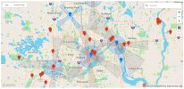
This is from DJI's Geo Zone map for your Minneapolis area. Note some areas are Red Restricted Zones, some are Blue Authorization Zones, and some are Grey Altitude Zones.

Minneapolis.jpg

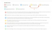
Note that by default the map does not display Orange Enhanced Warning Zones, or Yellow Warning Zones. You need to check the boxes to have those displayed. Here's a list of the various types of Geo Zones.

Zones.jpg

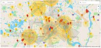
With those two boxes checked as well, the map becomes much busier. Fan-shaped runway extensions can be several different types of Geo Zones. While the Grey ones are still only Altitude Zones (60m and 150m), they can overlap other Zones to trigger multiple warnings.

All.jpg
 
There have been a few times that I've needed to unlock DJI's geofencing. I had an issue that really wasn't so much a Flysafe issue but a settings issue within my Mavic 2, which even their support person didn't understand, not did he understand airspace. The conversation I had with him showed that he was not only unfamiliar with the internal settings of the M2, but didn't recognize that the DJI maps in some ways contradict actual air maps. They seem to have some strange runway extension/vector thing off of airports which can only confuse pilots trying to understand where NFZs may or may not be.

Below find the DJI map with (presumably) runway extension vector designations, followed by the Kittyhawk map of the same section, followed by Skyvector's sectional map of the area. I do not understand why DJI includes these extra vectors when they don't represent airspace designation espectially the areas that do not even require any ATC authorization? In fact, when the front line DJI support person took my phone call he told me that I was in a "restricted area" when I clearly am not. [See red dot on sectional map and note floor of Class B space]

Perhaps I'm missing something, so can someone explain to me the logic of these extensions on DJI's maps????

View attachment 119630

View attachment 119631View attachment 119632
Those are approach and departure corridors IFR...airplanes at lower altitudes.
 
  • Like
Reactions: BigAl07
Lycus Tech Mavic Air 3 Case

DJI Drone Deals

Forum statistics

Threads
130,589
Messages
1,554,147
Members
159,592
Latest member
MaxRichu