

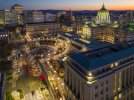
I wanted to do some photography in an area within a restricted altitude due to an airport. The area I wanted to photograph was around the PA State Capitol building. A portion of the Capitol Complex is in the 200 ft zone and the remainder in a 400 ft zone. FWIW, the capitol dome is 272 ft high inside, but I felt a photo from 200 ft was better than nothing. To make sure I was compliant with the law - and because the AirMap maps showing the area indicated that the actual area had 2 quadrants marked as 200 ft and 2 adjacent quadrants at 400 ft, I was prepared to have to go through 4 LAANC requests which would have made it awkward and limited my ability to move around the site.
But when I got there and powered up the drone, (in a 200 ft quadrant) I immediately got a message that I was in a restricted zone and had to keep my altitude below 150M. Since 120M is approximately 400 ft and I cannot fly higher than that anyway, I clicked the box which indicated I accepted those restrictions and happily photographed the area. I have had this happen in other areas as well, but not often. Is this common in other areas?
But when I got there and powered up the drone, (in a 200 ft quadrant) I immediately got a message that I was in a restricted zone and had to keep my altitude below 150M. Since 120M is approximately 400 ft and I cannot fly higher than that anyway, I clicked the box which indicated I accepted those restrictions and happily photographed the area. I have had this happen in other areas as well, but not often. Is this common in other areas?


 L)
L)


