DJI Mavic, Air and Mini Drones
Friendly, Helpful & Knowledgeable Community
Join Us Now

An evening around Stonehenge, within the CAA rules

Interesting thread, what did the app indicate with regard to Stonehenge standing in a permanent Danger Area?

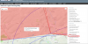
D125 Larkhill (Salisbury Ranges)
Danger Area
Surface to 50,000 Feet

Its not always activated (same with a lot of UK danger areas). You can check prior to flight by checking NOTAMs or even calling the MoD (or VHF marine or air if needed).

Generally speaking Larkhill is deactivated on weekends (Salisbury Plain Training Area (SPTA) firing times: July 2018 - GOV.UK).

The drone assist and other NOTAM apps will tell you if its currently activated or not.

IIRC Stonehenge is also just on the boundary as well and not actually in a danger area.
 
Last edited:
Its not always activated (same with a lot of UK danger areas). You can check prior to flight by checking NOTAMs or even calling the MoD (or VHF marine or air if needed).

Generally speaking Larkhill is deactivated on weekends (Salisbury Plain Training Area (SPTA) firing times: July 2018 - GOV.UK).

The drone assist and other NOTAM apps will tell you if its currently activated or not.

IIRC Stonehenge is also just on the boundary as well and not actually in a danger area.
Thank you for the information, I have since read some other info (more related to manned aircraft) on the subject and there is allegedly no requirement to contact the person/s responsible for the Danger Area however as it's labelled as such it could be considered incompetent if you do not. On the last point and according to the online aviation chart, Stonehenge is in the Permanent Danger Area. Thanks for your reply
 

Attachments

  • Stonehenge 1.png
    Stonehenge 1.png
    806.1 KB · Views: 12
Permanent danger from what? Hippies?

The military goes nowhere near Stonehenge, it's another example of an over zealous civil servant making life a misery for everyone.
 
Thank you for the information, I have since read some other info (more related to manned aircraft) on the subject and there is allegedly no requirement to contact the person/s responsible for the Danger Area however as it's labelled as such it could be considered incompetent if you do not. On the last point and according to the online aviation chart, Stonehenge is in the Permanent Danger Area. Thanks for your reply

Its not a "permanent danger area". Danger areas are ALL "permanent" in that they are on charts. However that doesn't mean they're always in use. Danger area need to be activated to be in use and that activation is normally for specific times and altitudes. Its all published in NOTAMs. You can check whether a specific danger area is activated by checking the NOTAMs (something everyone should do before flying a drone anyway, use the NATs Drone Assist app NOT airmap). As well as NOTAM you can call the MoD on the phone to request the status or if licensed use VHF airband (or marine).

The ICAO defines a danger area as:
A danger area is an airspace of defined dimensions within which activities dangerous to the flight of aircraft may exist at specified times. (ICAO Annex 11: Air Traffic Services)

(bold is mine).

If its not activated, in lieu of any permanent airspace restrictions theres no issue.

Every drone user SHOULD be checking NOTAMs for the area before taking off. Just because it was fine yesterday doesn't mean its fine today. Examples could be a small village or carnival that might have booked a flypast or parachute jump, an ongoing search and rescue operation and so on.

The military goes nowhere near Stonehenge, it's another example of an over zealous civil servant making life a misery for everyone.

No but they fly OVER stonehenge or nearby which is the whole point of the danger area. Currently 2 x AH64s operating about 2 miles to the north below 1000ft of it on MLAT tracking.
 
Aircraft overflying doesn't constitute a Danger Area in the accepted sense, quite the opposite as I'm sure you know; it's about danger TO aircraft from ordinance (live or otherwise) or low flying military aircraft. I'm very familiar with the whole Salisbury Plain area and have worked inside the MoD - and I'll say again, while the Salisbury campus might be marked as a danger area, as I expect Avebury is also, I haven't checked, the reality is they do not operate anywhere near those sites for very obvious reasons.
 
Aircraft performing high energy manoeuvres do constitute a danger area (which happens quite a lot). Danger areas are ground and airborne areas.
Danger areas are designed for aircraft not drones specifically so a lot of the things happening are irrelevent but there is no such thing as a low altitude UAS NOTAM or restriction under the ANO as such. Its all lumped in.
Landed now but the 2 AH64s were operating low level about 2nm from Stonehenge earlier. Also a 4 ship operating around Avebury and the area for night ops 2 nights ago so things are around in the area.
Its not an issue anyway, just see if the area is activated or not. If its not activated its perfectly legal to fly in them. If it is active, dont fly in it because if caught, breaking the ANO can be expensive, and more so after July 30th when the new rules come into play.

Most mavic owners cant even be arsed to read the manual so expecting them to be responsible enough to actually check a NOTAM before flying is asking a bit much.
 
  • Like
Reactions: Axelz
Much like the US National Parks, English Heritage wrongly state you cannot fly over their properties. But not wanting to annoy visitors or fall foul of the Crowded Area rule, I waited until closing time and got some nice shots circling the Stones.

There is a Restricted Air Space zone immediately to the north of the Stones, Larkhill, where Air Traffic Control advise only flying your drone with extreme caution. As it is, I didn't venture into that airspace.
But the idea of groundless prohibition of flying is annoying; landowners don't control airspace! I see this flight compeltely within CAA rules and I took off from common ground outside the National Trusts & English Heritage's boundaries. I didn't fly close to people, stayed above 50 metres and below 400', staying in VLOS, so with that, I think this flight was completely legitimate.
Always good to hear others' opionons though.


And for UK flyers, this really is the app to have, straight from National Air Traffic Control:

Safety Apps | Dronesafe

Cheers,
Ian
I think the problem is a lack of understanding on the part of these organisations, these measures assume someone is going to rock up in the car park, pull an Inspire 2 out of the boot and set up within the land/property/front lawn and fly around within close proximity in which case yes you would need their permission and comply to whatever rules they choose to impose including being insured and having a CAA PfCo or a PFAW as they call it? I don't see how they can stop legitimate flights within CAA rules without applying to CAA themselves to have the air space around the said property restricted.

Drone Filming Guidleines | English Heritage
Apols for the absense; was on holiday.
The NATS app states that even inside the Larkhill Controlled Airspace, you may fly your drone with caution, making sure you observe the Drone Code. So the NATS app specifically allows you to fly.
Over the summer solstice, there was indeed a NOTAM in palce, prohibiting all drones over the area. Which to me, further proved my point, as when they genuinely want to prohibit drones, they can and do.

It puts a smile on my face when I consider the thundering main road just around 200 yards from stonehenge, with huge trucks, lorries and cars going past all day. And the thousands of people that clamber amongst the stones every summer and winter soltice. Sometimes a little perspective is needed....

Cheers,
Ian
 
It puts a smile on my face when I consider the thundering main road just around 200 yards from stonehenge, with huge trucks, lorries and cars going past all day.

And the bikes!

I'm a biker, there's some cracking roads round that way :D

But yes, stand anywhere stone henge on a sunday morning and all you can hear is bikes screaming up and down the road :rolleyes: And when it's not sunday morning all you can hear is trucks thundering past at +50mph. There's no way you'd hear a drone disturbing the "peace and quiet" o_O

Sometimes a little perspective is needed

Amen to that my brother Thumbswayup
 
Apols for the absense; was on holiday.
The NATS app states that even inside the Larkhill Controlled Airspace, you may fly your drone with caution, making sure you observe the Drone Code. So the NATS app specifically allows you to fly.
Over the summer solstice, there was indeed a NOTAM in palce, prohibiting all drones over the area. Which to me, further proved my point, as when they genuinely want to prohibit drones, they can and do.

It puts a smile on my face when I consider the thundering main road just around 200 yards from stonehenge, with huge trucks, lorries and cars going past all day. And the thousands of people that clamber amongst the stones every summer and winter soltice. Sometimes a little perspective is needed....

Cheers,
Ian
Great Video and thread, with the new drone laws coming into force, the first part of which is the 30th of this month and mandatory registration by November next year, do you think drone pilots face further issues through inaccurate media reporting and hysteria.?

https://l.facebook.com/l.php?u=http...5_P3UOGX8JYnBl7g7chsWvvNt8ryFoZBDzaQUkhmXR2gw
 
Apols for the absense; was on holiday.
The NATS app states that even inside the Larkhill Controlled Airspace, you may fly your drone with caution, making sure you observe the Drone Code. So the NATS app specifically allows you to fly.
Over the summer solstice, there was indeed a NOTAM in palce, prohibiting all drones over the area. Which to me, further proved my point, as when they genuinely want to prohibit drones, they can and do.

It puts a smile on my face when I consider the thundering main road just around 200 yards from stonehenge, with huge trucks, lorries and cars going past all day. And the thousands of people that clamber amongst the stones every summer and winter soltice. Sometimes a little perspective is needed....

Cheers,
Ian

Not to mention that Stonehenge is surrounded by more than 2100 acres of National Trust land which the military cannot and do not operate over, whatever the plane spotters care to assert.
 
Not to mention that Stonehenge is surrounded by more than 2100 acres of National Trust land which the military cannot and do not operate over, whatever the plane spotters care to assert.

Other than they can and do operate over it along with plenty of other civilian aircraft.
They dont operate at low level but pass overhead all the time.
If you couldnt operate over NT land you couldnt actually fly anywhere in the UK.
 
Other than they can and do operate over it along with plenty of other civilian aircraft.
They dont operate at low level but pass overhead all the time.
If you couldnt operate over NT land you couldnt actually fly anywhere in the UK.

Just not at anything like the height a drone would be sensibly operating beneath. You get my point.
 
Much like the US National Parks, English Heritage wrongly state you cannot fly over their properties. But not wanting to annoy visitors or fall foul of the Crowded Area rule, I waited until closing time and got some nice shots circling the Stones.

There is a Restricted Air Space zone immediately to the north of the Stones, Larkhill, where Air Traffic Control advise only flying your drone with extreme caution. As it is, I didn't venture into that airspace.
But the idea of groundless prohibition of flying is annoying; landowners don't control airspace! I see this flight compeltely within CAA rules and I took off from common ground outside the National Trusts & English Heritage's boundaries. I didn't fly close to people, stayed above 50 metres and below 400', staying in VLOS, so with that, I think this flight was completely legitimate.
Always good to hear others' opionons though.


And for UK flyers, this really is the app to have, straight from National Air Traffic Control:

Safety Apps | Dronesafe

Cheers,
Ian
I feel the same way about state parks here in Minnesota. But I had a park ranger back me up by confirming they only have control over who lands and takes off from inside the park. Anything that doesn't touch the ground in the park is fair game. Thanks for sharing. Nice work
 
  • Like
Reactions: Ian in London
I actually think the new rules will help reduce the hysteria.... hopefully one day drone press stories will be as interesting as lawn bowls..... :)
 
Hello Chaps, a number of years ago I was employed as bus tour guide and was taking a bus load of Yanks around a few British landmarks. One of these sites happened to be Stonehenge, which so many always called "Stone Hedge", despite continued correction. I was standing near a couple, just behind them, as they looked at the stones, of course you could hear the traffic constantly. I then heard the husband say, "it's an amazing site Mildred, but it's a **** shame they built it so close to the road!"

On another point regarding photography of specific buildings and the discussion of copyright and trademark, I'm a Welshman but live in the US now. Near us is the Cleveland Rock and Roll Hall of Fame, a very distinctive building and now famous landmark. Many people take photos of it every day, of course, but several years ago, a photographer took a lovely shot of it and sold the image through a gallery, calling the image, what it was, the Rock and Roll Hall of Fame. That photographer was taken to court by the corporation owning the RRHF for taking the image and selling it. They won that case, however, they won it because they had a trademark on the name. The photographer took the image from a public place but when he sold it with its name, that is where the law got him.

Now anyone who takes a photo of this place and wants to sell it, be it an enlargement or on a card, they can do so as long as they don't title the image as The Rock and Roll Hall of Fame. Therefore, if you call it the Rock Hall, as many are now doing, you can get away with it and no one can do anything about it. I wonder if the same might be true back in the UK with the NT buildings, if an image is sold but with a different title/name to the image, if it might be the same sort of thing?

Just my two peneth worth, or is it penath? This thread has been an interesting read.
 
  • Like
Reactions: Ping^Spike
Just not at anything like the height a drone would be sensibly operating beneath. You get my point.

250ft? Perfectly within drone height. And rotary wing army height (and done weekly).
 
Lycus Tech Mavic Air 3 Case

DJI Drone Deals

New Threads

Forum statistics

Threads
130,589
Messages
1,554,146
Members
159,592
Latest member
MaxRichu