DJI Mavic, Air and Mini Drones
Friendly, Helpful & Knowledgeable Community
Join Us Now

An unexpected (and happy) Airspace authorization

spamgnome

Well-Known Member
Joined
Jan 14, 2019
Messages
772
Reactions
899
Lots of threads on here about people struggling with authorization/ DJI complications when wanting to fly in places here droning is unobstructed. This is actually a success story, and one that was a bit unexpected.
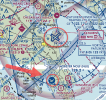
I was vacationing in MD recently in a place called St. Mary's and the area I wanted to fly in was in a hornet's nest of Naval facilities and Restricted Airspace. (see sectional, below) What to do...I REALLY wanted to fly here.

1) Get the self-unlock code from DJI's site. Got the code OK, but then had some struggles getting the Fly app to accept it (apparently a known issue).
2) Request a LAANC...bwahaha...not even close to being an option here.
3) Call Patuxent "PAX" approach to request clearance below the R-4004 & R-4007. These both go to 18,000 feet.
4) Enter the DJI-supplied unlock code and get the rotors to start spinning.

I thought for sure that I would get laughed at, but surprisingly they gave me an hour to fly, in the middle of the day. The only 2 requests were to keep it below 200' and call them back when I was done.

Just another example of, "You don't get it unless you ask."
1634055835778.png
 
Was your authorization for Part 107 or for Rec flight?
 
107...but they didn't ask
Pretty sure - at least as far as I understand the rules - rec pilots aren't supposed to call ATC for clearances... lol. If they do, they are to be referred to a LAANC provider.

I found the text here:


There are two ways to use LAANC:
  • Receive a near real-time authorization for operations under 400 feet in controlled airspace around airports (available to Part 107 Pilots and Recreational Flyers).
  • Submit a "further coordination request" if you need to fly above the designated altitude ceiling in a UAS Facility Map, up to 400 feet.
    • You can apply up to 90 days in advance of a flight and the approval is coordinated manually through the FAA (available to Part 107 pilots only).
 
Last edited:
Pretty sure - at least as far as I understand the rules - rec pilots aren't supposed to call ATC for clearances... lol. If they do, they are to be referred to a LAANC provider.

I found the text here:


There are two ways to use LAANC:
  • Receive a near real-time authorization for operations under 400 feet in controlled airspace around airports (available to Part 107 Pilots and Recreational Flyers).
  • Submit a "further coordination request" if you need to fly above the designated altitude ceiling in a UAS Facility Map, up to 400 feet.
    • You can apply up to 90 days in advance of a flight and the approval is coordinated manually through the FAA (available to Part 107 pilots only).
Where he flew wasn't in controlled airspace. LAANC wasn't an option. Contacting ATC if you're flying in a Military Operations Area (MOA) or Restricted Airspace is the correct procedure.
 
Excellent story and THANK YOU for taking the time to write and share it!!
 
  • Like
Reactions: theDRONEranger
Since Southwest Airlines is canceling flights I guess there was open air space for you. LOL 🙃

Glad it all worked out the way it should for a change.
 
Lots of threads on here about people struggling with authorization/ DJI complications when wanting to fly in places here droning is unobstructed. This is actually a success story, and one that was a bit unexpected.
I was vacationing in MD recently in a place called St. Mary's and the area I wanted to fly in was in a hornet's nest of Naval facilities and Restricted Airspace. (see sectional, below) What to do...I REALLY wanted to fly here.

1) Get the self-unlock code from DJI's site. Got the code OK, but then had some struggles getting the Fly app to accept it (apparently a known issue).
2) Request a LAANC...bwahaha...not even close to being an option here.
3) Call Patuxent "PAX" approach to request clearance below the R-4004 & R-4007. These both go to 18,000 feet.
4) Enter the DJI-supplied unlock code and get the rotors to start spinning.

I thought for sure that I would get laughed at, but surprisingly they gave me an hour to fly, in the middle of the day. The only 2 requests were to keep it below 200' and call them back when I was done.

Just another example of, "You don't get it unless you ask."

View attachment 136445
Pax River is a very hot area for flights / testing; so getting some flying time was a great thing.

Time to post some photos / vids!
 
  • Like
Reactions: BigAl07
The FAA link (post #4) above does mention National Authorization then links to that page that never mentions them. Figured if you had ins at the FAA you could find out what they are talking about.

ps: If that arrow points to where he wanted to fly, he most certainly was in controlled airspace, and seeking further information absolutely was the correct thing to do. An MOA is controlled airspace - whether or not it is active. Plus, even if the MOA didn't exist on the map, it is still marked Class E, and Class E is still considered controlled airspace.

Plus, there is this tldr: 1.1.2.5 NAS Patuxent River Class D Airspace with Class E Extensions, and some carve outs for low flying GA flights to 800' in this letter:

Okay, that National Authorization. That is no longer valid. That was only necessary if you wanted to use LAANC and fly outside daylight hours. All LAANC providers now off LAANC and 107.29 ops. So the National Authorization is no longer around.

The arrow isn't in "Controlled Airspace" that is LAANC able. The "controlled" airspace would be Echo at 700'. So there is no authorization needed, nor is there one even available. And there are some E Extensions there (E2, dashed magenta line) that require permission, but not where he is flying. Again, assuming the arrow indicates position.
Yes, the arrow indicates where I was flying. While the PAX NAS is in fact Class D, the Webster OLF, which is the airport right across the water from where I was, is also marked as SUA (Special Use Airspace) just like the Restricted areas. As for LAANC, I believe one can only use it for the areas around B, C, and D airports. All other areas require direct telephone contact, which is what I did. One thing I did NOT do, but probably should have, is get the name of the person I was speaking to just in case...there was no record of the clearance that was in my possession. Pretty sure all calls to ATC are recorded though. There's just a TON of overlapping airspace in that area.
 
Yes, the arrow indicates where I was flying. While the PAX NAS is in fact Class D, the Webster OLF, which is the airport right across the water from where I was, is also marked as SUA (Special Use Airspace) just like the Restricted areas. As for LAANC, I believe one can only use it for the areas around B, C, and D airports.
Close. LAANC is only good for (most) civilian B, C, D, and E2 (E Surface).
All other areas require direct telephone contact, which is what I did. One thing I did NOT do, but probably should have, is get the name of the person I was speaking to just in case...there was no record of the clearance that was in my possession. Pretty sure all calls to ATC are recorded though. There's just a TON of overlapping airspace in that area.
And this discussion is strong proof of why it's so important for drone owners to understand airspace rules. Even more so is areas like this.

And all ATC do have recorded lines, but not all ATC lines are recorded. So it would depend on which line you called.
 
Close. LAANC is only good for (most) civilian B, C, D, and E2 (E Surface).


And all ATC do have recorded lines, but not all ATC lines are recorded. So it would depend on which line you called.
Doh! Missed the E2...you're right of course. BTW, for the airspace surrounding the NAS, LAANC isn't available...I would have had to do it the long way via DroneZone, and that would have taken more time than I had...I just wouldn't have flown at all.

I called PAX Approach as that was the phone number of the controlling entity for the Restricted areas shown in ForeFlight. I know that when I fly (airplanes) everything gets recorded, so I assumed (hoped?) that that would also be the case when I called...kind of like calling for an IFR departure clearance when on the ground at a podunk airport.
 
Lycus Tech Mavic Air 3 Case

DJI Drone Deals

New Threads

Forum statistics

Threads
131,244
Messages
1,561,227
Members
160,195
Latest member
vanillasky