You are using an out of date browser. It may not display this or other websites correctly.
You should upgrade or use an alternative browser.
You should upgrade or use an alternative browser.
Another lost Mavic Mini
- Thread starter whatthe2
- Start date
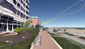
When you lost the connection you were up on 146ft ... way above that house in the end of the known flight path. The RTH height was set to 98ft which was below the altitude zone of 197ft & the failsafe action was set to RTH. Also nothing in the log indicate that your Mini hit something just in the end.
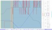
The wind speeds seems to have been low, nothing that would have made your Mini Blow away ...
But it's a bit odd that this is logged in the .TXT message stream though ... was it mild winds?

So in the end everything points to that your Mini should have returned home on 146ft against a pretty mild wind after you lost connection.
But here I'm pretty sure we see the reason for why you didn't see the Mini return ...
You launched in a hurry ... you didn't have a HP recorded when you got airborne ... the HP was recorded later along the flight path ... at 47sec into the flight, by then your Mini was out over the beach. And if you didn't know this you searched for your Mini in the wrong location.
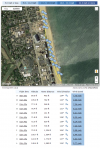
Here below in the chart I've placed the markers where the HP was recorded ... you can read off latitude & longitude for the recorded HP in the legend below the chart.
(Click on the chart to make it larger)
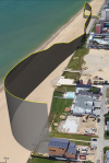
Here a part of the flight path on a sat picture ... the green star marks the HP. Your Mini most probably waiting for you there ... go get it ?

The wind speeds seems to have been low, nothing that would have made your Mini Blow away ...

But it's a bit odd that this is logged in the .TXT message stream though ... was it mild winds?

So in the end everything points to that your Mini should have returned home on 146ft against a pretty mild wind after you lost connection.
But here I'm pretty sure we see the reason for why you didn't see the Mini return ...
You launched in a hurry ... you didn't have a HP recorded when you got airborne ... the HP was recorded later along the flight path ... at 47sec into the flight, by then your Mini was out over the beach. And if you didn't know this you searched for your Mini in the wrong location.
Here below in the chart I've placed the markers where the HP was recorded ... you can read off latitude & longitude for the recorded HP in the legend below the chart.
(Click on the chart to make it larger)

Here a part of the flight path on a sat picture ... the green star marks the HP. Your Mini most probably waiting for you there ... go get it ?

Last edited:
slup, thanks for the help. I couldn't find it in that area, but I assume someone picked it up as it was likely just lying there on the beach for a while and it's pretty crowded today. But I appreciate you pointing out what I did wrong. Makes total sense now that I think about it as I got the updated HomePoint message in the area you mentioned. Should have known to look there first, but oh well.When you lost the connection you were up on 146ft ... way above that house in the end of the known flight path. The RTH height was set to 98ft which was below the altitude zone of 197ft & the failsafe action was set to RTH. Also nothing in the log indicate that your Mini hit something just in the end.
View attachment 134058
The wind speeds seems to have been low, nothing that would have made your Mini Blow away ...
View attachment 134056
But it's a bit odd that this is logged in the .TXT message stream though ... was it mild winds?
View attachment 134063
So in the end everything points to that your Mini should have returned home on 146ft against a pretty mild wind after you lost connection.
But here I'm pretty sure we see the reason for why you didn't see the Mini return ...
You launched in a hurry ... you didn't have a HP recorded when you got airborne ... the HP was recorded later along the flight path ... at 47sec into the flight, by then your Mini was out over the beach. And if you didn't know this you searched for your Mini in the wrong location.
Here below in the chart I've placed the markers where the HP was recorded ... you can read off latitude & longitude for the recorded HP in the legend below the chart.
(Click on the chart to make it larger)
View attachment 134064
Here a part of the flight path on a sat picture ... the green star marks the HP. Your Mini most probably waiting for you there ... go get it ?
View attachment 134065
Oh also, re: the strong wind warning. Got that as I got close to the water as it was likely a bit windier there, but all in all pretty mild. But as you mentioned likely had nothing to do with the problem here.
Maybe it will turn up. If not I've got my Air 2. Was going to give the mini to a friend and was doing a test flight after not flying it forever. Totally forgot to wait for the HomePoint. Lesson learned.
Slup, one more thing. I sat at my takeoff spot hoping it would come back. Would/should the controller reconnect to the aircraft at any point if it regains signal? Or once it's lost, it's lost? Was hoping it would RTH and I would gain control again, but I may be remembering incorrectly. Thanks again.
During normal circumstances & not with anything wonky going on with the connection It should have reconnected ... but if you pointed the RC wrongly and/or if the area was full of WiFi interference (all the hotels I see there in GE) it perhaps failed to do that.
Got it, thanks again.During normal circumstances & not with anything wonky going on with the connection It should have reconnected ... but if you pointed the RC wrongly and/or if the area was full of WiFi interference (all the hotels I see there in GE) it perhaps failed to do that.
IronSky1
Well-Known Member
- Joined
- Jan 16, 2019
- Messages
- 262
- Reactions
- 164
Dont be to quick to report flyaway like I did (in the first 12 hours). I found mine a day later and it took 3 weeks for DJI to release the serial number binding. (there software needs work on this). I finally had to send my mini in for replacement.
360 Guy
Well-Known Member
It most probably did, but not to the location the OP thought, check post #2. And by the way... Airdata's HP position is wrong.Yup. Don't know why it didn't come back though.
D_The_Producer
Well-Known Member
Such an amazing report!! ???When you lost the connection you were up on 146ft ... way above that house in the end of the known flight path. The RTH height was set to 98ft which was below the altitude zone of 197ft & the failsafe action was set to RTH. Also nothing in the log indicate that your Mini hit something just in the end.
View attachment 134058
The wind speeds seems to have been low, nothing that would have made your Mini Blow away ...
View attachment 134056
But it's a bit odd that this is logged in the .TXT message stream though ... was it mild winds?
View attachment 134063
So in the end everything points to that your Mini should have returned home on 146ft against a pretty mild wind after you lost connection.
But here I'm pretty sure we see the reason for why you didn't see the Mini return ...
You launched in a hurry ... you didn't have a HP recorded when you got airborne ... the HP was recorded later along the flight path ... at 47sec into the flight, by then your Mini was out over the beach. And if you didn't know this you searched for your Mini in the wrong location.
Here below in the chart I've placed the markers where the HP was recorded ... you can read off latitude & longitude for the recorded HP in the legend below the chart.
(Click on the chart to make it larger)
View attachment 134064
Here a part of the flight path on a sat picture ... the green star marks the HP. Your Mini most probably waiting for you there ... go get it ?
View attachment 134065
SQflyer
Member
Saw this report and immediately went and registered with AirData. So far I'm just doing the tier 1 free level but I uploaded today's log and was pleasantly surprised with the detail in the presentation. In looking a the report you posted, I'm wondering if the first image that shows the "curtain" view of the flight path, which allows one to see a 3D image of both the path plus altitude, was generated with AirData.When you lost the connection you were up on 146ft ... way above that house in the end of the known flight path. The RTH height was set to 98ft which was below the altitude zone of 197ft & the failsafe action was set to RTH. Also nothing in the log indicate that your Mini hit something just in the end.
View attachment 134058
The wind speeds seems to have been low, nothing that would have made your Mini Blow away ...
View attachment 134056
But it's a bit odd that this is logged in the .TXT message stream though ... was it mild winds?
View attachment 134063
So in the end everything points to that your Mini should have returned home on 146ft against a pretty mild wind after you lost connection.
But here I'm pretty sure we see the reason for why you didn't see the Mini return ...
You launched in a hurry ... you didn't have a HP recorded when you got airborne ... the HP was recorded later along the flight path ... at 47sec into the flight, by then your Mini was out over the beach. And if you didn't know this you searched for your Mini in the wrong location.
Here below in the chart I've placed the markers where the HP was recorded ... you can read off latitude & longitude for the recorded HP in the legend below the chart.
(Click on the chart to make it larger)
View attachment 134064
Here a part of the flight path on a sat picture ... the green star marks the HP. Your Mini most probably waiting for you there ... go get it ?
View attachment 134065
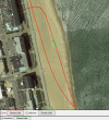
Sort of ... It's generated from the downloaded .KML file from Airdata. (Note that the HP is wrong in Airdata)...I'm wondering if the first image that shows the "curtain" view of the flight path, which allows one to see a 3D image of both the path plus altitude, was generated with AirData.
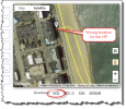
You can also upload the mobile device .TXT log to DJI Flight Log Viewer | Phantom Help & from there download their .KML file. (Here the HP is in the correct spot, totally corresponding with what's written in the original .TXT log)
(Click on the pic to make it larger)
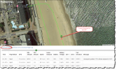
Once you have a .KML file over the flight locally on your computer you open it with Google Earth ... find the path in the left pane, right click on it & chose "Properties"
(Click on the pic to make it larger)
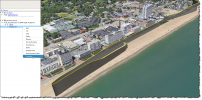
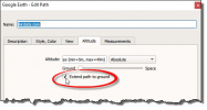
In the Properties, open the Altitude tab & check the "Extend path to ground" box ...
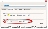
Then open the Style, Color tab & set it to "Filled" & adjust the opacity to your liking ...
Hit OK in the "Properties" window ... & you're done.
SQflyer
Member
Thanks for the great illustrated instructions slup! I'll give it a try!Sort of ... It's generated from the downloaded .KML file from Airdata. (Note that the HP is wrong in Airdata)
View attachment 134210
You can also upload the mobile device .TXT log to DJI Flight Log Viewer | Phantom Help & from there download their .KML file. (Here the HP is in the correct spot, totally corresponding with what's written in the original .TXT log)
(Click on the pic to make it larger)
View attachment 134211
Once you have a .KML file over the flight locally on your computer you open it with Google Earth ... find the path in the left pane, right click on it & chose "Properties"
(Click on the pic to make it larger)
View attachment 134212
In the Properties, open the Altitude tab & check the "Extend path to ground" box ...
View attachment 134213
Then open the Style, Color tab & set it to "Filled" & adjust the opacity to your liking ...
View attachment 134215
Hit OK in the "Properties" window ... & you're done.
Similar threads
- Replies
- 7
- Views
- 2K
- Replies
- 21
- Views
- 3K
- Replies
- 9
- Views
- 2K
- Replies
- 8
- Views
- 2K
- Replies
- 22
- Views
- 5K
Share:
DJI Drone Deals
New Threads
-
-
-
Air 3s Video settings tested - D-Log vs. HLG
- Started by DroneZone Samui
- Replies: 1
-
-
Mavic 3 classic purchased in the USA, on CE transmission profile?
- Started by Ossbourne
- Replies: 1


