You are using an out of date browser. It may not display this or other websites correctly.
You should upgrade or use an alternative browser.
You should upgrade or use an alternative browser.
Back on the altitude......
- Thread starter cheddar-man
- Start date
Tomk_
Well-Known Member
Well...you could get yourself a topographic map and plot your flight on it. Then if you know the difference in elevation from your home point at various distances from your home point, you could calculate a close idea of your AGL elevation using the readout from your drone.
My question would be why do you need to be at 400 AGL? unless there are some 400 ft high obstructions on that hill, it shouldn't be hard not to fly into the hill and not exceed 400ft AGL. I think it's harder coming down hill to make sure you don't get to high.
My question would be why do you need to be at 400 AGL? unless there are some 400 ft high obstructions on that hill, it shouldn't be hard not to fly into the hill and not exceed 400ft AGL. I think it's harder coming down hill to make sure you don't get to high.
Once you leave the home point it's all about making an educated questimate as your actual AGL altitude. Just make sure you're willing to stand by your estimate because if there is an incident you'll be held 100% accountable.
Tomk_
Well-Known Member
Here is a convoluted idea...
Take your drone up 300 ft. Set your gimbal at 0 degrees and turn your grids on. Find a spot on the hill that is at that altitude. Now you know that ground level at that point is 300 ft above your home point. Climb to 400 ft. and go to that point. When your gimbal is straight down and you are directly above it... you know you are 100 ft. AGL. Climb to 300 ft and find a new point. Wash/rinse/repeat.
Take your drone up 300 ft. Set your gimbal at 0 degrees and turn your grids on. Find a spot on the hill that is at that altitude. Now you know that ground level at that point is 300 ft above your home point. Climb to 400 ft. and go to that point. When your gimbal is straight down and you are directly above it... you know you are 100 ft. AGL. Climb to 300 ft and find a new point. Wash/rinse/repeat.
- Joined
- May 25, 2017
- Messages
- 8,476
- Reactions
- 7,966
- Age
- 63
Everything but a guesstimate is simply too difficult, time consuming, and just unrealistic for pilots to be doing before or during flights.
I'd hazard a guess and say most pilots don't generally fly at 400' anyway when taking video or photos, the best views, compositions, seem to be a lot lower, but yes there are exceptions.
In your scenario above, you could fly closer to the hill (or drop altitude), until you are at tree top height / ground level, read your altitude on the screen, then you know how far above you can go to be around the 400' AGL at that spot.
Eg. drop near the ground / tree tops where you had the arrows at B, say your alt there on the telemetry is 100', you can now fly up to 500' on your readout and be pretty safe.
- Joined
- May 25, 2017
- Messages
- 8,476
- Reactions
- 7,966
- Age
- 63
Here is a convoluted idea...
Take your drone up 300 ft. Set your gimbal at 0 degrees and turn your grids on. Find a spot on the hill that is at that altitude. Now you know that ground level at that point is 300 ft above your home point. Climb to 400 ft. and go to that point. When your gimbal is straight down and you are directly above it... you know you are 100 ft. AGL. Climb to 300 ft and find a new point. Wash/rinse/repeat.
Another good way to be fairly safe.
I use the grids on all the time anyway, for photos and for the fact a dead straight front gimbal the centre rectangle is where you can fly through things without hitting them
Tomk_
Well-Known Member
Dead reckoning using a topo map is the best way for my flights. Identify landmarks, know their altitudes before you fly.
Determine the maximum altitude for the region, set your max altitude to that so you are never 400' over the highest terrain you plan to be directly over. I use 200' over the highest as a safety measure and buffer. Then, know features that you can see as a waypoint from your launch location, then I use the camera to prove I am above the location for altitude checks. Most hills are not homogenous, and have trees or brush you can use for reference.
But US laws are different than British laws, so know the rules before you fly. 400' works here in the US, it may not work in the UK.
PVilardi
Active Member
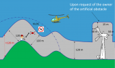
The left hand side of your diagram is wrong. The 120m isn't a radius from the top of the hill, it's a maximum vertical distance below the drone to the ground.400' AGL is self explanatory. Follow the terrain and maintain the 400'View attachment 143013
Not at all impossible. Just takes planning.All very well on paper, in theory, but almost impossible in practice as you don't know how high the drone is other than at take off point, impossible to follow contours once it beat a few feet away!
PVilardi
Active Member
Yes I think the diagram shows that. If you look at the red line it does show that area that is greater than 120m (400'). So it is up to the RPIC to maintain 400' AGLThe left hand side of your diagram is wrong. The 120m isn't a radius from the top of the hill, it's a maximum vertical distance below the drone to the ground.
The diagonal 120m lines are likely wrong, at least for the 400' / 120m rule in the US.Yes I think the diagram shows that. If you look at the red line it does show that area that is greater than 120m (400'). So it is up to the RPIC to maintain 400' AGL
It's correct for the UK and reflects the wording from CAAThe left hand side of your diagram is wrong. The 120m isn't a radius from the top of the hill, it's a maximum vertical distance below the drone to the ground.
There's an additional method that doesn't require a paper topography map. Although that certainly works and prior to cell phones (and all else digital in the world) we relied on those for pre flight planning in real aircraft....1970's era Cessna for example.
There are apps we can install on our phones which have topography contour lines overlayed onto satellite images, there's also digital topo maps and tools that are easily run by our phones. Too bad those topo lines and tools aren't already part of the maps within dji fly, that would be too simple!!
Some of these apps perform very similar to a handheld GPS. You can measure distance and acreage and mark waypoints, ect, etc, etc. A person can quickly measure a distance from take-off point (or any point) to any other given point and calculate the slope pretty easily. It's only going to be approximate but it'll be within 20 feet (or the accuracy of the contour interval).
In this example, if we ascend at a rate of 3 feet per 100 traveled, we're good.

Last edited:
Wade L.
Part 107 Certified
So then the 120m rule in the UK is in fact a radius from the center of the hill (or the shortest distance between the drone the nearest surface) and not directly below the drone? I’m just confused because the vertical red line on left is still technically on the hill, as are the two diagonal black lines. I’m certainly not disputing this, as I’m completely unfamiliar with the CAA rules - just trying to understand better. Thanks!It's correct for the UK and reflects the wording from CAA
hiflyer201
Well-Known Member
- Joined
- Sep 27, 2018
- Messages
- 2,740
- Reactions
- 2,167
You could look out the windowAs I approach the hill, point B, is there any way of telling how high I am above the ground?
I understand your question, When I first started flying drones, I had to google the height of the average power pole, light pole etc..I just didn't know, and what I've learned is that you don't know for sure. Situational awareness takes diligence and experience along with the understanding that you could be wrong.
Similar threads
- Replies
- 13
- Views
- 4K
- Replies
- 21
- Views
- 2K
- Replies
- 13
- Views
- 2K
- Replies
- 39
- Views
- 2K
DJI Drone Deals
New Threads
-
Hiring Remote Drone Pilots and Support Staff with CrewBloom
- Started by felixleo
- Replies: 1
-
3 Along the road to my daughters former school
- Started by alex_markov
- Replies: 0
-
Last Week's Most Popular Topics (December 13, 2025)
- Started by msinger
- Replies: 0
-
Members online
Total: 2,639 (members: 11, guests: 2,628)


