DJI Mavic, Air and Mini Drones
Friendly, Helpful & Knowledgeable Community
Join Us Now

Can I please get some help? I am heart Broken....

Adamisprimal

Active Member
Joined
Nov 3, 2021
Messages
39
Reactions
13
Age
33
Location
South Africa
Is there anyone here that can please advise me on what my Drone decided to do with the rest of its battery charge when my STUPID iPhone decided to freak out and no longer work with the app. The controller was beeping with the return to home sounds and it never came home and the cached video is only 9 seconds long. I pulled logs and I beg if someone can try help me figure out if it was trying to move toward the home point after the last recorded gps point or what. PLEASE PLEASE HELP
 

Attachments

  • DJIFlightRecord_2021-11-03_[18-18-11].txt
    719 KB · Views: 62
  • 2021-11-03 18_25_06-0K1UF5G00E01Q6.dat
    204 bytes · Views: 14
  • 2021-11-03 18_24_15-0K1UF5G00E01Q6.dat
    176 bytes · Views: 3
  • 2021-11-03 18_24_00-0K1UF5G00E01Q6.dat
    71 bytes · Views: 4
  • 2021-11-03 18_18_16-0K1UF5G00E01Q6.dat
    878 bytes · Views: 3
  • 2021-11-03 08_46_01-0K1UF5G00E01Q6.dat
    330 bytes · Views: 3
  • 2021-11-03 08_40_43-0K1UF5G00E01Q6.dat
    241 bytes · Views: 3
  • 2021-11-03 08_39_55-0K1UF5G00E01Q6.dat
    107 bytes · Views: 3
  • 2021-11-03 08_39_30-0K1UF5G00E01Q6.dat
    344 bytes · Views: 3
  • 2021-11-03 08_36_57-0K1UF5G00E01Q6.dat
    180 bytes · Views: 12
  • Like
Reactions: Droniac
The homepoint was set at 31.8sec, I think. That appears to be near enough over the start point of the Phantomhelp track.
It looks to me as if, towards the end of the log, the drone entered an RTH triggered by a button press at 371sec then perhaps a low battery RTH at 415.3sec.
Unfortunately you then switched flight mode to sport at 419sec and then back to P mode at 435sec, the log ends at 495sec. The above is from the csv of the flight.
The change of flight mode cancelled the RTH and left the drone flying under manual control.
If I am correct then what happened after that depends on what you commanded. I think the low battery auto land is set to trip at 10%.
You also seem to be rather high, 653ft above the take off point, which means a long descent if nothing else.
 
Last edited by a moderator:
Is there anyone here that can please advise me on what my Drone decided to do with the rest of its battery charge when my STUPID iPhone decided to freak out and no longer work with the app. The controller was beeping with the return to home sounds and it never came home and the cached video is only 9 seconds long. I pulled logs and I beg if someone can try help me figure out if it was trying to move toward the home point after the last recorded gps point or what.

If you lost the phone, that doesn't mean you lost connection to the drone, but it means we have no data to see what happened after that point.
All we can do it check the conditions and your settings to see what the drone might be expected to have done.

Your drone recorded a homepoint at the launch point.
You lost the phone and app at 8:15.2 with the drone 1190 metres out and 200 metres up.
Winds at that altitude were not a factor for consideration as the drone in RTH + right stick full forward was making headway toward the homepoint at close to normal full speed (8 metres/sec).

When you lost the phone/app, the drone was in P=GPS Mode with you doing the controlling.
Losing the phone/app that doesn't mean you lost connection and you could still control the drone without the app.

If you had continued to make joystick inputs, the drone would have followed them.
If you had pushed the RTH button, that would have initiated RTH.

But if you did nothing, the drone would have sat in the air waiting for you to do something or the battery to reach critical low voltage when it would have landed.

It's of interest to note that your Loss of Signal action was set to Hover, so if the drone lost the control signal from the controller, it would not have returned to home.
 
The homepoint was set at 31.8sec, I think. That appears to be near enough over the start point of the Phantomhelp track.
It looks to me as if, towards the end of the log, the drone entered an RTH triggered by a button press at 371sec then perhaps a low battery RTH at 415.3sec.
Unfortunately you then switched flight mode to sport at 419sec and then back to P mode at 435sec, the log ends at 495sec. The above is from the csv of the flight.
The change of flight mode cancelled the RTH and left the drone flying under manual control.
If I am correct then what happened after that depends on what you commanded. I think the low battery auto land is set to trip at 10%.
You also seem to be rather high, 653ft above the take off point, which means a long descent if nothing else.
my iphone was like lagging out and freaking out popping up sd card full and then froze and the controller had green light and was beeping like rth and I was like maybe I should not be doing manual flight cause the iphone lagging out made me panic and switch to sport and hold the home button. this is for some reason the only cached video that was saved and is there any log data or telemetry stored on the controller possibly as during the end moments I had the iphone not connected. I do know I have battery warning at 30%. I have a feeling it landed in the botanical gardens I hope. My scare is that it did a rth at 30 m height and ran into something. I hate myself for doing this range test more than you guys can understand... I am not the wealthiest and took a loan out for this guy and will be paying it off for 11 more months and I bought it on the 18th oct for myself as a early birthday gift for nov 14........ did the drone have a heading in the last few moments or was it stationary? I am optimistic and hope and pray to all the powers that be that it landed above the last recorded gps point cause if it did I have a chance to save my lil buddy. Looking at the kml from the link provided by the rockstar above in google earth looks like it was **** high up and I am not sure what the most likey path or actions it would of taken cause I see its at 6.3km/h for the last log. Also you guys are more than amazing and I am an idiot and learnt my lesson the **** hard way like I am 30 but I actually shed a tear or 2 over this event. Stupid of me to do the range test despite this you guys offered help and I am extremely thankful.
 
If you lost the phone, that doesn't mean you lost connection to the drone, but it means we have no data to see what happened after that point.
All we can do it check the conditions and your settings to see what the drone might be expected to have done.

Your drone recorded a homepoint at the launch point.
You lost the phone and app at 8:15.2 with the drone 1190 metres out and 200 metres up.
Winds at that altitude were not a factor for consideration as the drone in RTH + right stick full forward was making headway toward the homepoint at close to normal full speed (8 metres/sec).

When you lost the phone/app, the drone was in P=GPS Mode with you doing the controlling.
Losing the phone/app that doesn't mean you lost connection and you could still control the drone without the app.

If you had continued to make joystick inputs, the drone would have followed them.
If you had pushed the RTH button, that would have initiated RTH.

But if you did nothing, the drone would have sat in the air waiting for you to do something or the battery to reach critical low voltage when it would have landed.

It's of interest to note that your Loss of Signal action was set to Hover, so if the drone lost the control signal from the controller, it would not have returned to home.
I had a green light and beeping for like what felt like the scariest 10 - 15 seconds before I then got red flashing. I do hope it decided to hover and land my fear is it was heading home at the last gps marker shows 6.3 km/h speed. I pray I find it. I will be recording and posting to youtube the hunt for this guy in the botanical gardens(area under the last gps point. Thanks mate this is like next level help I humbly thank you Meta4
 
  • Like
Reactions: Droniac
I thank you kind soul. I am a dumbass and dont know wether to be positive its still alive or accept that I have lost the thing or go on the hunt. The google earth flight path looks like it may of gone further than the last point as the last recorded point the drone was moving
 
My scare is that it did a rth at 30 m height and ran into something.
DJI drones climb to the set RTH height to RTH.
If already above the set RTH height, they come home at the altitude tjhey are already at.
They never descend to RTH.
did the drone have a heading in the last few moments or was it stationary?
At the end of data the drone was moving forward at slow speed as you had just pushed the right stick forward and it was accelerating from rest.

I am not sure what the most likely path or actions it would have taken cause I see its at 6.3km/h for the last log.
If you kept the right stick pushed forward, the drone will have kept moving forward and gained speed.
If you took your hands off the joysticks, the drone would have stopped and hovered.

I'm not sure about your mention of the controller beeping to indicate RTH in progress.
That could only happen if you had initiated RTH as you did earlier in the flight.
 
The log is shows multiple downlink losses and that on loss of signal the drone went into hover mode rather than RTH. Perhaps RTH was triggered by the user, but LOS and other factors got in the way.

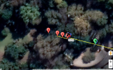
Drone stood still out at 3955 feet for a minute (7:02-8:10). That plus many other insufficient power warnings, and several low power battery warnings. And if the phone crashed - then it went back into hover somewhere near this building:
1635992002185.png

Ask the botanical garden staff if they found your drone.
 
The log is shows multiple downlink losses and that on loss of signal the drone went into hover mode rather than RTH. Perhaps RTH was triggered by the user, but LOS and other factors got in the way.
Losing downlink is not the same as losing the control signal.
Losing the downlink does not trigger RTH (or whatever the Failsafe Action is set to).
 
Not sure where you got that idea from.
He had good GPS signal for the whole flight and a homepoint set at the launch spot.
I didn't get that idea from any where other then what I saw on the map. It was more of a why is the map saying home point is so far away from where he was then saying this is your problem. Thanks for not offering an explanation.
 
I didn't get that idea from any where other then what I saw on the map. It was more of a why is the map saying home point is so far away from where he was then saying this is your problem. Thanks for not offering an explanation.
I looked at the data for the flight and it shows full GPS for the whole flight.
How much more explanation would you like?

The graphic you showed shows a position of 0°N 0°E
That's not a real position (but it doesn't show in the data for the flight).

 
I looked at the data for the flight and it shows full GPS for the whole flight.
How much more explanation would you like?

The graphic you showed shows a position of 0°N 0°E
That's not a real position (but it doesn't show in the data for the flight).

Is the map not generated from the data from the flight?
Well I guess the old saying "a picture is worth more than a thousand words" did not ring true this time.
Thanks for clearing that up I guess.
 
Is the map not generated from the data from the flight?
Well I guess the old saying "a picture is worth more than a thousand words" did not ring true this time.
Thanks for clearing that up I guess.
Where did your graphic come from?
When I open the link I posted above, what I see is:
i-x6Xh4JW-L.jpg
 
Where did your graphic come from?
When I open the link I posted above, what I see is:
i-x6Xh4JW-L.jpg
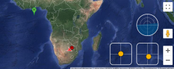
Keep expanding the map out until you see the continent of Africa.
From that view of the map it is showing home point to be at zero degrees latitude and zero degrees longitude (0°N 0°E).
in international waters in the Gulf of Guinea, in the Atlantic Ocean, off the coast of West Africa. I have seen this happen on other UAV's when GPS is lost or not set.
Just trying to understand the whole picture here, not saying your wrong in anyway.
 
Lycus Tech Mavic Air 3 Case

DJI Drone Deals

New Threads

Forum statistics

Threads
131,125
Messages
1,560,105
Members
160,099
Latest member
tflys78