DJI Mavic, Air and Mini Drones
Friendly, Helpful & Knowledgeable Community
Join Us Now

Canada - Parks Canada land

Google maps will show all of the green outlined parks. I faced this dilemma on my trip there last year.
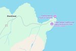
They're not parks. This is what Google Maps shows for Cape Spear.

googlemaps-cape-spear.jpg

...and according to Parks Canada report, this shows their area of jurisdiction (that's my quick photoshop job overlaying the area from the Cape Spear Management report...
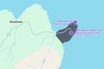
showing-Parks-Canadaboundary.jpg

Clearly, I'm not great with Google because I couldn't find this boundary on my own, but it seems set up to fail when its so convoluted.
 
If its a "preserve" issue or a nfz issue You simply need to find a VFR sectional chart for the area you want to fly. If it is something like a No Drone thing well....If they can't define the boundaries of the area then they can't define the area of their authority to ask you to stop. Not saying to just go flying, NO that would get you into a mess. BUT No Drone zones and "park" or "site" boundaries should be clear! at least to the people that make these boundaries.
If you simply bust the boundary while flying then unless there is a nature preserve there you are not breaking the law. If its anything like California and that site is a tourist trap..Forget it, anywhere within site of it will get you noticed and they will ask you to leave.
 
If its a "preserve" issue or a nfz issue You simply need to find a VFR sectional chart for the area you want to fly. If it is something like a No Drone thing well....If they can't define the boundaries of the area then they can't define the area of their authority to ask you to stop. Not saying to just go flying, NO that would get you into a mess. BUT No Drone zones and "park" or "site" boundaries should be clear! at least to the people that make these boundaries.
NAV Canada seems to do a decent job of showing aviation rules and boundaries, and the area in question is close to a flight path, with an altitude limit. That's all cool. It's only the park rules that really are problematic here, and I agree that the boundaries "should" be clear... but they're not. These are wide open areas, that have no visible signs of entering or leaving a designated area, other than obvious parking lots. I think I'm good with Cape Spear and Signal Hill now though, which are the Parks Canada covered areas of relevance to me in general. I don't think they have any other locations nearby

If you simply bust the boundary while flying then unless there is a nature preserve there you are not breaking the law. If its anything like California and that site is a tourist trap..Forget it, anywhere within site of it will get you noticed and they will ask you to leave.

We don't really have tourist traps. The population density for the island of Newfoundland, is about the same as North Dakota and while summer tourism is one of our significant industries, it never really gets busy here. I've been to Cape Spear for sunrise on multiple occasions during summer months, to take photos and video, and its been just me and a bunch of whales. Similarly for sunset. It's one of the things I love most about this place. The problem though is then the opposite - you're in a big open space, you're the only person around. If they spot you, they know its going to be you, even if you hide your controller. LOL.
 
I wrote to Parks Canada to try and get a map showing the boundaries of their sites here locally, so I can avoid them, since you're not allowed to fly on Parks Canada areas. They don't have such a thing apparently. The centre of sites is pretty obvious, and we have a couple of them, but I have no idea how far their land goes, they are not fenced, and they can't seem to tell me.

Anyone else come across this problem and solved it?
 

DJI Drone Deals

New Threads

Forum statistics

Threads
135,143
Messages
1,602,932
Members
163,631
Latest member
kkeller
Want to Remove this Ad? Simply login or create a free account