Greetings,
We are Theta Informatics LLC, creators of the OpenAthena software platform for iOS and Android.
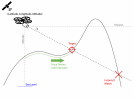
This free and open source software allows common drones to spot precise ground locations from any point within their images. This opens up entire new use cases for drones in search and rescue, agriculture, surveying, disaster response, and public safety users:


In this thread, we're interested in hearing your feedback regarding your commercial drone use. We want to understand common challenges you encounter with commercial drone use and how they might be addressed with software. Your feedback will help us determine product-market fit and the course of development of this project.
The most advanced version of the product is our version for iOS, which features automated elevation model management for calculations within any drone image:

 apps.apple.com
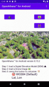
In our current Android version, elevation models must still be loaded manually:

 github.com
Known incompatible drone models:
We are Theta Informatics LLC, creators of the OpenAthena software platform for iOS and Android.
This free and open source software allows common drones to spot precise ground locations from any point within their images. This opens up entire new use cases for drones in search and rescue, agriculture, surveying, disaster response, and public safety users:


In this thread, we're interested in hearing your feedback regarding your commercial drone use. We want to understand common challenges you encounter with commercial drone use and how they might be addressed with software. Your feedback will help us determine product-market fit and the course of development of this project.
The most advanced version of the product is our version for iOS, which features automated elevation model management for calculations within any drone image:
OpenAthena App - App Store
Download OpenAthena by Robert Krupczak on the App Store. See screenshots, ratings and reviews, user tips, and more games like OpenAthena.
In our current Android version, elevation models must still be loaded manually:
GitHub - Theta-Limited/OpenAthenaAndroid: OpenAthena allows common drones to spot precise geodetic locations
OpenAthena allows common drones to spot precise geodetic locations - Theta-Limited/OpenAthenaAndroid
Known incompatible drone models:
- DJI Phantom 4 (not inc. Pro or Advanced versions, FC330 only)
- DJI Mini 2
- DJI Air 2 S (old firmware)


