DJI Mavic, Air and Mini Drones
Friendly, Helpful & Knowledgeable Community
Join Us Now

Connection/range issues on SC.

americandronecompany

Active Member
Joined
Feb 8, 2022
Messages
25
Reactions
29
Age
49
Location
Atlanta, GA
Hello folks
I am flying a Mavic 2 Zoom with a SC. Last week i was trying to capture a picture of this quarry which is probably about 750 - 850 ft from my launch point. Was flying at 380ft.
Almost got the entire pic. But as I was trying to get to the other end of the quarry....lost signal/connection.
Total freakout. had to hit that RTH.
I am pretty sure the quarry doesn't have any drone signal jamming system.
Is this a SC range issue? image(1).png
 

Attachments

  • 22-02-12-12-29-45_FLY093.DAT
    4.7 MB · Views: 11
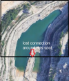
Here's your flight path stretched out down to ground ... HP marked & red cross where you lost the connection

1645121001271.png

And here you see the reason for the lost connection ... you were flying out of unobstructed line of sight with those 98m height above the HP, all the trees came in between the AC & the SC.

Note that the view below isn't quite from ground level when the red cross disappears behind the tree line.

1645121218067.png
 
This is amazing info. Wow...you were able to find out all those details. :)

"you were flying out of unobstructed line of sight with those 98m height above the HP, all the trees came in between the AC & the SC."
- anything I can do to prevent this from happening? Any advice you can share please.

Should I be able to run this analysis on my own for other missions. What software should I be using.
Thanks in advance.
 
One thing you can do to alleviate connection issues is to make sure you are facing the direction of the drone. Also make sure that the antennas are aiming down on the SC so they make a right angle with the controller.

You can get some penetration through trees but you want to optimize the situation to get the best you can.

You had some more altitude you could have gained before hitting the max of 400 ft. That can help also.
 
...- anything I can do to prevent this from happening? Any advice you can share please.

Should I be able to run this analysis on my own for other missions. What software should I be using.
Thanks in advance.
Keeping an unobstructed line of sight between your controller & craft is vital ... otherwise you risk losing the connection.

If you know that you need to fly out to an area & need to operate the craft from a distance where you have taller objects in front of you free LOS applies ... much can be planned before take off out from Google Earth on your computer for instance. What is the needed distance you need to fly out in order to capture what you want ..? Get that info from GE before you head out.

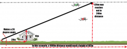
The below is what counts ... in the example below you're standing there to the left of the house. As you see, in the example you will only be able to fly out to 246m (807ft) if you stay at the maximum legal height of 120m (400ft), further out & you need to fly higher in order to come above the "shadow" from that house.

(Click on the picture to make it larger)
1645131777570.png

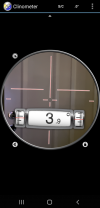
So once on the take off location you need to figure out that LOS angle ... I use an Android app called "Clinometer" & gauge towards the highest object into the flight path & the app gives me the angle ... then it's only a simple trigonometry calculation to see if I can reach out to the desired distance & at the same time keep within the maximum legal height.

This is the view in the app ... I just aim the cross hair to the top of the tallest object & the angle is shown. The longer horizontal line is the horizon ... so in the picture I'm aiming 3,9 degrees below the horizon.
1645132514576.png

In order to analyze the flight after worth ... you use flight logs.

You have 2 useful flight logs from a Mavic 2 Zoom ... both is stored in the mobile device (SC) you flew with. The easiest & most useful for telemetry analyses is the log that ends with .TXT. You retrieve it & upload it to --> DJI Flight Log Viewer | Phantom Help (on the site they explain where to find it, just scroll down there a bit).

Once uploaded you will get this graphical representation with data from the flight log with a possibility to "Fly" it by dragging that green dot under the sat.pic.

(Click on the picture to make it larger)
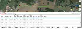
1645132979524.png

You can also from the above site download a .KML file (red circled) which you can open in Google Earth to get a 3D view of the flight path ... like below.
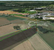
1645133105743.png

The log you uploaded earlier was the second usable flight log ... it ends with .DAT. This log is mostly useful if you want to diagnose HW failures as it contain raw sensor data & all motor data ... you can't upload this to the above site, other tools & knowledge is needed to read a .DAT properly ... much easier to use the .TXT log if only telemetry is needed.

If you want to read up more around flight logs I recommend this article --> Mavic Flight Log Retrieval and Analysis Guide
 
  • Like
Reactions: Ty Pilot
Should I be able to run this analysis on my own for other missions. What software should I be using.
aside from using the Phantom help website you can, if you are a Windows user, download the software CsvView CsvView Downloads
and process both the txt and DAT logs 'in house' with that. Once the log has been processed click on file (top LHS) then export the csv.
If you want to process a lot of logs and get their cdv's the I use TXTlogToCSVtool
[TOOL][WIN] Offline TXT FlightRecord to CSV Converter
in a windows command line one liner.
I am on a MacBook at the moment and do not remember the one liner but if doing a full run through of my logs, on the windows machine, it processes about 2000 logs. This is based on DIY flight log books a program of sorts
 
Last edited by a moderator:
e quarry....lost signal/connection.
Total freakout. had to hit that RTH.
It might be wise to read through the fail safe RTH behaviour in the manual again.
I had a Zoom or Pro lose signal behind trees, it seemed to take a loooooong time to RTH. It was a bit of a surprise when I re read the fail safe behaviour in the manual and it explained the delay.

In addition, be wary of pressing or touching the RTH buttons if you have lost the signal. There are two reasons for saying this
1) if you truly have lost connection to the drone it does no good
2) if the drone had happened to have moved back into control connection you might cancel an on going RTH and be none the wiser.
If you are uncertain of the status of the drone, as in whether or not it is RTH'ing then, curtesy of Meta4 or Labroides, switch the controller off. That would either let an on going RTH continue or start a fresh Failsafe procedure. You should also check what the Failsafe response is set to.
You can switch the controller later etc. to regain control but stay clear of the RTH button until you know what is happening.
 
Last edited by a moderator:
Lycus Tech Mavic Air 3 Case

DJI Drone Deals

New Threads

Members online

Forum statistics

Threads
131,111
Messages
1,559,932
Members
160,087
Latest member
O'Ryan