NTTD
Member
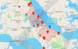
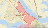
Whatever your sources if you're trying to make a point with map comparisons it helps to have the maps at/near the same scale.One is a screenshot of the DJI geo zones in the app...the other is a screenshot of the maps in the FAA gridmap site..
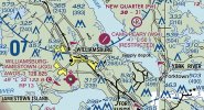
As I mentioined it looks like you're right. If you look at the attached screenshots the one from DJI and two from the FAA appear prove your point about the Camp Peary Airstrip.
On the chart "Restricted" just means you can't land your plane there.
DJI definitely looks to bee adding extra unecessary airspace restrictions.
I am not being faceitous that was a legitimate question.I assume you're being facetious about the use of the word "receptive" If not, ask the unfortunate nano drone owners in India where their ridiculous 15 meter height ceiling was increased by their governing body to 120 meters almost 6 months ago, but dji refuses to remove the limit.
I'm sorry I'm not current on what is happening in India or UAS flying in general.
It's been years since I've flown my P3 or my RC planes and the last time I did it was way out in the middle of nowhere.
I got out of the hobby for a bit because of all the FAA stuff.
Now that were figuring out how the rules are being applied and the LAANC process is in place I decided to get back into it and get my Remote Pilot License and a Air 2.
For all of the mentioned issues it certianly looks better that it did a couple years ago, at least from my perspective. I remember it taking months for people to get permission to fly near airports and other restrictred locations. Now for those locations in the LAANC system it's pretty quick. This is of course assuming the maunfacturer doesn't get in the way as I'm hearing here.
Thanks for all the input!
I came here to get informed and that's what is happening.


