Thanks .. this data shows much more than the previous set.
There is still the problem of no reliable location data after satellite reception was lost.
Here is a short summary of the flight data:
Upload and view flight logs from your DJI drones

www.phantomhelp.com
The loss of GPS is unusual, with the sat numbers decreasing as you climbed higher than 14 metres.
This is similar to a few sets of flight data that I've seen from areas affected by Russian GPS jamming.
Given your location, this might have been what caused the GPS problem.
It could have been that if you had descended below 14 metres, that GPS would have returned?
The reliable GPS data ended at 10:57.5 when the drone was 15 metres above the launch point.
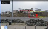
The green curved track is based on location data that could be either approximate or very wrong.
It looks like the data recorded a collision just one minute after the start of the data.
The drone ran into something 24 metres higher than the launch point and came down about one metre before the data stopped.
It might be that the drone came to rest there and signal was blocked by an obstacle, or that the battery was knocked out and the drone could have fallen further?
If you can see an obstacle 24 metres or more high, in the direction the drone flew away, that might be a good place to search.
I'm still puzzled at what caused the drone to zoom away like that.
Losing GPS should not cause that and it must be something else.
I have a few questions that might help me to work out a bit more about the incident.
What direction did you see the drone fly away?
Do you remember which direction the drone was pointing when it was on the home point?
Was it pointing towards the nearest building (southwest) or somewhere else?
What was the surface you launched from?


 I still haven't found it but I assumed it was somewhere on that house on a nearby tree on Seaton Court.