DJI Mavic, Air and Mini Drones
Friendly, Helpful & Knowledgeable Community
Join Us Now

Dji mini 4k hacks

POTATO - POTAHTO, the Mini 4k is not a downgraded Mini 4 Pro...

It is more like an upgraded Mini 2SE with the upgraded firmware to upgrade the camera from 2.7K to 4K... There may be other small differences but they are all a moot point.

My Mini 2 can shoot 4K so numbers do not mean a tihing...
 
Last edited:
I tried to reset the home point as you said (not landing) and it only did reset the horizontal distance to 0. The height did not change. So at least with this drone it's not possible. But thank you for giving ideas :)
Height is always relative to the original take off point. It only resets if you manage to land, stop the motors, restart the motors and take off again.
 
Nah... very difficult situations to control in the mountains if there are no large, flat areas that are clearly visible from below.
This could be a great way to crash or lose the drone's signal during or shortly after landing far away and in that case you would probably lose the drone too if you don't have a good chance of going to retrieve it.

On signal loss it will initiate Failsafe RTH and return to the home point.

There is no greater risk of losing the drone attempting staged mountain climbing due to signal loss than the same from going behind a building, tree, hilltop.

There is increased risk of straightline crash into a tree or other obstacle during RTH because you will be close or above the set RTH altitude. You can mitigate this by choosing unencumbered intermediate landing steps on the way up.
 
  • Like
Reactions: LoudThunder
There is no greater risk of losing the drone attempting staged mountain climbing due to signal loss than the same from going behind a building, tree, hilltop.
If you hiking in the mountains and using the drone to video your trip while you are traveling, periodically reset your Home Point at a clearing that the drone can safely land if signal is lost. You do this so that the drone does not perform a RTH to whereever you originally took off from way down the mountain…

Additionally, if you are hiking up the mountain and you hike up-hill 300' up the mountain and you set the original RTH altitude to 300', then the new Home point is located at your maximum altitude and the drone does a RTH, the drone would fly right into the ground when it is headed to the new home point.

The reverse is true of the RTH altitude when descending. If you had descended 300' down the mountain and you reset the home point and the drone does a RTH, it would climb to 300' above your original launch point and then fly to your new home point which is now 300' below the original point and your drone would now be at 600' above your new home point…
 
Additionally, if you are hiking up the mountain and you hike up-hill 300' up the mountain and you set the original RTH altitude to 300', then the new Home point is located at your maximum altitude and the drone does a RTH, the drone would fly right into the ground when it is headed to the new home point.

Could you elaborate on this? I couldn't follow.

Our drones have no altimeter. Mountain climbing necessarily involves periodically landing and then taking off again as the means to reset the height limit, which also resets the 2D coordinates on the surface of the HP.

When you take off again, it's like the first take off – there is no "memory" of the previous segments, their height relative to the current takeoff point, etc.

Taking your example, if you fly up to 300', with RTH set to 300', then land and take off again, the RTH height will be 300' over your new takeoff point, 600' above your starting point where you're standing with the RC.

Remember, there is no max altitude, only a max height above takeoff altitude, which is reset to zero at each takeoff, and then all height settings (height limit, RTH, etc.) are relative to that location.
 
Last edited:
Could you elaborate on this? I couldn't follow.
With the longer flight times of the new batteries, you might keep flying without landing while you are hiking. But while the drone is flying, you can "Update the Home Point" (it is in the Safety Menu) while the drone is in the air (hence the remark about making sure the drone is over an area that is clear of trees…)

If you perform the Update the Home Point while the drone is in flight, it has no basis for a new altitude since it did not land and reset its flight parameters.

This is often done with a drone that is being used over water from a boat. Also, most folk who fly over water do this, they also set the drone to Hover, rather than land in case it takes a bit of time to get under the drone so it does not land in the water… This Updating of the Home Point also prevents the drone from trying to fly back to shore if it goes into RTH, especially if you are recording a trip and you have traveled a distance from the launch point.

Here is a test… If by chance you have an elevated area (like a second story porch or deck…) that you might be able to launch your drone from, try this… Take off from the elevated area and then if you land in your driveway, the altitude will show a negative reading by the difference in the height of the elevated area…. Do it again, but this time while the drone is flying, Update the Home Point and then again land in the driveway, the same negative reading will show.

I hope this makes sense.
 
Okay, I think I understand.

You're talking about something very different than the subject of this thread: Working around the height limit when ascending up the side of a mountain while maintaining legal AGL and the pilot stays in the same originial takeoff location.

The method necessarily requires periodic landing on the way up the slope to reset the height reference. The pilot doesn’t move. There's no risk of RTH hitting anything.

If I understand your scenario, it's about hiking up a mountain with a drone, the pilot is moving, and is resetting the HP in flight to be closer to them should Failsafe RTH be triggered, correct?

Regardless, if it's a hike up a mountain significantly taller than 120m, in the EU you'll be landing to reset the reference anyway every 120m, so the point's kinda moot.
 
so the point's kinda moot.
When on flies a drone in the mountains, I I do not think one has much to worry about if they exceed the maximum altitude, who is going to know, how are they going to know, so as you wrote, it's really a moot point…

It's just that over the years, I have seen and read about so many different problems folks have experienced when the drone performs a RTH. One of the things that I recommend is that folks should practice the RTH and not be dependent on always flying FPV. In a large clearing away from trees, obstacles, and people. Fly your drone out 50-meters or so (DJI drones will not RTH if closer than 20-meters to the home point) and turn off the controller. It a scary thing… Your drone starts climbing up and up and then when it is almost out of sight, it starts coming back (you hope…). Also do it when your phone or tablet is so equipped… Turn that off and activate the RTH on he controller.

Also, with you flying your drone in the mountains with lots of trees, you need to understand how to activate the Find My Drone and just how it works… And understand just how loud the buzzing is and just how bright the flashing is… Both of which really are useless to finding a drone lost in the trees and they stop working when your battery finally dies…

I use a Ruko RID Module and it has a range of about 500' and my cell phone can easily pick it up and the Ruko has a 5-hour battery life… Plenty of time to find a drone.

Just for fun, a few more horror stories for laughs to learn from other's mistakes… Two folks I know like to fly their drones around the neighborhood while sitting in the shade of their garages… Both flew FPV and both had occasions when their drone went into RTH. Both drones did when they were expected to do, they RTH but since they were inside the garage when they took off, they went back to those coordinates, but guess what, the roofs of the garages were between them and the launch point and both drones landed on the roofs. One landed on the second story and the roof was too inclined and the drone would not activate its motors to take off again and the guy had to hire a guy to come over to retrieve his drone… The other guy, did not have that problem, his drone slide off the roof and crashed onto the driveway, luckily he had Care Refresh, but it still cost him…

The third incident, the guy was flying around a river and he took off from the river bank, from under trees, and flew out to get over the water… Later, his drone also did a RTH, but like the garage sitters… this drone flew over the launch point, but there were trees and the drone landed in the trees and it was never recovered…

Fly Safe and have tons of fun!
 
When on flies a drone in the mountains, I I do not think one has much to worry about if they exceed the maximum altitude, who is going to know, how are they going to know, so as you wrote, it's really a moot point…

You're missing a key point here: Folks in the EU have a hard ceiling of 120m/400ft limited in Fly on the max height slider. So, to fly up the side of a mountain from a fixed location, higher than 400ft, requires flying up to near 400ft, land to reset height, takeoff again, repeat.

RTH shouldn't be at risk of hitting limits and crashing into terrain any more under this scenario than any other, seems to me.
 
  • Wow
Reactions: LoudThunder
You're missing a key point here
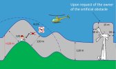
I believe you are missing the point, the European Union's "Hard Limit" of maximum height is 120-meter "above ground level," not 120-meters above the launch point. Please refer to the graphic below taken from the European Union Aviation Safety Agency Web Site…

Drones | EASA

What I am saying is if the European drone pilot is in good health and capable or hiking up a hill or mountain from the trailhead to the lookout point (600-feet above the trail head) in about a-half hour (one batteries' flying time…) and they put the drone in "follow-me mode at about 30-feet above their head;" they will arrive at the lookup and the altitude in the telemetry of the controller will read 630-feet, but since the drone never got higher than 30-feet above the pilot's head, it never exceeded the max altitude of 120-meter Above Ground Level limit of the European Union…

height.jpg
 

DJI Drone Deals

New Threads

Members online

Forum statistics

Threads
134,860
Messages
1,599,173
Members
163,318
Latest member
Craig3337
Want to Remove this Ad? Simply login or create a free account